
Rum, Salisbury's Dam


Bridge (19th Century), Dam (19th Century), Lade (19th Century)
Site Name Rum, Salisbury's Dam
Classification Bridge (19th Century), Dam (19th Century), Lade (19th Century)
Alternative Name(s) Rhum
Canmore ID 21880
Site Number NM39NE 27
NGR NM 36421 99896
NGR Description NM 3642 9989 to NG 3669 0004
Datum OSGB36 - NGR
Permalink http://canmore.org.uk/site/21880


- Council Highland
- Parish Small Isles
- Former Region Highland
- Former District Lochaber
- Former County Inverness-shire
Field Visit (June 1983)
Salisbury's Dam NM 364 999 NM39NE
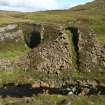
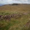
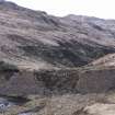
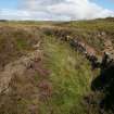
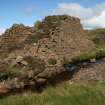
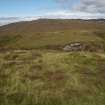
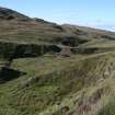
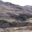
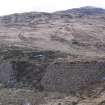
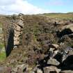
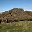
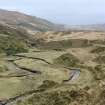
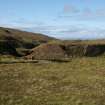
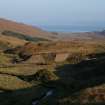
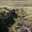
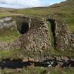
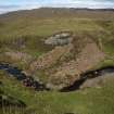
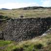
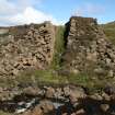
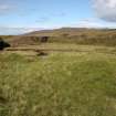
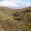
This massive structure was built in the late 1840s to divert the headwaters of the Kilmory River through a rock-cut lade into the Kinloch River, but was breached at the NW end a few days after the reservoir was filled. The curving dam is formed by two battered drystone walls enclosing an earth core and measures 10.5m in thickness at the base by about 5.8m in height. Its original length was about 60m of which 45m survive. The lade (NM 364 999 to NG 367 000) measures about 300m in length and includes a rock-cut section up to 7m wide and 4m deep. The footings of a rectangular building (9.2m by 3m internally) are situated on the S side of the lade 190m ENE of the dam.
RCAHMS 1983, visited June 1983
Reference (1995)
Two contemporary stone buttresses are bonded into the front of the dam. Upstream [sic] from the building are the remains of a bridge which once formed access across the channel.
NMRS MS/868/1
Field Visit (August 2011)
This large dam, which remains as described in 1983, was designed to divert water via a ditch from the Kilmory River, which flows north from the dammed Loch Long (see NM39NE 38), into a tributary of the Kinloch River some 480m away (at NG 3680 0027) via an artificial cut at its eastern end.
The purpose of this dam was to provide a means of access for salmon from the Kinloch River to the loch, improving both the river and the loch for fishing. Its construction was part of a second phase of works undertaken c1854, the first involving the damming of the Long Loch and the insertion of a cut to take its waters to Kilmory, and the third involving the construction of a dam and aqueduct to carry that outflow into Kinloch River.
Half-way along the cut is a second, smaller dam (NG30SE 56) which is described elsewhere.
Visited by RCAHMS (GFG) August 2011.

