
Rum, Malcolm's Bridge 4


Shieling Hut(S) (Post Medieval)
Site Name Rum, Malcolm's Bridge 4
Classification Shieling Hut(S) (Post Medieval)
Alternative Name(s) Rhum
Canmore ID 21876
Site Number NM39NE 23
NGR NM 35465 98403
NGR Description Centred at NM 35465 98403
Datum OSGB36 - NGR
Permalink http://canmore.org.uk/site/21876


- Council Highland
- Parish Small Isles
- Former Region Highland
- Former District Lochaber
- Former County Inverness-shire
Field Visit (June 1983)
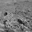
Malcolm's Bridge 4 NM 354 983 NM39NE
A group of four oval or subrectangular huts is situated 180m E of the road to Harris. The best-preserved measure 3.4m by 1. 7m and 1.8m by 1. 7m respectively within drystone walls standing up to 0.7m in height; of the remaining huts one, to which a small enclosure is attached, has been reduced to little more than its stone wall-footings, and the other now appears as a grass-covered stony mound 6m across and 0.7m high.
RCAHMS 1983, visited June 1983

