
Mull, Dun Mhadaidh


Dun (Period Unassigned)
Site Name Mull, Dun Mhadaidh
Classification Dun (Period Unassigned)
Canmore ID 21852
Site Number NM35SE 6
NGR NM 3914 5260
Datum OSGB36 - NGR
Permalink http://canmore.org.uk/site/21852


- Council Argyll And Bute
- Parish Kilninian And Kilmore
- Former Region Strathclyde
- Former District Argyll And Bute
- Former County Argyll
NM35SE 6 3914 5260.
(NM 3914 5260) Dun Mhadaidh (NR)
OS 1:10,000 map, (1976)
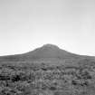
Dun, Dun Mhadaidh: This dun is situated on the elongated rocky boss that crowns the summit of the conspicuous hill about 800m SSE of Langamull farmhouse. An irregular oval on plan, it measures 12m by about 10.5m within a well built dry-stone wall, varying in thickness from about 3m near the entrance to 5.2m on the N, where the lowest course of the outer face is set some 3.3m below the level of the summit. Several stretches of both the inner and outer faces survive in situ, although in most cases only a single course can now be seen. Within the thickness of the wall on the N there is a short length of outward-facing revetment, and it may be presumed that this feature was carried round the entire NE quadrant. On the SW, where the line of the inner face is interrupted for a short distance, two earthfast stones in the body of the wall appear to form part of the side-walls of a narrow passage, probably giving access to some intramural feature.
The entrance, in the SE, is unusually narrow and does not seem to have been checked for a door. It is uncertain whether the eartfast slab that lies across its outer end indicates that the entrance was blocked in some secondary phase of occupation, or merely that the lowest course of the outer face had always continued across the mouth of the entrance. The interior of the dun is grass-covered and remarkably level, which suggests that it may have been used as an enclosure in relatively recent times.
On the NW and SE respectively, where the level area of the summit extends a little distance beyond the dun, there are traces of two outer walls. That on the NW appears as a continuous band of stony debris, in which only a single short stretch and two isolated stones of the outer face are visible. The other has been reduced to two fragments, on the crest of a lwo rock-face. On the flanks of the hill and on the edge of the terrace below the dun on the N there are a number of turf-and- stone dykes of no great age.
Surveyed at 1:10,000.
RCAHMS 1980, visited 1973; Visited by OS (RD) 13 June 1972.
Field Visit (8 June 1934)
Dun, Moadaidh Mornish. An isolated rock of a ridge among fields once cultivated, bank and ?fosse at foot of rock on N and E. Walls 12-13' thick internally and 38' in diameter.
Visited by VG Childe 8 June 1934.
Notes and typescripts filed with RCAHMS Emergency Survey material.
Field Visit (2 July 1943)
This site was included within the RCAHMS Emergency Survey (1942-3), an unpublished rescue project. Site descriptions, organised by county, vary from short notes to lengthy and full descriptions and are available to view online with contemporary sketches and photographs. The original typescripts, manuscripts, notebooks and photographs can also be consulted in the RCAHMS Search Room.
Information from RCAHMS (GFG) 10 December 2014.

