
Mull, Poit Na H-i


Standing Stone (Prehistoric)
Site Name Mull, Poit Na H-i
Classification Standing Stone (Prehistoric)
Alternative Name(s) Pottie
Canmore ID 21773
Site Number NM32SW 2
NGR NM 3250 2217
Datum OSGB36 - NGR
Permalink http://canmore.org.uk/site/21773


- Council Argyll And Bute
- Parish Kilfinichen And Kilvickeon
- Former Region Strathclyde
- Former District Argyll And Bute
- Former County Argyll
NM32SW 2 3250 2217.
(NM 3250 2217) Standing Stone (NR)
OS 1:10,000 map, (1976)
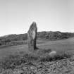
Standing Stone, Poit na h-I: This granite standing stone is situated in a gently sloping arable field 365m N of Poit na h-I farmhouse and 90m W of the approach road to the farm. Irregular in shape, it is roughly triangular at the base, measuring 0.8m by 0.7m by 0.4m, and rises to a height of 2.4m. Some stones cleared from the field have been piled round its base.
RCAHMS 1980, visited 1973.
This standing stone is as described.
Surveyed at 1:10,000.
Visited by OS (DWR) 5 June 1972.
Scheduled as Poit na h-I (Pottie), standing stone.
Information from Historic Scotland, scheduling document dated 26 February 2003.
Field Visit (28 June 1943)
This site was included within the RCAHMS Emergency Survey (1942-3), an unpublished rescue project. Site descriptions, organised by county, vary from short notes to lengthy and full descriptions and are available to view online with contemporary sketches and photographs. The original typescripts, manuscripts, notebooks and photographs can also be consulted in the RCAHMS Search Room.
Information from RCAHMS (GFG) 10 December 2014.

