
Iona, Sraid Nam Marbh


Road (Period Unassigned)
Site Name Iona, Sraid Nam Marbh
Classification Road (Period Unassigned)
Alternative Name(s) The Street Of The Dead
Canmore ID 21623
Site Number NM22SE 16
NGR NM 2845 2385
NGR Description From NM 2845 2385 to NM 2858 2453
Datum OSGB36 - NGR
Permalink http://canmore.org.uk/site/21623


- Council Argyll And Bute
- Parish Kilfinichen And Kilvickeon
- Former Region Strathclyde
- Former District Argyll And Bute
- Former County Argyll
NM22SE 16 2845 2385 to 2858 2453.
(NM 2845 2385 - NM 2858 2453) Street of the Dead (NR) (Site of)
OS 6" map, Argyllshire, 2nd ed., (1900)
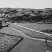
"Sraid nam Marbh" - "Street of the Dead" - a processional way dating from about 1000 and running from the original landing place at the head of Martyr's Bay to the Reilig Orain (NM22SE 10).
The cobbled street which has been exposed running from the graveyard to the Abbey (NM22SE 5) is a later extension which gives some idea of its regular but extremely rough character - about 7' wide and composed of boulders of red Mull granite with a carefully constructed kerb of flat schist slabs.
A C Thomas 1959; R Reece nd; A C Thomas 1959.
There is no trace of this street from Martyr's Bay to the Reilig Orain. However, N of the graveyard at NM 2859 2445 the boulder-laid street is exposed and terminates at the ruins of the "Old Guest House" at NM 2863 2452.
Surveyed at 1:2500.
Visited by OS (JP) 8 June 1972.
Field Visit (8 June 1972)
There is no trace of this street from Martyr's Bay to the Reilig Orain. However, N of the graveyard at NM 2859 2445 the boulder-laid street is exposed and terminates at the ruins of the "Old Guest House" at NM 2863 2452.
Surveyed at 1:2500.
Visited by OS (JP) 8 June 1972.
Excavation (22 January 2013)
NM 2860 2450 Road of the Dead A small trench was excavated over the line of the cobbled roadway at its S end. The trench (2.0 x 0.8m) recorded a surface consisting of large, water-rounded red granite boulders. The full width of the road was not confirmed, but it was partially sealed (on the W) by a deposit of ploughsoil.
Sponsor: Historic Scotland
D Murray 2013
Kirkdale Archaeology

