
Knowe Of Rowiegar


Chambered Cairn (Neolithic), Inhumation(S) (Neolithic), Souterrain (Iron Age), Unidentified Pottery (Neolithic)
Site Name Knowe Of Rowiegar
Classification Chambered Cairn (Neolithic), Inhumation(S) (Neolithic), Souterrain (Iron Age), Unidentified Pottery (Neolithic)
Canmore ID 2159
Site Number HY32NE 1
NGR HY 3734 2977
Datum OSGB36 - NGR
Permalink http://canmore.org.uk/site/2159


- Council Orkney Islands
- Parish Rousay And Egilsay
- Former Region Orkney Islands Area
- Former District Orkney
- Former County Orkney
HY32NE 1 3733 2978.
(HY 3733 2978) Mound (NAT)
OS 6" map, Orkney, 2nd ed.,(1900).
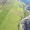
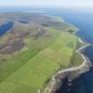
Knowe of Rowiegar, an Orkney-Cromarty type stalled cairn, now a grass-covered mound with a few slabs projecting near the centre.
The mound was excavated by W G Grant in 1937, who found that the SE end had been so badly damaged that it obscured all trace of the entrance, and that an earth-house had been constructed in the easternmost half of the cairn. Other Iron Age building, datable by pottery (J Phemister 1942) and other relics, lay on and around the cairn.
The mass of masonry (the unhatched area in Fig.26, A S Henshall 1963) which lies at the SE end of the cairn is too dilapidated for identification but from it springs a thick wall which curves towards the shore. A similar wall springs from the NW corner of the cairn, at which point the absence of a bond can be clearly seen. Similar walls occur at Mid Howe (HY33SE 1).
On the NE side of the cairn, near the NW end, some further remains have been uncovered. These consist partly of masonry foundations and partly of slabs set on edge. There is also a socket-stone, apparently intended to receive the pivot stone of a door. Possibly to be connected with this occupation are the buildings which seem to have risen on the summit of the cairn at some time after its upper parts had fallen into ruin. Numerous finds from the site, including pottery and stone implements, are in the National Museum of Antiquities of Scotland (NMAS).
RCAHMS 1946; J Phemister 1942; A S Henshall 1963.
The Knowe of Rowiegar, a stalled cairn, is as described and illustrated by the above authorities.
Resurveyed at 1/2500.
Visited by OS (NKB) 11 June 1967.
Rectangular Orkney-Cromarty cairn with stalled chamber. Radiocarbon dates from unstated contexts:
Cattle bone 2355 +/- 60 bc (Q-1221)
Deer bone 2055 +/- 60 bc (Q-1227)
J L Davidson and A S Henshall 1989.
Field Visit (1941)
Visited by Childe in 1941.
V G Childe 1942
Orkney Smr Note (September 1980)
Artefacts : NMA EO 670-724
Human rems : Dept of Anatomy, University of Aberdeen
Animal rems: Royal Scottish Museum
===============================================================
An Orkney-Cromarty stalled cairn in the E half of which an
Iron Age structure of earthhouse type had been built.
RCAMS visited in July 1936 at which time it was a large
grassy mound with stones projecting from the top; then excavated
by W G Grant and account revised March 1938. There is no
separate excavation report published, but a specialist report on
the mineralogical analysis of the pottery appeared in 1942.
[R1], [R2]
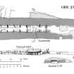
The cairn is rectangular, 90ft NW-SE x 18ft 6in to 21ft 6in;
external facing wall survives to 2ft 3in high. Ten compartments
out of a probable original twelve survive, some with low shelves
along the walls. Two thick walls spring from the W and SE
corners and run down to the shore. [R3], OS visit Jun 67.
C14 dates of 2055 +- 6 BC and 2355 +- 60 BC (calibrated to
2600 +- 110 BC and 3035 +- 110 Bc) from ox and red deer bones.
[R4]
As described, but dilapidated.
Information from Orkney SMR (RGL) Sept 80.
Field Visit (September 1980)
Knowe of Rowiegar (ORK 31) HY 3733 2978 HY32NE 1
Dilapidated stalled cairn, in part of which an Iron Age structure had been built; walls spring from opposite ends and run down to shore. Excavation by Grant in 1938; unpublished. Finds in NMAS.
RCAHMS 1982, visited September 1980
(Wilson Portfolio f. 12; Phemister and Scott 1942, 132; RCAHMS 1946, ii, pp. 218-20, No. 578; Henshall 1963, 214-15; Switsur and Harkness in Renfrew 1979, 72 and 206; OR 553)
Magnetometry (16 April 2018 - 26 April 2018)
HY 37051 30722 (North Howe), HY 37274 30377 (South Howe), HY 37352 29774 (Knowe of Rowiegar), HY 37531 29661 (Knowe of Swandro), HY 37626 29296 (Westness Viking Houses), HY 4398 3224 (Rinyo) and HY 40065 27452 (Burrian)
The RGK undertook a survey campaign on Rousay, 16 – 26 April 2018, as part of the Boyne to Brodgar Project. It aimed to provide a landscape perspective of two Neolithic core areas on the island – Westside and Rinyo. Moreover, the diachronic development in both areas will be researched, concentrating on the processes of formation and degradation of land use over time.
At Westside the survey area stretched from Westness Farm in the S to the rugged area N of North Howe, where the rocky surface and shrubbery prevented further activity (c56ha). The survey focused on the lower fields close to the coast and to the known Neolithic chambered cairns of Knowe of Swandro, Knowe of Rowiegar and Mid Howe. Some fields had to be omitted because the device could not drive across their steep slopes and rocky ground. Several new anthropogenic anomalies and structures can be observed in the imagery. In the SE field of the surveyed area a possible new mound is most striking. A circular structure, 9.5m in diameter, of high magnetic susceptibility was evident about 250m NW of the mound. In the N further settlement structures surrounding North Howe Broch have been revealed. Track-like linear structures follow downhill from the N towards the SW, and E of these, and NW of North Howe several possible settlement structures are evident. Three circular roundhouse structures are located 20m N of the broch, their diameter is between 8.5 and 11m. Immediately W of North Howe a concentration of stone might result from broch related debris, but could also reveal remains of further building activity in this location. Further investigations will hopefully reveal details about the chronology and function of some of the anomaly clusters.
The Neolithic settlement of Rinyo is positioned in a valley between Faraclet Head and Kierfea Hill in the N of Rousay. During the survey, 50.5ha of gradiometer data were captured from fields surrounding Bigland and Houseby Farms in the S of the valley. The NW area of the survey showed traces of ploughing and some field boundaries. Apart from the interior structuring of Rinyo settlement site several new features have been identified in the adjacent fields to the N and S. A circular to oval structure of 20 – 22m in diameter is positioned about 40m NW of Rinyo’s extent. Inside the settlement, internal details can be identified, and the magnetic susceptibility of the structure is relatively high with values up to 18.0 nT. In the field SE of Rinyo, a cluster of several structures is evident. Several circular and semi-circular features with diameters between 12 – 22m, as well as linear anomalies, signify a focus of settlement activity. About 100m SE of the modern Bigland Farm a further nucleus of settlement or burial activity of uncertain date and type was found. A linear structure in the SW of the surveyed area could result from an igneous dyke. Several anthropogenic anomalies can be found around the dyke.
Two fields were surveyed N of Burrian Broch on the S coast of Rousay. Part of the broch has eroded into the sea and the part facing the coast was not accessible with the 3m rig. The N part of the cavity wall and the possible outer boundary ditch are visible in the magnetometry data. The fields contain dipole anomalies, probably resulting from modern metal waste. Some faint traces of rig and furrow-like features can be detected in the areas close to the coast. Several linear features of higher magnetic susceptibility may also be of modern origin (heavily burnt material was visible on the ground surface).
This report highlights some of the larger structures brought to light with the surveys. Many further features, visible of in the imagery, are still undergoing analysis, and more complementary work is needed to further identify their function and chronology, and their meaning in the composite usage of the land.
Gradiometer survey was predominantly conducted with a GPS-supported 14-sensor fluxgate GM650B gradiometer device mounted on a quad-drawn 3m wide rig. At Westside, the fields close to the sea were not accessible with the large rig. These were surveyed with a 2m rig mounted with five sensors with a similar technical configuration to the larger one.
The works were carried out in collaboration with the University of the Highlands and Islands Archaeology Institute, Orkney College, County Archaeologist Julie Gibson, Orkney Islands Council, the National Museum of Scotland and University College Dublin.
All survey results are reported to Historic Environment Scotland and the Rousay Community
Funder: RGK
Ruth Beusing and Knut Rassmann – Römisch-Germanische Kommission, Frankfurt (RGK) of the German Archaeological Institut (Deutsches Archäologisches Institut)
(Source DES Volume 19)
Note (2020)
Knowe of Rowiegar
This burial site in Orkney Islands was a focus for funerary practices in the Neolithic period, between 4000 BC and 2451 BC.
Prehistoric Grave Goods project site ID: 60111
CANMORE ID: 2159
Total no. graves with grave goods: 1
Total no. people with grave goods: 12
Total no. grave goods: 5
Prehistoric Grave Goods project Grave ID: 74043
Grave type: Chamber
Burial type(s): Inhumation, Inhumation, Inhumation, Inhumation, Inhumation, Inhumation, Inhumation, Inhumation, Inhumation, Inhumation, Inhumation, Inhumation
Grave good: Unknown Object
Materials used: Bone/Antler/Horn/Ivory/Tooth (Animal) [Bone]
Current museum location: Unknown
Grave good: Assemblage
Materials used: Bone/Antler/Horn/Ivory/Tooth (Animal) [Bone]
Current museum location: Unknown
Grave good: Assemblage
Materials used: Bone/Antler/Horn/Ivory/Tooth (Animal) [Bone]
Current museum location: Unknown
Grave good: Pot
Materials used: Pottery
Current museum location: Unknown
Grave good: Pot
Materials used: Pottery
Current museum location: Unknown
Further details, the full project database and downloads of project publications can be found here: https://doi.org/10.5284/1052206
An accessible visualisation of the database can be found here: http://blogs.reading.ac.uk/grave-goods/map/

