
Tiree, Dun Mor A' Chaolais


Broch (Iron Age)
Site Name Tiree, Dun Mor A' Chaolais
Classification Broch (Iron Age)
Canmore ID 21485
Site Number NM04NE 1
NGR NM 0832 4767
Datum OSGB36 - NGR
Permalink http://canmore.org.uk/site/21485


- Council Argyll And Bute
- Parish Tiree
- Former Region Strathclyde
- Former District Argyll And Bute
- Former County Argyll
NMO4NE 1 0832 4767
For adjacent cup-markings (NM 083 476), see NM04NE 16.
(NM 0832 4767) Dun Mor a' Chaolais (NAT)
Brock (sic) (NR)
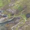
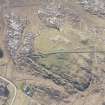
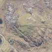
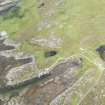
Broch, Dun Mor a' Chaolais: The rounded summit of Dun Mor a' Chaolais, a low rocky hill (39m O D) which dominates the NE end of Tiree, is occupied by the remains of a broch and its outwork. The position commands extensive views in all directions but does not provide a great degree of natural protection.
Measuring approximately 12m in internal diameter, the broch has been defended by a dry-stone wall originally about 3.7m thick but later increased to as much as 5.8m; it has been denuded by stone-robbing, presumably to provide material for the modern dykes that cross the site. The NE portion has been particularly severely disturbed. On the SW, however, the wall survives as a grass-covered stony bank about 1.5m high, in which several stretches of inner and outer facing-stones have been preserved in position. Within the body of the wall on the ESE there appears to be a small mural chamber, and a pronounced depression in the bank on the SSE may indicate the position of another. On the SW there are traces of a well-built intramural gallery which measures about 0.8m wide and was formerly much more extensive; it is probable that another intramural feature, perhaps a guard-cell, is concealed by the ruined foundations of a relatively recent rectangular building overlying the wall on the W, immediately to the S of the entrance.
An external revetment 2.1m in greatest thickness has been built against the outer face of the broch on all sides, presumably to give added stability to the dry-stone wall, but possibly also to allow it to be increased in height. It is best preserved on the SW half of the perimeter, where it appears as a stony scarp about 1m high, at the foot of which several stretches of outer facing-stones may be seen; many of these are of considerable size and less regular in shape than those of the original outer face, the difference in the character of the walling being so marked as to put the secondary nature of the revetment beyond doubt.
An Ordnance Survey triangulation station has been constructed on top of the broch wall on the N, and a modern marker-cairn overlies the line of the inner face on the W.
The outwork appears to have sprung from the outer face of the main work on the W, but the points of contact have been obscured by relatively modern disturbance, presumably associated with the construction of the sub-rectangular enclosure that straddles the line of the wall in this quarter. On the SW half, where it is best preserved, it survives at present as a grass-grown stony scarp, up to 1.6m in height, in which several long stretches of outer facing-stones are still visible; at one point the outer face stands 1m high in two courses. There is an entrance 2.1m wide on the S, and it is probable that another, situated somewhere within the wide gap on the N, has been destroyed to provide easier access to the now ruined rubble-built enclosure, of no great age, that lies to the N of the broch.
(Beveridge (E Beveridge 1903) picked up decorated pottery at this site, and notes that earthenware whorls are said to have been found.)
RCAHMS 1980; E W MacKie 1963; E Beveridge 1903.
Resurveyed at 1:2500.
Visited by OS (D W R) 24 June 1972.
Publication Account (2007)
NM04 3 DUN MOR a’ CHAOLAIS
NM/0832 4767
This probable ground-galleried broch on Tiree stands on the summit of a low rocky hill on the east coast of the island, in a position with extensive views (visited 8/62). Although the structure is overgrown with turf and dilapidated – there are modern stone dykes near by one of which runs right across the broch, and the north-east arc has been badly disturbed by cultivation – a number of structural details can be seen.
Description
The internal diameter is about 12m and the original wall thickness was about 3.7m. Clear traces of an intramural gallery are visible on the south side, but much more could be seen at the beginning of the 20th century [2]. There is probably a mural cell on the south-east and there are traces of an entrance passage on the north-west. Next to the latter there are signs of a guard cell but this has been covered in modern times by a simple rectangular building, perhaps a watch tower (there was an RAF airfield on Tiree during the 1939-45 war).
The main wall seems to have been thickened with an outer ‘revetment’ at some stage, from 3.7m to up to 5.8m thick and of uncertain original height; it stops at the entrance passage, forming an outward extension to it. The original outer face of the broch, outside the clear traces of the intramural gallery on the south-south-west, can be detected from the north-west anticlockwise round to the south-east, apparently with a break at the entrance. In front of this its inner edge can be seen to project slightly forward from the right side of the original passage, as if to form a new door-check, but anything similar on the opposite side is obscured.
There are traces of an outer wall running right round the site, though it may in fact join the broch wall on the west side. Several lengths of its outer facing stones can be seen, and there is an outer gateway on the south 2.1m wide.
Discussion
Though unexcavated the site is an interesting one because of the clear added masonry resting against the outer wallface. The purpose of this addition is unclear and will remain so unless an excavation is undertaken. It may have been designed to give extra stability to the broch wall [4] or – and more probably in the author’s view – it may be the remains of demolition debris, that is, stones taken from the upper parts of the tower and carefully stacked against the base of the wall. The revetment at Dun Arkaig on Skye (NG34 2) is probably to be explained in this way also.
This interpretation is made more plausible by what appears to be an added door-frame immediately in front of the old entrance. If this is what it is it suggests that the old entrance passage was wrecked at some stage, and the primary door made unusable, so that a new one had to be arranged. A similar phenomenon can be seen at Dun Telve (NG81 2), at Gurness in Orkney (HY32 2) as well as at a number of other sites. Dun Mor a’ Chaolais should well repay systematic excavation.
Sources: 1. NMRS site no. NM 04 NE 1: 2. Beveridge 1903, 75: 3. Discovery and Excavation in Scotland 1963, 21: 4. RCAHMS 1980, 91-2, no. 166 and fig. 90.
E W MacKie 2007

