
Berneray, Barra Head Lighthouse


Fort (Prehistoric), Galleried Dun (Prehistoric)
Site Name Berneray, Barra Head Lighthouse
Classification Fort (Prehistoric), Galleried Dun (Prehistoric)
Alternative Name(s) Sron An Duin
Canmore ID 21379
Site Number NL58SW 4
NGR NL 5485 8023
Datum OSGB36 - NGR
Permalink http://canmore.org.uk/site/21379


- Council Western Isles
- Parish Barra
- Former Region Western Isles Islands Area
- Former District Western Isles
- Former County Inverness-shire
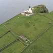
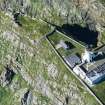
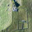
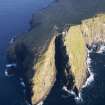
Dun Sron an Duin, Iron Age Massive drystone wall within the grounds of the lighthouse, bounded on two sides by cliffs over 600 ft high. Formerly thought to have been built as a curved wall across the neck of the promontory, the broch-like construction suggests that it was probably originally a full enclosure. It contained two superimposed galleries, the lower one still with some of its lintel stones. The north section (with smaller stones) was probably rebuilt by the lighthouse keepers; a doorway incorporates elements of the original entrance. "There is an old Fort in this Island, having a Vacuity round the Walls, divided in little Apartments", observed Martin in 1695.
Taken from "Western Seaboard: An Illustrated Architectural Guide", by Mary Miers, 2008. Published by the Rutland Press http://www.rias.org.uk

NL58SW 4 5485 8023.
(NL 5485 8023) Dun (NR)
OS 6"map, Inverness-shire, 2nd ed., (1904)
Sron an Duin, the promontory upon which stands Barra lighthouse, is occupied by a galleried dun, according to Feachem (R W Feachem 1963).
A massive drystone wall, some of the blocks of which are up to 7 ft in length and over 2 1/2 ft in width, curves convexly towards the land, cutting off an area about 45 yds by 14 yds which has been hollowed out at some time, leaving a ragged parapet of rock 6 to 10 ft in height all round.
Thomas (F W L Thomas 1890) states that the wall was 95 ft in length, 15 ft in thickness and 13 ft high, but the RCAHMS, in 1915 (RCAHMS 1928), found it to be only 9 ft in height on the outer side for the greater part of its length. They could not measure its thickness as the inner side was broken down and debris-covered, except at the N wall of the entrance-passage where it measured 13 1/2 ft. Abutting upon the outer face of the wall are the two precinct walls of the light-house.
Twelve ft from the NW cliff edge along the outer face of the wall is the paved entrance passage, still 5 1/4 ft in height and, at the time of its erection, 4 ft in width. But later walling against the SE passage face has reduced the width to 26 inches for a distance of 5 1/2 ft. There is a door check on the NW wall 3 1/2 ft from the outside, with a bar-hole behind it. Three lintel-slabs remain above the passage covering it for a distance of 3 3/4 ft.
The remains of two galleries, one above the other, are visible in the wall S of the entrance. Thomas (F W L Thomas 1890) says that the ground gallery began at the entrance passage at 8 ft from the outer wall and at that point was 3 1/2 ft wide, while Anderson's (J Anderson 1893) plan shows the S end complete. The RCAHMS found the lower gallery, where extant, to be 3 3/4 ft wide and to have lintel-slabs remaining in three places. The upper gallery retains its outer wall 52 ft in length on the inside, 5 1/2 ft in thickness and 3 1/2 ft in height above the lintel-slabs of the lower gallery.
R W Feachem 1963; RCAHMS 1928; F W L Thomas 1890; J Anderson 1893.
As described above.
Visited by OS (N K B) 21 May 1965.
BY17: A galleried dun, incorporated into the perimeter wall of the Barra Head lighthouse. Much destroyed by 19th-century building activity, the dun wall survives only on the E and SE sides. Long thin slabs of the gallery can still be seen built into the inside face.
P Foster 1992a; NMRS MS/595/7.
Field Visit (10 June 1915)
Dun, Barra Head Lighthouse, Berneray.
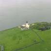
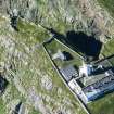
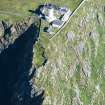
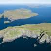
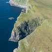
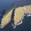
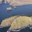
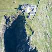
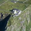
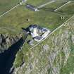
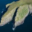
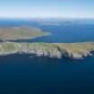
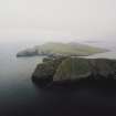
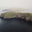
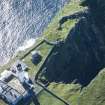
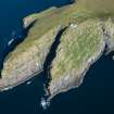
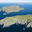
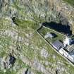
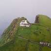
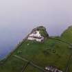
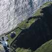
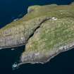
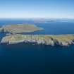
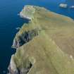
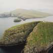
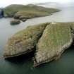
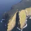
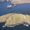
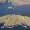
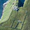
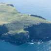
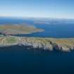
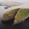
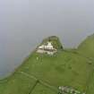
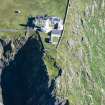
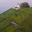
Barra Head Lighthouse is built on the highest point in the island of Berneray, not on Barra Head proper, which is the most southerly point in the Outer Hebrides, but near the end of a small promontory, Sron an Duin, about ¾ mile to the north-west and ¼ mile east of Skate Point, the most westerly point in the island. This promontory within the grounds of the lighthouse is the site of a very interesting fort, which occupies one of the wildest and grandest positions in Scotland, the cliffs by which it is bounded on two sides rising over 600 feet from the Atlantic. A massive drystone wall, curved slightly in the centre towards the land, is built across the promontory and encloses a narrow triangular space about 45 yards long, and about 14 yards across at the centre. The interior has been hollowed out, at what period is not known, leaving a ragged parapet of rock from 6 to 10 feet high all round. On the exterior for the greater part of its length the wall stands 9 feet high, many of the blocks of which it is built being of great size, the largest measuring 7 feet long by 2 feet 9 inches high. Some 12 feet from its western end is the entrance passage which still retains its lintelled roof (Fig. 190). The entrance is 5 feet 3 inches in height and 2 feet 2 inches in breadth and the passage is paved. On the east side of the passage a facing of later construction narrows the entrance for some 5 ½ feet from the outside, when there is a return, 1 foot 10 inches deep, beyond which the original wall is continued inwards for1 foot 3 inches. On the west side the wall of the passage runs in for 3 feet 6 inches, where there is a check of about 6 inches in depth, after which it is carried inwards for 10 feet with a slight curve towards the east. The outer part of this wall on the west of the passage is also curved concavely, so that while it is about 12 feet thick between the passage and the edge of the cliff, at its southern termination, which is 7 feet 3 inches high, it is only 2 feet 7 inches thick. There is a bar-hole, 10 inches high, 9 inches broad, and 3 feet deep, 8 inches behind the check on this side. There is a cavity opposite it on the other side of the passage, but it is not carefully built. The two outer lintels of the passage cover a length of 3 feet 7 inches, and the inner lintel is placed 1 foot higher than the other two. The thickness of the main wall is not ascertainable, as the inner side is broken down and covered with debris, but it has contained two galleries, one superimposed on the other. A number of the lintels of the lower gallery, which is about 3 feet 9 inches wide, remain in position at three places, and the inner face of the outer portion of the wall stands 3 feet 6 inches above them. This outer half of the wall is 5 feet 4 inches thick. On the inside the wall measures 52 feet in length from the entrance to the edge of the cliff. See Proc. Soc. Ant. Scot., Vol. XXVII., pp. 341-6. Martin remarks of Berneray: ‘There is an old fort in this island, having a vacuity round the walls, divided in little apartments’.
RCAHMS 1928, visited 10 June 1915.
OS map: Barra lxx.
Desk Based Assessment (13 October 1964)
(NL 5485 8023) Dun (NR)
OS 6"map, Inverness-shire, 2nd ed., (1904)
Sron an Duin, the promontory upon which stands Barra lighthouse, is occupied by a galleried dun, according to Feachem (R W Feachem 1963).
A massive drystone wall, some of the blocks of which are up to 7 ft in length and over 2 1/2 ft in width, curves convexly towards the land, cutting off an area about 45 yds by 14 yds which has been hollowed out at some time, leaving a ragged parapet of rock 6 to 10 ft in height all round.
Thomas (F W L Thomas 1890) states that the wall was 95 ft in length, 15 ft in thickness and 13 ft high, but the RCAHMS, in 1915 (RCAHMS 1928), found it to be only 9 ft in height on the outer side for the greater part of its length. They could not measure its thickness as the inner side was broken down and debris-covered, except at the N wall of the entrance-passage where it measured 13 1/2 ft. Abutting upon the outer face of the wall are the two precinct walls of the light-house.
Twelve ft from the NW cliff edge along the outer face of the wall is the paved entrance passage, still 5 1/4 ft in height and, at the time of its erection, 4 ft in width. But later walling against the SE passage face has reduced the width to 26 inches for a distance of 5 1/2 ft. There is a door check on the NW wall 3 1/2 ft from the outside, with a bar-hole behind it. Three lintel-slabs remain above the passage covering it for a distance of 3 3/4 ft.
The remains of two galleries, one above the other, are visible in the wall S of the entrance. Thomas (F W L Thomas 1890) says that the ground gallery began at the entrance passage at 8 ft from the outer wall and at that point was 3 1/2 ft wide, while Anderson's (J Anderson 1893) plan shows the S end complete. The RCAHMS found the lower gallery, where extant, to be 3 3/4 ft wide and to have lintel-slabs remaining in three places. The upper gallery retains its outer wall 52 ft in length on the inside, 5 1/2 ft in thickness and 3 1/2 ft in height above the lintel-slabs of the lower gallery.
Information from OS (SW) 13 October 1964
(R W Feachem 1963; RCAHMS 1928; F W L Thomas 1890; J Anderson 1893)
Field Visit (1992)
BY17: A galleried dun, incorporated into the perimeter wall of the Barra Head lighthouse. Much destroyed by 19th-century building activity, the dun wall survives only on the E and SE sides. Long thin slabs of the gallery can still be seen built into the inside face.
P Foster 1992a; NMRS MS/595/7.
Publication Account (2007)
NL58 1 SRON AN DUIN ('Dun Sron Duin', 'Barra Head')
NL/549802
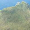
This promontory semibroch stands on the edge of the high cliff on the south side of Barra Head on Berneray, the southernmost island of the Outer Hebridean archipelago (visited 2/6/1988).
Description
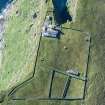
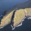
The structure consists of a curved, galleried wall – convex towards the front – barring the neck of the promontory which gives the site its name. The area immediately inland of the wall is now within the grounds of the lighthouse near Barra Head (built in 1833) which is now disused; the promontory fort forms one end of the lighthouse enclosure. The tip of the promontory measures about 42m long by 13m across at the centre; the surface was thought to have been hollowed out at some stage, leaving a ragged parapet of rock around the edges some 1.8 - 3.0m (6 - 10 ft) high [2]. To the author these 'parapets' seem to form a natural amphitheatre and doubt-less partly explain why the site was fortified; several huts could have stood behind the defensive wall, in a fairly sheltered position despite the gales which blow over this high cliff.
At present the wall is about 20.1m (66 ft) in length along the chord of its arc [4, fig. 191] although the south end is almost completely reduced to foundation level and certainly extended a few feet further in the past. Thomas gives the length as 29m (95 ft) but this figure is too great; Anderson's plan [3, fig. 6], made shortly before 1893, shows a length of 21.4m (70 ft) along the same chord. Both plans show how the south-east end curves backwards quite sharply along the edge of the south cliff and ends at a built face which was parallel to the line of the main wall at the opposite end.
The wall stood up to 3.97m (13 ft) high at about 1865 [2] and its outer face stood 2.71m (9 ft) high for much of its length in 1914 [4]; by 1988 however the outer face had been reduced to 2m or less at the centre. Thomas’ elevation of the front face shows several courses of masonry rising above the entrance passage – to almost double its height – but now there are only two. The wall thickness was given as 4.58m (15 ft) [2] but this is now visible only at the entrance passage (near the north-west end) which is 3.97m (13 ft) long (it is possible that the wall is thicker in the centre, as at Rudh an Dunain – NG31 1). Some of the facing stones are very large, one being 2.12m (7 ft) long by 84cm (2 ft 9 in) high. A crudely rebuilt facing has been put on top of the front of the wall to help corral sheep.
A partly lintelled entrance passage – the outer end of which is well preserved – is 3.66m (12 ft) from the north-west end of the wall; it stands 1.60m (5 ft 3 in) high, 66cm (2 ft 2 in) wide at the outer end and has a paved floor. The innermost three-fifths of the left wall has dis-appeared (presumably dismantled) but that on the right is almost complete. In this right wall is a built door-check – 1.04m (3 ft 5 in) from the exterior – with the bar-hole behind it. From this point forward the Iron Age lintels are in situ but the innermost lintel (just behind the door-frame) is not in its original position; it rests on a facing of secondary masonry which has been built against the left wall and which conceals the left door-check while narrowing the outer part of the passage. It comes to a neatly built end 2.1m (7 ft) from the exterior. As noted the later lintel rests on this end, at a slightly higher level than those further out. Thus the secondary masonry has been inserted under the original lintels in the outer part of the passage.
The face of the primary left wall of the passage emerges from behind this later masonry and immediately there is a sharp, well built corner as the face turns into the wall; this is clearly shown on the Commission’s plan. This must be the outer side of a doorway leading directly from the entrance into the basal intra-mural gallery – a feature noted, but not diagnosed as a doorway, by the Commission's investigators [4, 133]. It is also implied in the plan given to Joseph Anderson [3] and in that of Capt. Thomas. A mural gallery connecting directly with the entrance is not so far known in any other semibroch (though it may exist at Dun Grugaig 1 – NG81 1), although it occurs in a few brochs .
At the inner end of the entrance there is now only 79cm (2 ft 7 in) of inner wall-face between its right corner and the edge of the cliff; at the outer end the thickness is about 3.6m (12 ft). Thus the ground plan of this last section of the wall is distinctly wedge-shaped, and the face running along the cliff edge is clear.
In 1915 it could be seen that the promontory wall contained two super-imposed galleries, the lower being about 1.14m (3 ft 9 in) wide and having several of its roofing lintels in position; these last are also shown schematically on Anderson's plan. The outer face of the upper gallery then stood 1.07m (3 ft 6 in) above the lintels at one point. Now the wall is much more broken down and the lintels just mentioned have almost certainly disappeared; a trough along the centre of the wallhead probably marks the position of the gallery but the base of this appears to be lower than the primary entrance lintels – which should be at the same height as those of the Level I gallery. There are now no signs of the face of the upper gallery. The inner face of the main wall is buried so its thickness is not measurable except at the entrance.
Discussion
Excavation might reveal a doorway leading into the rear wallface from the interior and an intra-mural stair rising to its right; however there are no signs of these features at the moment and the fact that the gallery connects with the entrance may mean that no other door into it was needed. One would also expect there to have been a scarcement on the rear wallface (at the level of the lintels of the entrance) but this has probably disappeared. The parallels with Rudh an Dunain (NG31 1) and Dun Grugaig 2 (NG51 1) seem very close and the site is an excellent example of how, at one stage, the sophisticated high, hollow wall of the brochs was used to build simple promontory defences rather than round towers.
The secondary block of drystone masonry which has been inserted into the outer part of the entrance to narrow it suggests that the promontory fort was re-occupied at a later stage of the middle Iron Age, or even later, in the late Iron Age. One could surmise that the inner half of the galleried wall was then taken down to ground level and the outer half rebuilt to make a refurbished stronghold, but only excavation will reveal the true story.
If the hints of an early Iron Age date for the galleried wall at Clickhimin in Shetland (HU 44 1) and Rudh an Dunain in Skye (NG31 1) are applicable to this site, Sron an Duin was probably built in the 6th or even the 7th century BC.
Sources: 1. NMRS site no. NL 58 SW 4: 2. Thomas 1890, 404: 3. Anderson 1893: 4. RCAHMS 1928, 132-33, no. 450: 5. Feachem 1963, 179-80.
E W MacKie 2007
Field Visit (6 May 2010)
The galleried wall that cuts across the tip of Barra Head at the WSW extremity of the precinct around the lighthouse has been heavily mutilated since it was first noted, and further damage has occurred since the visit of Royal Commission investigators in 1915, to the extent that very little trace of the galleries are now visible, and the best preserved sectors of the wall are probably largely rebuilt.
Nevertheless, the wall extends in a shallow arc over a distance of about 25m from the cliff-edge on the N to where the ground falls away in a series of ledges and terraces on the S, measuring up to 4.6m in thickness and standing to a height of 2.45m in nine courses at the point where the southern precinct wall butts up against its outer face. Southwards it thins to 3.7m before petering out in a spread of rubble no more than 2.5m thick. The entrance lies just short of the N end of the wall, which at first sight appears remarkably well-preserved, measuring 4.1m in thickness and rising in a steep batter to a height of 3.2m in a neatly pinned terminal on the cliff edge; the outer face meets the line of the cliff square and turns back at right-angles for a short distance along its lip, thereafter cutting sharply back on itself on a markedly concave line to meet the inner face at the inner end of the entrance passage. The terminal is thus a freestanding block of masonry between the entrance and the cliff. The N side of the entrance passage retains a bar-hole some 2m deep and a door-check set 1.1m back from the outer face. The outer end of the passage is now 0.6m wide and the outermost lintel stands 1.6m above a stone threshold, but the whole of its southern side has been rebuilt and, despite MacKie’s assertion to the contrary (2007, 1169), none of its lintels are in their original positions. The rebuild has taken place in two stages, the latter, as MacKie recognised, represented by a skin of masonry 0.4m thick that now forms the S wall of the roofed passage. Close inspection, however, reveals that the outer face has been rebuilt over a distance of 1.35m beyond this skin, the alternating courses of long slabs and shorter stones contrasting with the character of the more massive pinned boulders of the original face further S. As Foster and Krivanek suggest (in Branigan and Foster, 2000, 133, BY17), the long stones may well be re-used lintels. While there can be no question that this sector of the outer face, and therefore the upper part of the entrance has been extensively rebuilt, it is not certain that this also applies to the corresponding block of walling behind the later drystone skin at the inner end of the passage, which forms a neatly built angle and may be the original E jamb of an entrance into a gallery in the very base of the wall. No more than a groove in the surface of the rubble behind the outer face remains to reveal the gallery’s course, and none of the covering lintels observed in 1915 are now visible. Indeed, comparison with photographs taken in 1915 (IN377 & IN379) shows that a major section of the outer wall-face S of the junction with southern precinct wall has fallen away, taking with it the face of the upper gallery that was then visible.
The interior measures at least 40m from ENE to WSW by a maximum of 15m transversely, but, far from being a naturally formed amphitheatre (MacKie 2007, 1169), the ‘ragged parapet of rock from 6 to 10 feet high all round’ (RCAHMS 1928, 133) is the result of quarrying in 1830-33 for stone to build the lighthouse; at least two drilled shot-holes can be seen in the various rock faces. Although MacKie has suggested that the re-built masonry he noted in the entrance was inserted in the Iron Age (2007, 1169-70), Foster and Krivanek are probably correct in suggesting that most of this work was carried out as restoration with the completion of the lighthouse (2000, 133), but it is unlikely that such a reconstruction would be carried through to include the bar-hole in the N side of the passage. Some of the lower parts of this wall, therefore, may be more ancient, and the contrast between the neatly-built walling of the northern terminal and the rougher more massive construction visible to the S of the entrance, which is also implicit in the depiction of the upper half of the outer wall-face in an undated sketch of the late 19th century by Sir Henry Dryden (SAS27; DC 25546), and indeed a photograph of the face of the upper gallery wall taken in 1915 by Royal Commission investigators (IN377), may not be entirely reliable as a guide to which masonry has been rebuilt.
Visited by RCAHMS SH and SB 7 May 2010
Note (4 November 2014 - 23 May 2016)
This fort occupies a spectacular position on the promontory that projects beyond the precinct wall of the Barra Head lighthouse, perched some 190m above the sea. Its defences comprise a galleried wall up to 4.6m in thickness and about 25m in length, drawn in a gentle arc from the sheer cliff-edge on the N to where the ground falls away in a series of ledges on the S. Though apparently standing 3.2m in height at a squared terminal around the entrance at its N end, with a steeply battered outer face of neatly-pinned masonry, much of this is probably rebuilt, including the lintels of the entrance passage, though its N wall appears to retain a bar-hole and a door-check set 1.1m back from threshold stone on the line of the outer face. The inner end of the S wall of the passage is possibly original and the neatly built angle it preserves may be the E jamb of a doorway into a lower gallery that was still visible with some of its lintels in place in 1915, along with the E face of an upper gallery above it (RCAHMS 1928, 132-3, no.450); no more than a groove now remains to mark the gallery's course through the rubble, as the wall thins to a about 3.7m in thickness and peters out in a mound of stones on the S. The triangular interior measures about 40m from ENE to WSW by a maximum of 15m transversely (0.03ha), but its sunken character is almost certainly the result of quarrying in 1830-33 to provide stone for the lighthouse, which is perhaps also the source of so much of the reconstruction and restoration.
Information from An Atlas of Hillforts of Great Britain and Ireland – 23 May 2016. Atlas of Hillforts SC2482

