
Carradale


No Class (Event)
Site Name Carradale
Classification No Class (Event)
Alternative Name(s) Moineruadh; Carradale Water
Canmore ID 212389
Site Number NR73NE 22
NGR NR 795 382
NGR Description NR c. 795 382
Datum OSGB36 - NGR
Permalink http://canmore.org.uk/site/212389


- Council Argyll And Bute
- Parish Saddell And Skipness
- Former Region Strathclyde
- Former District Argyll And Bute
- Former County Argyll
NR73NE 22 c.795 382
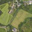
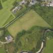
NR 795 382 A series of watching briefs were undertaken between May and September 2000 during a water supply scheme, on a series of terraces running from the lowest adjacent to Carra Water up to the site of the water reservoir.
Only one potentially significant archaeological feature was discovered: a fire-pit in the line of the access road. The sub-circular pit, measuring 1.3 x 1.2m, had been partially truncated by the insertion of a clay field drain. The pit was 0.15m deep, with a flat base and steep sides. It contained three fills, one rich with charcoal, which along with several thin lenses of red sand (probably heat-scorched) suggest it had been utilised as a fire-pit or hearth. (GUARD 864).
Sponsor: West of Scotland Water.
G MacGregor, K McLellan and L H Johnstone 2001.
Watching Brief (May 2000 - September 2000)
NR 795 382 A series of watching briefs were undertaken between May and September 2000 during a water supply scheme, on a series of terraces running from the lowest adjacent to Carra Water up to the site of the water reservoir.
Only one potentially significant archaeological feature was discovered: a fire-pit in the line of the access road. The sub-circular pit, measuring 1.3 x 1.2m, had been partially truncated by the insertion of a clay field drain. The pit was 0.15m deep, with a flat base and steep sides. It contained three fills, one rich with charcoal, which along with several thin lenses of red sand (probably heat-scorched) suggest it had been utilised as a fire-pit or hearth. (GUARD 864).
Sponsor: West of Scotland Water.
G MacGregor, K McLellan and L H Johnstone 2001

