
Balmae House


Building(S) (Period Unassigned), Country House (Period Unassigned), Gate Pier(S) (Period Unassigned), Kennels (Period Unassigned), Policies (Post Medieval), Walled Garden(S) (Period Unassigned)
Site Name Balmae House
Classification Building(S) (Period Unassigned), Country House (Period Unassigned), Gate Pier(S) (Period Unassigned), Kennels (Period Unassigned), Policies (Post Medieval), Walled Garden(S) (Period Unassigned)
Canmore ID 208475
Site Number NX64SE 43
NGR NX 68463 44920
Datum OSGB36 - NGR
Permalink http://canmore.org.uk/site/208475


- Council Dumfries And Galloway
- Parish Kirkcudbright
- Former Region Dumfries And Galloway
- Former District Stewartry
- Former County Kirkcudbrightshire
NX64SE 43 6846 4491
NX64SE 43.01 NX 6858 4480 Balmae House Walled Garden; Buildings
NX64SE 43.02 NX 6850 4497 Balmae House Building
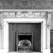
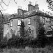
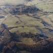
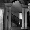
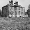
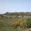
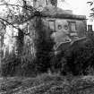
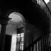
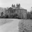
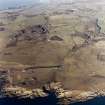
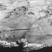
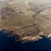
Balmae House has been destroyed and its policies, walled garden and ancillary buildings are either derelict or have been removed, but something of their history can be traced from the 1st and 2nd editions of the OS 6-inch maps (Kirkcudbrightshire 1854, sheet 54; 1896, sheet lviii N.W.) and more recent aerial photography. The entry in the OS ONB (Parish of Kirkcudbright) describes Balmae as a 'handsome mansion house partly of the Corinthian style of architecture. It was built in 1800 by the late Lord Selkirk ... it is surrounded by a small demesne ornamented with plantations etc.' Balmae is shown on Timothy Pont's map (1560-1614), while John Ainslie's map of the Stewartry of Kirkcudbright depicts a large house at Balmae in 1797, and the 'mansion house' was probably a replacement of an earlier building on the site.
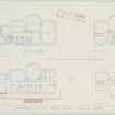
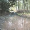
The house (KTA02 88) is depicted on the 1st edition as a long rectangular block aligned from NW to SE (NX 6845 4491), and may have been extended a little further to the SE by the end of the 19th century. This layout is visible on an aerial photograph taken in 1962 (RAF 58/4957, frame no. 0007, 22 February 1962), but by 1988 the site of the house was planted with conifers (All Scotland Survey, 625/88, frame no. 267, 13 June 1988). The 1st edition map shows Dog Kennels to the S (NX 6844 4484), but these do not appear on the 2nd edition map. There are stone gate piers where the drive to the house left the public road (KTA02 433-4)
There is a walled garden to the SE, with a roofed building along the NE wall (NX64SE 43.01, Balmae Gardens Cottage, NX 6866 4480), and the fragmentary remains of a modern building to the NE (NX64SE 43.02).
(KTA02 88, 433-4)
Visited by RCAHMS (DCC) 26 November 2002
T Pont 1560-1614; J Ainslie 1797; ONB 1854
NX64SE 43 68463 44920
Balmae House is depicted on the OS Edition map (Kirkcudbrightshire, sheet LVIII.I, 1908). It was demolished in the early 1960s. Information from RCAHMS (LKFJ), Feb. 2002.
The sundial from Balmae House was moved to Kings Barracks, Townhead NX64NE 87.
NMRS REFERENCE
OWNER: War Department.
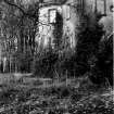
Balmae House which was Category B Listed was blown up 1963 -64. Information from Demolitions catalogue held in RCAHMS library.
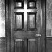
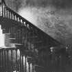
Photographic Survey (November 1959)
Photographic survey of the interior and exterior of Balmae House, Kirkcudbrightshire, by the Scottish National Buildings Record in November 1959.
Photographic Survey (May 1962)
Two photographs of Balmae House, Kirkcudbrightshire, by the Scottish National Buildings Record in May 1962. It was later demolished.

