
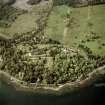
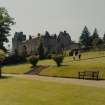
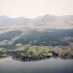
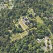
Arran, Brodick Castle, Walled Garden


Walled Garden (Period Unassigned)
Site Name Arran, Brodick Castle, Walled Garden
Classification Walled Garden (Period Unassigned)
Alternative Name(s) Brodick Castle Policies
Canmore ID 206003
Site Number NS03NW 2.01
NGR NS 01671 37876
Datum OSGB36 - NGR
Permalink http://canmore.org.uk/site/206003


- Council North Ayrshire
- Parish Kilbride
- Former Region Strathclyde
- Former District Cunninghame
- Former County Buteshire
NS03NW 2.01 01671 37876
See also:
NS03NW 2.09 01687 37854 Sundial in Walled Garden
NS03NW 2.10 01354 37675 Walled Garden (Kitchen Garden)
NS03NW 2.11 01627 37887 Walled Garden, North West Gate
NS03NW 2.01 01671 37876
NMRS REFERENCE
Drawings on loan to the National Trust fro Scotland 1976
Elevation. Hothouses for garden (paper dated 1859).
Plans and elevations of conservatory. Verso. Plan of conservatory by Butler 1848
Design for sundials - Scottish Guild of handicraft
Conservatory for garden - James Boyle & Son 1882
1 Proposed flower garden in connection with Observatory on site of present garden. W A Nasfield, 3 York Terrace. Regents Park 1852.
2 Plan of details - W A Nasfield, 3 York Terrace. Regents Park 1852.
3 Existing state of ground in vicinity of castle- ditto
4 Section of ground
Plan of grounds - 11th November 1856. Thomas Kyle, Glasgow
(Undated) information in NMRS.
Photographic Survey (6 September 2011)
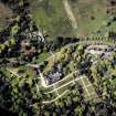
A brief external survey of Brodick Castle and its walled garden was made by RCAHMS survey staff whilst visiting Arran to record other sites for the Threatened Building Survey programme.
Reference (March 2013)
The Walled Garden dates to 1710 (date from stone by north entrance) and was a productive garden until the mid-1760s when it was used as a tree nursery to supply the needs of the estate.
It is of two parts, an upper and lower section separated by a bank, with a further raised terrace against the north wall.
The present layout dates to the 1920s and is a simplified version of that recorded on the 1854 OS map which shows more east-west aligned paths and a summerhouse in the position of the present sundial. The circular sunken garden in the lower section was laid out in 1910.
Information from NTS (SS) March 2013

