
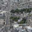
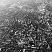
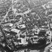
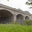
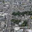
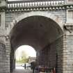
Aberdeen, Denburn Viaduct


Road Bridge (19th Century) (1886)
Site Name Aberdeen, Denburn Viaduct
Classification Road Bridge (19th Century) (1886)
Alternative Name(s) Denburn Road; Lower Denburn Valley
Canmore ID 20116
Site Number NJ90NW 207
NGR NJ 93815 06327
Datum OSGB36 - NGR
Permalink http://canmore.org.uk/site/20116


- Council Aberdeen, City Of
- Parish Aberdeen
- Former Region Grampian
- Former District City Of Aberdeen
- Former County Aberdeenshire
NJ90NW 207 93815 06327
For Rosemount Viaduct (NJ 9341 0646 to 9370 0632), see also NJ90NW 211.
Denburn Viaduct [NAT]
OS 1:1250 map, 1968.
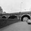
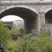
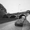
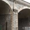
(Location cited as NJ 938 063). The latest of an unusual series of bridges built to open up new areas of the city for development. Built 1886, together with the Rosemount viaduct (NJ90NW 211), by engineer William Boulton; has three segmental skew arches, the central one spanning a railway cutting.
J R Hume 1977.
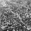
This viaduct carries the main roads of Rosemount Viaduct and Schoolhill over the Denburn Valley railway line which formerly formed part of the main Aberdeen-Inverness line of the Great North of Scotland Rly.
Information from RCAHMS (RJCM), 1 September 1999.

