
Yell, Sands Of Breckon


Settlement (Prehistoric)
Site Name Yell, Sands Of Breckon
Classification Settlement (Prehistoric)
Alternative Name(s) Sands Of Breckin
Canmore ID 20
Site Number HP50NW 11
NGR HP 531 051
NGR Description Centred HP 5315 0515
Datum OSGB36 - NGR
Permalink http://canmore.org.uk/site/20


- Council Shetland Islands
- Parish Yell
- Former Region Shetland Islands Area
- Former District Shetland
- Former County Shetland
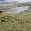
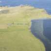
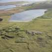
HP50NW 11.00 centred 5315 0515
HP50NW 11.01 HP 5304 0519 Field Survey Area; Excavation
HP 528 053. Evidence of a quartz knapping site was found within the confines of the stone circle, and in conjunction with several structures within the inner ring, strongly suggests a domestic site.
Besides the quartz implements and corresponding waste, several other artifacts of local origin occurred including a split pebble axe of greenstone with Shetland Early Bronze Age affinities.
B Beveridge, 1972.
Field survey and excavation, as a response to continual wind and marine erosion, was carried out at the Sands of Breckon between 1982 and 1983 (HP50NW 1.00 & HP50NW 11.01). The field survey area was over 20ha in extent, and 42 sites of archaeological interest were recognised. HP50NW 11.00 was recorded as a stone settings surrounded by occupational debris (Site 22). Excavation revealed midden deposits of an early Iron Age date and a surface scatter of artefacts of mixed dates. The stone settings were tentatively interpreted as the basal stones of long cists.
Historic Scotland Archive Project (SW) 2002

