
Sgarbach, Auckingill


Standing Stone (Prehistoric)
Site Name Sgarbach, Auckingill
Classification Standing Stone (Prehistoric)
Alternative Name(s) Can 085
Canmore ID 2
Site Number ND36SE 6
NGR ND 3730 6386
Datum OSGB36 - NGR
Permalink http://canmore.org.uk/site/2


- Council Highland
- Parish Canisbay
- Former Region Highland
- Former District Caithness
- Former County Caithness
ND36SE 6 3730 6386.
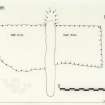
The base of a standing stone which was broken about 1860 is a schist block 4 to 5ft in width and 9ins thick facing NE and SW. It has been excavated to a depth of about 2ft.
Surveyed at 1:2500.
Visited by OS 10 September 1965 and 22 July 1982.
RCAHMS 1911; C E Batey 1982

