
Cullykhan


Battery (18th Century), Castle (Medieval), Promontory Fort (Period Unassigned)
Site Name Cullykhan
Classification Battery (18th Century), Castle (Medieval), Promontory Fort (Period Unassigned)
Alternative Name(s) Castlehead; Troup; Fort Fiddes; Castle Point; Cullychan; Fort Fiddis
Canmore ID 19942
Site Number NJ86NW 1
NGR NJ 8373 6621
Datum OSGB36 - NGR
Permalink http://canmore.org.uk/site/19942


First 100 images shown. See the Collections panel (below) for a link to all digital images.
- Council Aberdeenshire
- Parish Gamrie
- Former Region Grampian
- Former District Banff And Buchan
- Former County Banffshire
NJ86NW 1 8373 6621.
(NJ 8375 6618) Castle (NR) (Site of)
(NJ 8385 6618) Fort Fiddes (NAT)
OS 6" map, Banffshire, 2nd ed., (1905)
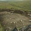
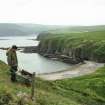
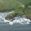
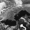
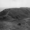
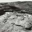
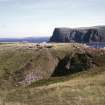
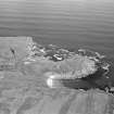
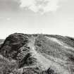
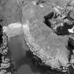
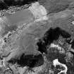
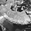
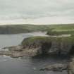
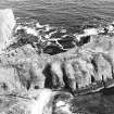
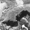
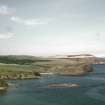
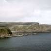
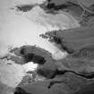
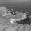
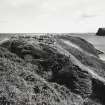
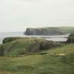
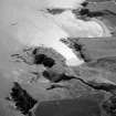
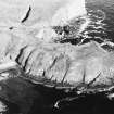
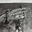
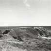
On a promontory, whose sides are formed by precipitous cliffs, and which is linked to the mainland by an isthmus 4ft wide at its narrowest there are three sites:-
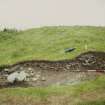
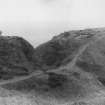
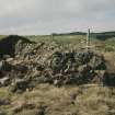
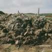
(1) Area centred NJ 8373 6621, the remains of a vitrified fort consisting of a double rampart on the W, a single on the N.
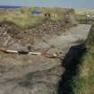
(11) The site of a mediaeval castle at NJ 8378 6617 and consisting of a small keep.
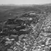
(111) Fort Fiddes, a late 17th century coastal battery, the surviving defence comprising a spread earthen bank about 1.2m maximum height.
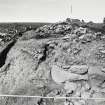
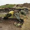
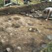
The vitrified fort and medieval castle are being excavated by the Aberdeen College of Education Archaeological Society and the results are to be published in the Trans of the Banff Society.
Resurveyed at 1/2500.
Visited by OS (NKB) 10 February 1965.
J C Greig and R H Cairns 1964.
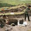
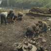
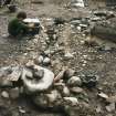
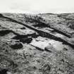
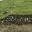
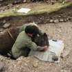
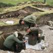
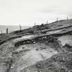
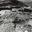
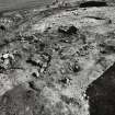
Continuing excavations by the Aberdeen College of Education Archaeological Society, have revealed the footings of a tower 40 x 29ft externally with walls 6ft thick; and Late Bronze Age/Early Iron Age settlement; and occupation associated with the vitrified fort. A structure was uncovered apparently outside the fort, revealing large post-holes and indications of a timber structure. Finds include Neolithic, Iron Age, and Roman pottery, part of a jet bracelet, stone implements, fragments of iron, etc.
J C Greig and R H Cairns 1967.
The Roman pottery consists of indeterminate fragments of coarse ware.
A S Robertson 1970.
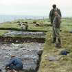
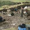
Excavation by J C Greig in 1965-71 aimed to section the W rampart, to open an area within the NE corner of the Iron Age occupation area, and to examine the gate-tower on the 'Knoll'.
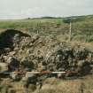
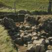
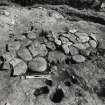
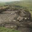
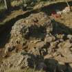
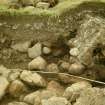
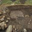
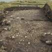
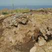
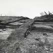
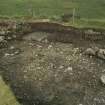
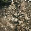
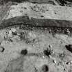
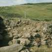
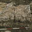
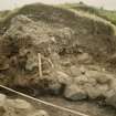
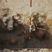
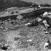
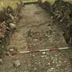
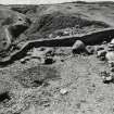
The cutting of the rampart-section revealed the vitrified remains of a timber-laced rampart the foundation-stones timbers of which lie directly upon or are embedded into an earlier occupation horizon. The inner revetting wall was found to comprise blocks of shale, schist and sandstone, and survives to a height of two courses in situ, the large and unburnt schist slabs being undoubtedly derived from the upper courses. The shattered core of this rampart rests directly on a platform of charred longitudinal timbers and comoprises heated shale fragments, disintegrated quartzites and heat-shattered boulders; there was evidently intense heating below the vitrified layer. No definitive evidence was found for the outer revetting-wall but robbing may account for the deep layer of loose brown earthy rubble that was found to contain fragments of vitrified material.
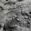
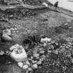
An area of tightly-packed cobbling was found resting on the yellowish clayey subsoil (a) and is itself overlain by a hard-packed occupation-layer (b) containing bronze and iron industrial waste in the form of crucible or funace-working fragments with traces of copper alloys on the surfaces, and iron-working tap-slag. This layer becomes layer (c), is flecked with charcoal and contains numerous calcined fragments of animal bone as well as concentrated areas of heat-shattered firestones. A tightly-packed browny-red clay zone (j) with its associated post-hole suggests either palisade or house-wall remains, as other post-holes have been uncovered from the same horizon. Behind the inner revetting-wall lies a loose brown earthy layer with small angular stones, while immediately above rests a great accumulation of fallen angular shale slabs with air spaces; these gradually merge into a mass of shale rubble and greyish earth (h) which is covered by a grey peaty topsoil (j).
The following building-phases can thus be distinguished from this section:
Phase I: cobbling with associated occupation (a, b and c) containing industrial waste. Further excavation wil probably provide a distinct two-part phasing of this horizon.
Phase IIa: construction of a timber-framed fort above the Phase I occupation level.
Phase IIb: destruction of the timber-framed fort and its resulting vitrifaction, and subsequnt reconstruction.
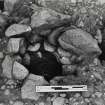
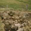
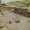
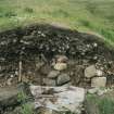
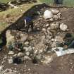
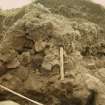
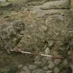
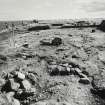
The area-excavation (within the NE corner of the Iron Age occupation area) revealed a Phase I domestic structure the floor of which comprised a tightly-packed cobbled surface, upon which lies a hard-packed grey occupation-horizon covered by a much loosed dark, charcoal-flecked stratum with a well-constructed circular hearth, the slightly raised kerb of which enclosed a flat area of what appeared to be crushed and heated conglomerate. Finds from the occupation-levels included pottery rims of distinctive form, wall-sherds of hard and extremely gritty type, a tanged chisel of Late Bronze Age type, and fragments of jet bangls.
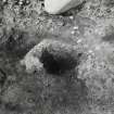
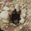
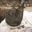
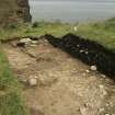
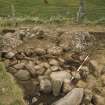
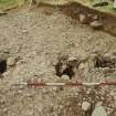
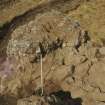
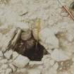
Work on the Knoll revealed the ground plan of a massive timber gate-tower, the mode of construction of which entailed digging four rectangular trenches into which were set pairs of drystone post-sockets (measuring on average 0.61m in depth and 0.41m in width) to support what was evidently a substantial rectangular gatehouse. The massive timber uprights were set into these holes and the spaces between wood and stone were filled with flat, narroiw packing-stones and clay. A section across post-holes 2 and 3 revealed a perfectly-preserved oak stump measuring 0.46m in height and 0.41m in diameter. Post-socket 1 implies some form of bracing-timber, and sockets 6 and 10 suggest a funnel-shaped timber-palisade entrance. The timber slot found in direct relationship to post-holes 7 and 8 is the only evidence of the method of gate-construction. It was noted that the primary cobbled or pebbled horizon (over which lay a sterile burnt timber layer) had been taken over the edge of the post-sockets and probably continued to the sides of the timber uprights. Partial excavation to the north of the gateway exposed a series of post-holes set into a hard-beaten clay foor, as well as collapsed pebble-and-clay walling and a largeflat-stoned hearth surrounded by a concentrated carbon deposit from which was recovered a fragment of jet bracelet.
The post-vitrification reconstruction (Phase III) of the site has been suggested on the evidence of:
1. foundation walling in the gateway area,
2. Late Roman (3rd and 4th centuries AD) sherds from the upper horizon on the Knoll, and
3. radiocarbon date BM-445.
The following radiocarbon determinations have ben obtained:
carbon from burnt timber layer on the Knoll 106 +/- 51 bc (BM-443)
sample of charred longitudinal timber platform (phase IIb) 1186 +/- 60 bc (BM-444)
sample from wooden object (phase III) 317 +/- 40 ad (BM-445)
sample of carbon from occupation level (phase I) 387 +/- 65 bc (BM-446)
section of oak stump from post-socket (phase I) 397 +/- 59 bc (BM-639)
J C Greig 1971.
The earliest phase of the fortification of this site seems to have been a wooden palisade, as at Craigmarloch Wood; in this case it was probably associated with a massive wooden gate-tower on the neck of the promontory, one of the oak post-butts of which gave a date of 397 +/- 59 bc. The timber-framed stone fort was later but wood from its wall core gave an age of 1186 +/- 60 bc. Charcoal from the main occupatiuon layer, which ran under this wall, gave an age of 387 +/- 65 bc.
The history of the use of this site could well start in the 7th century BC, judging from the Late Bronze Age tanged chisel found in this layer. Its use may have continued into post-Roman/early Pictish times, judging from the discovery of Late Roman pottery and a date from the same horizon of 317 +/- 40 ad.
E W MacKie 1976.
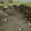
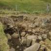
The primary defences lay at the landward end of the promontory and comprised at least one line of timber palisade. This was superseded in about the 4th century BC by a vertical wall of stone and timber with an impressive gateway set back between in-turning sections of walling. Stylistically, the fort displays strong affinities with north German examples, a connection emphasised by the discovery of artefacts of German origin in the area behind the rampart. Here, too, there was considerable evidence for metalworking on the site. The sequence of defences was completed probably in thre later 1st century BC by the construction further to the E of a timber-laced rampart. This had been destroyed by a major conflagration. In the Pictish period, two flat-bottomed ditches were cut across the middle of the promontory, while in the 13th century the site was re-occupied as the location of the castle of the Troup family. It was finally re-fortified in the 18th century as an artillery defence called Fort Fiddes.
R D Oram 1997.
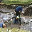
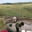
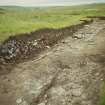
(Location cited as NJ 8377 6619: nominated as Site of Regional Significance). This monument is situated on a promontory at and altitude of 30m OD. Dendrochronological samples have been taken and dates are awaited.The larger flat area of the promontory is shown on an estate map as having been ploughed in the 19th and earlier 20th centuries. A number of the excavation trenches were subsequently backfilled, the remainder being left open at the request of the landowner, the late Watt Taylor. Wood, soil and environmental (pollen) samples were taken from the site by Dr H McKerrell but were destroyed due to laboratory contamination.
[Air photographic imagery and radiocarbon dates listed].
NMRS, MS/712/35 and MS/712/36.
Publication Account (1986)
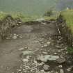
Excavation on this low coastal headland of conglomerate has revealed an extraordinarily long sequence of occupation. The defensive properties of the site are emphasised by the walk to it, along a narrow knife-edged isthmus, nowhere more than 4m wide.
The initial defence was on the Knoll, the landward point of the promontory, and consisted of at least one palisade, probably built in the early 1st millennium BC. Around the 4th century BC, the Knoll was refortified with a vertical wall of stone and timber and an elaborate gateway, similar to some German forts. Considerable evidence of metalworking as well as objects such as an imported Gennan chisel lay behind this defence. The next phase occurred sometime after 100 BC, further east (between the Knoll and the Medieval castle), and consisted of a timber-laced rampart which was destroyed by a fIerce fire. A fourth phase saw the cutting of two flat-bottomed ditches across the promontory at the junction of the Knoll and the main area.
From the objects recovered in the excavation and the defensive phases outlined above, it is possible to summarise the prehistoric occupations as a late bronze-age refuge, an iron-age citadel and an early Pictish fort. Subsequently the promontory was used for a medieval castle and for Fort Fiddes, an 18th century shore defence.
Information from ‘Exploring Scotland’s Heritage: Grampian’, (1986).
Publication Account (1996)
Excavation on this low coastal headland of conglomerate has revealed an extraordinarily long sequence of occupation. The defensive properties of the site are emphasised by the walk to it, a long a narrow knife-edged isthmus, nowhere more than 4m wide.
The initial defence was on the Knoll, the landward point of the promontory, and consisted of at least one palisade, probably built in the early 1st millennium BC. Around the 4th century BC, the Knoll was refortified with a vertical wall of stone and timber and an elaborate gateway, similar to some German forts. Considerable evidence of metalworking as well as objects such as an imported German chisel lay behind this defence. The next phase occurred sometime after 100 BC, further east (between the Knoll and the medieval castle), and consisted of a timber-laced rampart which was destroyed by a fierce fire. A fourth phase saw the cutting of two flat-bottomed ditches across the promontory at the junction of the Knoll and the main area.
From the objects recovered in the excavation and the defensive phases outlined above, it is possible to summarise the prehistoric occupations as a late bronze-age refuge, an iron-age citadel and an early Pictish fort. Subsequently the promonrory was used for a medieval castle and for Fort Fiddes, an 18th-century shore defence.
Information from ‘Exploring Scotland’s Heritage: Aberdeen and North-East Scotland’, (1996).
Note (23 April 2015 - 25 October 2016)
The presence of a fort with a vitrified wall was first noted in 1777 on this promontory forming the N side of Cullykhan Bay (Williams 1777, 67-9), but it is not shown on the 1st edition OS 25-inch map as such, and is otherwise noted only for also being the site of a medieval castle and a later artillery fortification. The promontory is girt with steep slopes and cliffs, its summit measuring 260m in overall length by a maximum of some 70m transversely at the W end, little more than 20m in the central sector occupied by the stump of the medieval keep, and widening to 47m at the roughly square E end; as defined, it is likely that it was once a promontory fortification enclosing up to 1ha. Apart from the medieval keep and the artillery fortification that occupied the seaward end of the promontory, the line of a grass grown rampart containing vitrified stone can be traced round at least two sides of the W or landward end, on the W and N respectively, perhaps forming a rather smaller rectilinear enclosure measuring internally about 54m from E to W by from 30m to 48m transversely (0.25ha). Excavations directed by Colvin Greig 1963-72 focused on this W portion and the keep, and revealed a complex history of occupation and fortification, though in the absence of new radiocarbon dates the precise chronology remains unclear, and the detail of the stratigraphic sequence is not yet published. Nevertheless, the burnt and partly vitrified timber-laced rampart overlay earlier deposits from which one charcoal sample returned a date of AD 420-640 (GU-2094), probably indicating that this phase of the fortifications was constructed in the early medieval period. Excavations on a knoll prolonging the neck of the promontory on the W, however, also uncovered a gateway in a stone wall with substantial vertical timbers set in its external face, the stumps of several of which survived in situ; one of these returned an earlier date correcting to 800-200 BC (BM-639). It seems to represent an earlier fortification on the promontory with an elaborate entrance. A timber palisade was also excavated immediately east of this, though whether as postulated by some writers (MacKie 1976, 219-20) there was ever a palisaded phase as such is uncertain. Occupation deposits sealed beneath the ramparts also produced earlier Iron Age dates, and there was extensive evidence of iron and copper alloy metalworking. The broad span of the radiocarbon dates obtained, and the Late Bronze Age chisel from deposits beneath the burnt rampart may indicate the defensive sequence is more complex than is currently understood (see Greig 1970; 1971; 1972), but there is no reason why it should represent continuous occupation of the promontory over such a long period.
Information from An Atlas of Hillforts of Great Britain and Ireland – 25 October 2016. Atlas of Hillforts SC2982

