
South Ythsie


Cairn (Neolithic) - (Bronze Age), Ring Cairn (Neolithic) - (Bronze Age)(Possible), Stone Circle (Neolithic) - (Bronze Age)
Site Name South Ythsie
Classification Cairn (Neolithic) - (Bronze Age), Ring Cairn (Neolithic) - (Bronze Age)(Possible), Stone Circle (Neolithic) - (Bronze Age)
Canmore ID 19809
Site Number NJ83SE 12
NGR NJ 8849 3039
Datum OSGB36 - NGR
Permalink http://canmore.org.uk/site/19809


- Council Aberdeenshire
- Parish Tarves
- Former Region Grampian
- Former District Gordon
- Former County Aberdeenshire
NJ83SE 12 8849 3039.
(NJ 8849 3039) Stone Circle (NR).
OS 6" map, (1959)
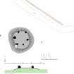
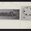
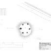
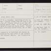
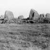
A stone circle 27ft in diameter, consisting of six (Coles 1902) - the Ordnance Survey Name Book (ONB, 1868) states seven - upright stones from 2ft 6ins to 5ft 7ins in height, set on a clearly defined mound some ft above the surrounding ground level. In the interior is a biggish stone, which is loose and easily moved. Farther within is a single earth-fast narrow stone, set on edge.
F R Coles 1902; Name Book 1868.
A stone circle, generally as described and planned by Coles. Stone clearance has been added to the interior thus obscuring the internal details.
Resurveyed at 1:2500.
Visited by OS (RL) 6 April 1972.
Field Visit (16 May 2005)
This cairn incorporates a ring of six upright stones and lies at the edge of an arable field in gently rolling ground. Now largely grass-grown, the cairn is flat-topped and measures 14.5m in diameter, ranging in height from 0.5m on the NE to 1.2m on the SW. The stones are all thick blocks and, with one exception on the SE, are set along the edge of the summit of the cairn. They appear to be graded in height, rising to 1.53m in height on the SW, where the external face of the tallest stone has been split vertically. Coles records this split on plan, together with what may be a kerbstone of an internal court, and he refers to the latter in his accompanying description of the site as ‘a single earth-fast narrow stone set on edge…in a position suggestive of its being a part of a central setting of about 6 feet in diameter’ (Coles 1902a, 524-6).
Visited by RCAHMS (ATW,ARG) 16 May 2005
Measured Survey (16 May 2005)
RCAHMS surveyed South Ythsie cairn on 16 May 2005 with plane table and alidade producing a plan and section at a scale of 1:100. The survey drawing was later used as the basis for an illustration redrawn in vector graphics software at a scale of 1:250.

