
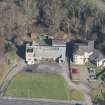
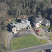
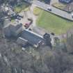
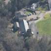
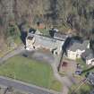
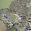
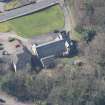
Cardross, Main Road, Geilston Hall


Drill Hall (19th Century), Drill Hall (First World War), Hall (19th Century)
Site Name Cardross, Main Road, Geilston Hall
Classification Drill Hall (19th Century), Drill Hall (First World War), Hall (19th Century)
Alternative Name(s) Drill Hall
Canmore ID 197606
Site Number NS37NW 32
NGR NS 34068 78006
Datum OSGB36 - NGR
Permalink http://canmore.org.uk/site/197606


- Council Argyll And Bute
- Parish Cardross (Argyll And Bute)
- Former Region Strathclyde
- Former District Dumbarton
- Former County Dunbartonshire
NMRS REFERENCE:
Architects: John Honeyman & Keppie 1889.
Project (March 2013 - September 2013)
A project to characterise the quantity and quality of the Scottish resource of known surviving remains of the First World War. Carried out in partnership between Historic Scotland and RCAHMS.
Note (23 October 2013)
Geilston Hall is depicted on the 2nd edition of the OS 25-inch map annotated 'Geilston Hall (Drill Hall)'. Not listed by Osborne, it is possible is was still in use as a drill hall by the First World War.
Information from RCAHMS (AKK) 23 October 2013.

