 |
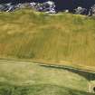
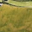
On-line Digital Images |
DP 091673 |
RCAHMS Aerial Photography Digital |
Oblique aerial view of the cropmarks of the ring ditch, rig and possible round house, looking to the NNW. |
22/7/2010 |
Item Level |
|
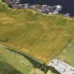 |
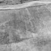
On-line Digital Images |
DP 091674 |
RCAHMS Aerial Photography Digital |
Oblique aerial view of the cropmarks of the ring ditch , rig and possible round house, looking to the NW. |
22/7/2010 |
Item Level |
|
 |
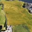
On-line Digital Images |
DP 091675 |
RCAHMS Aerial Photography Digital |
Oblique aerial view of the cropmarks of the ring ditch, rig and possible round house, looking to the WNW. |
22/7/2010 |
Item Level |
|
 |
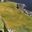
On-line Digital Images |
DP 091676 |
RCAHMS Aerial Photography Digital |
Oblique aerial view of the cropmarks of the ring ditch, rig and possible round house with Mains of Melrose in the foreground, looking to the W. |
22/7/2010 |
Item Level |
|
 |
On-line Digital Images |
DP 091678 |
RCAHMS Aerial Photography Digital |
Oblique aerial view of the cropmarks of the ring ditch, rig and possible round house, looking to the SSE. |
22/7/2010 |
Item Level |
|
 |
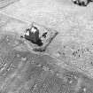
On-line Digital Images |
SC 1936878 |
Records of Aberdeen Aerial Surveys, Aberdeen, Scotland |
Mains of Melrose, ring-ditch: oblique air photograph. |
9/8/1977 |
Item Level |
|
 |
On-line Digital Images |
SC 1937071 |
|
Inchdrewer Castle: aerial view. |
9/8/1977 |
Item Level |
|
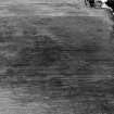 |
On-line Digital Images |
SC 2006412 |
Records of Aberdeen Aerial Surveys, Aberdeen, Scotland |
Mains of Melrose, ring-ditch: aerial photograph |
9/8/1977 |
Item Level |
|
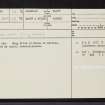 |
On-line Digital Images |
SC 2376680 |
Records of the Ordnance Survey, Southampton, Hampshire, England |
Mains Of Melrose, NJ76SW 12, Ordnance Survey index card, page number 1, Recto |
1958 |
Item Level |
|
 |
On-line Digital Images |
SC 2376681 |
Records of the Ordnance Survey, Southampton, Hampshire, England |
Mains Of Melrose, NJ76SW 12, Ordnance Survey index card, Recto |
1958 |
Item Level |
|


