
Knowe Of Makerhouse


Burnt Mound (Prehistoric)
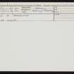
Site Name Knowe Of Makerhouse
Classification Burnt Mound (Prehistoric)
Canmore ID 1893
Site Number HY22SE 6
NGR HY 29359 21141
Datum OSGB36 - NGR
Permalink http://canmore.org.uk/site/1893


- Council Orkney Islands
- Parish Birsay And Harray
- Former Region Orkney Islands Area
- Former District Orkney
- Former County Orkney
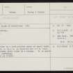
Field Visit (14 June 1929)
Mound of burnt stones, about 250 yds S of the farm-house of Gelderhouse.
RCAHMS 1946, visited 14 June 1929
OS 6" map (1903)
Note (20 March 1967)
HY22SE 6 2935 2114.
(HY 2935 2114) Knowe of Makerhouse (NR)
OS 6" map, Orkney, 2nd ed., (1903).
Mound of burnt stones.
RCAHMS 1946.
Scheduled.
AMs Scot. 1961, 30
Field Visit (16 May 1967)
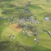
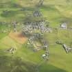
Knowe of Makerhouse is a turf-covered mound of small burnt stones and earth, c.24.0m in diameter and 1.7m high, situated in a marshy plain close by a stream. It is greatly mutilated by quarrying.
Resurveyed at 1/2500.
Visited by OS (NKB) 16 May 1967.

