 |
On-line Digital Images |
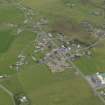
DP 055483 |
RCAHMS Aerial Photography Digital |
Oblique aerial view centred on the village, taken from the S. |
24/9/2008 |
Item Level |
|
 |
On-line Digital Images |
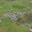
DP 055484 |
RCAHMS Aerial Photography Digital |
Oblique aerial view centred on the village, taken from the E. |
24/9/2008 |
Item Level |
|
 |
On-line Digital Images |
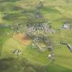
DP 083328 |
RCAHMS Aerial Photography Digital |
General oblique aerial view centred on Dounby during the Orkney West Mainland Agricultural Society Show, taken from the SW. |
6/8/2009 |
Item Level |
|
 |
On-line Digital Images |
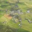
DP 083329 |
RCAHMS Aerial Photography Digital |
General oblique aerial view centred on Dounby during the Orkney West Mainland Agricultural Society Show, taken from the SW. |
6/8/2009 |
Item Level |
|
|
Manuscripts |
MS 7675 |
Orkney Archaeological Trust |
Report: 'Dounby Quilco Archaeological Evaluation' |
11/2006 |
Item Level |
|
|
Manuscripts |
MS 7693 |
Orkney Research Centre for Archaeology (ORCA) |
Report: 'Archaeological Assessment: Makerhouse Development, Dounby, Orkney' |
11/2007 |
Item Level |
|
 |
On-line Digital Images |
SC 2340063 |
Records of the Ordnance Survey, Southampton, Hampshire, England |
Knowe Of Makerhouse, HY22SE 6, Ordnance Survey index card, Recto |
1958 |
Item Level |
|
 |
On-line Digital Images |
SC 2340064 |
Records of the Ordnance Survey, Southampton, Hampshire, England |
Knowe Of Makerhouse, HY22SE 6, Ordnance Survey index card, Recto |
1958 |
Item Level |
|
|
All Other |
551 166/1/1 |
Records of the Ordnance Survey, Southampton, Hampshire, England |
Archaeological site card index ('495' cards) |
1947 |
Sub-Group Level |
|


