
Unst, Soerhouse


Farmstead (Period Unassigned)
Site Name Unst, Soerhouse
Classification Farmstead (Period Unassigned)
Canmore ID 188663
Site Number HP60SW 47
NGR HP 61589 02940
Datum OSGB36 - NGR
Permalink http://canmore.org.uk/site/188663


- Council Shetland Islands
- Parish Unst
- Former Region Shetland Islands Area
- Former District Shetland
- Former County Shetland
HP60SW 47 6150 0294
A farmstead comprising two unroofed buildings, one of which is L-shaped, and three enclosures is depicted on the 1st edition of the OS 6-inch map (Orkney and Shetland (Shetland) 1881, sheet viii) and on the current edition of the OS 1:10000 map (1973), where the largest enclosure is shown as incomplete.
Information from RCAHMS (SAH) 6 February 2001
Field Visit (January 1970 - December 1991)
A survey of deserted settlements in Unst by June Owers. The survey includes photographs, sketches and historical information.
Field Visit (25 April 2010)
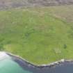
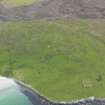
This farmstead, which is situated in semi-improved pasture about 110m NW of a similar, but smaller, holding (HP60SW 48), comprises a building and two trapezoidal enclosures to its E and S respectively. The building measures about 11m from N to S by 5m transversely over rubble walls standing to wall-head height. There is a central doorway flanked by windows in the E side and possibly the remains of a fireplace at the S end. An outshot is attached to the N end of the building and projects W, lending the whole an L-shaped plan. This outshot measures about 12m from E to W by 5m over rubble walls and contains two compartments.
The building and its outshots are depicted unroofed on both the 1st and 2nd editions of the OS 6-inch map (Shetland 1882 and 1902, Sheet VIII).
Srp Note (27 September 2011)
A plan of Soerhouse was sketched by June Owers in her survey of abandoned settlements on Unst (1984).
Information from RCAHMS (BRW) 27 September 2011

