
Castle Fraser Policies, John Bell's Stone


Commemorative Stone (Period Unassigned), Rig And Furrow (Medieval) - (Post Medieval), Standing Stone (Prehistoric)(Possible)
Site Name Castle Fraser Policies, John Bell's Stone
Classification Commemorative Stone (Period Unassigned), Rig And Furrow (Medieval) - (Post Medieval), Standing Stone (Prehistoric)(Possible)
Alternative Name(s) Castle Fraser Estate; John Bell Field
Canmore ID 18721
Site Number NJ71SW 5
NGR NJ 72115 12719
Datum OSGB36 - NGR
Permalink http://canmore.org.uk/site/18721


- Council Aberdeenshire
- Parish Cluny
- Former Region Grampian
- Former District Gordon
- Former County Aberdeenshire
NJ71SW 5 72115 12719
(NJ 7212 1270) John Bell (NR)
OS 6" map, (1959)
Stone [NAT]
OS 1:10,560 map, 1970.
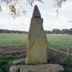
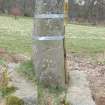
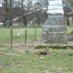
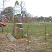
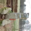
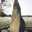
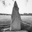
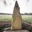
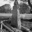
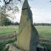
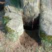
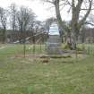
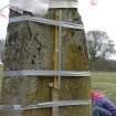
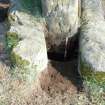
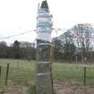
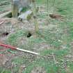
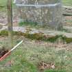
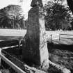
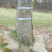
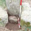
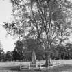
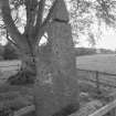
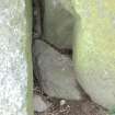
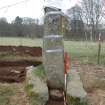
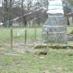
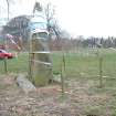
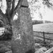
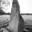
An upright and partly hewn stone surmounted by a ball, erected at the time of the building of Castle Fraser (1617 - see NJ71SW 6.00) to commemorate the architect John Bell.
Name Book 1866.
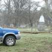
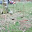
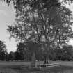
This standing stone is situated some 200m NW of Castle Fraser (NJ71SW 6.00). Although traditionally assumed to have been erected about 1617 (at the time of the completion of the building of Castle Fraser and to commemorate the architect John Bell), there is good reason to consider this stone a genuine prehistoric monolith. The stone is of similar type to those forming the flankers of the recumbent stone circle (NJ71SW 3) that is situated some 650m further to the WSW, while it seems unlikely (given the scale, elaboration and expense of Castle Fraser itself) whether an unhewn erratic would be considered adequate to commemorate its final architect. It is more probable that the commemoration of John Bell is indicated by no more than the small granite pyramid (originally topped by a ball) that has been placed on top of the stone.
Visited by RCAHMS (JRS, ARW), 18-19 October 1994.
NMRS, MS/820.
Field Visit (May 1996 - May 1996)
A023 Standing Stone.
NJ 7212 1270
Situated in John Bell Field or Home Park to the north-west of the Castle is a standing stone. This monument is traditionally supposed to have been erected in 1617 to commemorate John Bell (Architect). There is however a likelihood that the stone may be of prehistoric origin as it is of similar size to the stones in the prehistoric stone circle at NJ 71 SW 3 situated 700m to the west (outwith site). While it is possible to state this stone is of a similar nature to those of clearly prehistoric date, is impossible to say without further investigation whether the stone's setting is also prehistoric. A later stone pyramid (originally a ball) has been mounted onto the stone presumably at the time of the monument's dedication to John Bell.
Field walking, 24.5.96. Ordnance survey Present Edition 1:10000 map sheet NJ 71 NW. RCAHMS. NMRS NJ 71 SW 5.
(CAF96 A023) Information from (BNM) March 2014
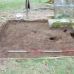
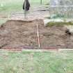
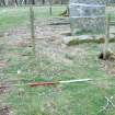
Excavation (1 April 2009 - 2 April 2009)
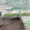
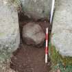
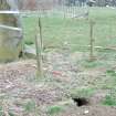
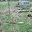
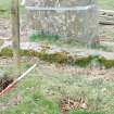
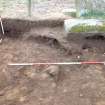
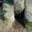
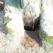
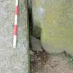
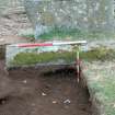
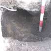
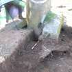
NJ 7212 1270 This standing stone is a natural boulder with a pyramidal capstone, traditionally regarded as a memorial stone to John Bell, architect of the upper works at Castle Fraser in the early 17th century. However, its proximity to the Castle Fraser recumbent stone circle and its two outlying standing stones (NJ71SW 6) suggests that this was a prehistoric monument later re-used as a memorial.
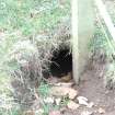
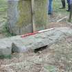
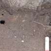
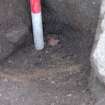
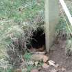
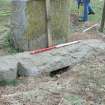
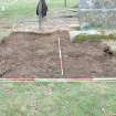
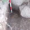
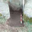
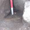
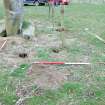
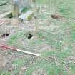
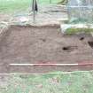
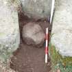
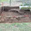
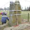
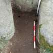
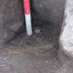
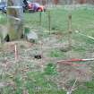
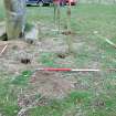
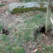
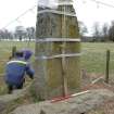
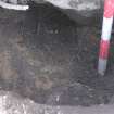
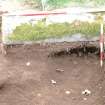
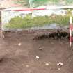
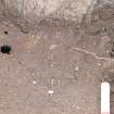
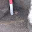
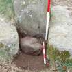
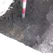
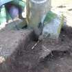
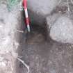
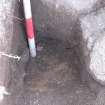
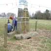
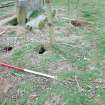
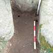
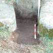
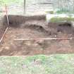
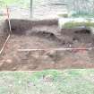
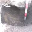
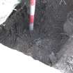
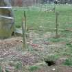
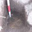
As a result of rabbit burrowing stabilisation was required, providing the opportunity for a small excavation. This
revealed the original socket for the stone but no prehistoric material within it. However, a furrow of probable medieval/post-medieval rig and furrow cultivation was revealed, beside the stone but respecting it. This suggests that it is likely to have been standing before the improvements of the 18th century and may indeed be a prehistoric monument. It is shown on an Estate map of 1788 in an open field, only later being emphasised as a landscape feature in a small group of trees. There is some indication that the pyramidal capstone and a
ball finial (now missing) may have been added at the end of the 18th century. This work was carried out on 1–2 April 2009.
Report: Aberdeenshire SMR, NTS and RCAHMS
Funder: The National Trust for Scotland
HK Murray and JC Murray – Murray Archaeological Services Ltd

