
Nether Coullie


Recumbent Stone Circle (Bronze Age), Stone Circle (Neolithic) - (Bronze Age)
Site Name Nether Coullie
Classification Recumbent Stone Circle (Bronze Age), Stone Circle (Neolithic) - (Bronze Age)
Alternative Name(s) Nether Coulie
Canmore ID 18657
Site Number NJ71NW 11
NGR NJ 7098 1564
Datum OSGB36 - NGR
Permalink http://canmore.org.uk/site/18657


- Council Aberdeenshire
- Parish Monymusk
- Former Region Grampian
- Former District Gordon
- Former County Aberdeenshire
NJ71NW 11 7098 1564.
(NJ 7098 1566) Stone (NAT)
OS 6" map, (1959)
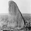
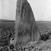
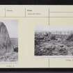
Prior to c.1860 a stone circle 60-90' (18.3-27.4m) in diameter, consisting of nine stones surrounding a tenth, stood in the second field north-west of Nether Coullie farmhouse, about 140yds (128m) north of the farm road which runs E-W. The only stone now remaining is the former central one, which is 8'9" (2.67m) high.
F R Coles 1901.
A stone circle 75-80' (22.9-24.4m) in diameter, consisting of eight stones, stood prior to c.1876, when it was taken down by the farmer, in Standing Stones field, Nether Coullie. The west pillar stone some 9' (2.74m) high, was left in situ, as was the east pillar. The latter, however, which had fallen flat, was covered up with extra soil, and its position was not located. The recumbent stone was apparently removed prior to the destruction of the circle, as it was missing at that time (c.1876).
Two of the stones (each about 3'6" (1.06m) high x 3'6" (1.06m) broad) removed from the circle, may still be seen in the dyke bounding the road to the south of the site.
J Ritchie 1917.
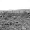
All that remains of this stone circle is a single upright stone (facing NNE-SSW and measuring 2.7m high, 1.8m maximum width and 0.4m thick). The orientation of the stone suggests that it is the W pillar and not the central stone as stated by Coles (1901). Adjacent and on the NE side is a vague circular rise slightly exceeding 20m in diameter which may indicate the former extent of the circle.
The two stones (both measuring c.1.0m x 0.9m x 0.8m) alleged by Ritchie (1917) to have been removed from the circle are still at the side of the track to the S and others showing drill holes occur along the roadside to the E.
Revised at 1/2500.
Visited by OS (ISS) 20 July 1973.
(Listed as a recumbent stone circle).
H A W Burl 1973.
No change to previous field report.
Visited by OS (NKB) 19 August 1976.
All that remains of this stone circle is a single fallen stone; it measures 3.1m in length by 1.6m in breadth and at least 0.3m in thickness.
Visited by RCAHMS (JRS), 22 October 1996.
(Name cited as Nether Coulie).
NMRS, MS/712/66.
Publication Account (2011)
Since the late 19th century a single standing stone is all that has remained to mark the site of this stone circle, and even this has now fallen. Measuring 3.1m in length, it has been an impressive monolith, but curiously neither it nor its parent circle is shown on the 1st edition of the OS 6-inch map (Aberdeenshire 1869, lxiv). Situated in a field on the rising ground west-northwest of Nether Coullie, it is perhaps the exception that proves the general rule that in enclosed farmland upright stones that do not appear on the 1st edition OS map are more recently erected rubbing stones (Gannon et al 2007, 68). In this case, however, the sources are insistent, if slightly conflicting. Coles, drawn to the site by a passing reference in a history of Monymusk Priory (MacPherson 1895, 10–11), elicited merely that the surviving monolith had apparently stood within a circle of nine stones until about 1860 (Coles 1901, 203). However, James Ritchie seems to have tapped a much more detailed vein of local knowledge, visiting the site of the circle with the tenant, William Connon, who put the clearance of the last stones some 40 years earlier. Ritchie’s account was published in 1917, though he had been collecting information on stone circles since at least the turn of the century. Coles’ date of about 1860, however, at least puts the demolition of the circle before the OS surveyors mapped the area in 1864–7. According to Connon, the circle measured between 22m and 24m in diameter and comprised eight stones, though in common with Coles’ source he put the surviving stone in the centre. Nevertheless, as Ritchie got Connon to point out the positions of the various stones that had been removed, he concluded that this had been a recumbent stone circle, the surviving stone being the western flanker of the setting, its eastern pair apparently lying buried a little to the south-east (Ritchie 1917, 43–5). Their attempts to locate this buried stone by probing ended in failure, but Ritchie photographed two blocks in the field boundary to the south that were said to have been taken from the circle, and several others there show evidence that they have been blasted. Alexander Keiller followed Ritchie’s interpretation (1934, 21), and Nether Coullie has been accepted as the site of a recumbent stone circle ever since (Burl 1970, 60, 68, 78; 1976a, 352, Abn 81; 2000, 421, Abn 84; Barnatt 1989, 293, no. 6:66; Ruggles 1984, 60; 1999, 187). The evidence, however, cannot be regarded as conclusive, and in view of the wide range of other types of circle that the present survey has recorded in the North-east, Nether Coullie has been rejected until further evidence is brought forward to show that it once included a recumbent.
Field Visit (6 October 2015)
This ring was rejected as a recumbent stone circle by RCAHMS (Welfare 2011, 533-4), as the evidence then available was inconclusive. However, it is now possible to cite new information which confirms that it belongs to this class.
The map of the Monymusk estate, prepared by Alexander Ogg in 1846, identifies a ring at this location as a 'Druidical Circle'; and in so doing, Ogg depicts it as a semicircle of individual dots with a broad bar on the SW - an intelligent means of representing a circle of orthostats with a recumbent setting flattening one arc. Tillyfourie (NJ61SW 3), another recumbent stone circle on the estate, is represented in the same way.
Although Coles had understood his informant to mean that the one surviving stone had stood at the centre of the ring, Ritchie eventually concluded from what he learned from William Conlon (who had probably also been Coles' source, as he had been farming at Nether Coullie since at least 1871) that 'the circle had really been one of the usual recumbent-stone type, and that the tall stone now remaining was the west pillar' (Ritchie 1917, 44). However, re-examination of the fallen stone in conjunction with Ritchie's photographs (SC681584 and SC681701) not only suggests that it has simply slumped forward on to its face, but that it must have been the east flanker (and not as he supposed the west flanker) due to the contrast it exhibits between the strongly curved outline on the one side and a straight edge on the other (Welfare 2011, 121).
Ritchie's account also refers to two stones that were removed to the edge of the field at the time of the ring's demolition (Ritchie 1917, 44, 45). They still remain where he photographed them 2m N of the track and 107mm SSW of the fallen flanker. The west stone (A), which is roughly triangular in shape, measures 0.9m high by 1.43m broad and 0.75m thick, while its neighbour to the east (B) is subrectangular and measures 0.75m high by 0.83m broad and 0.96m thick. These are a fine grained, dark rocks that appear to differ geologically from the flanker, which is a fine grained grey granite with quartz veins, measuring 3.2m long by 2m broad and at least 0.3m thick.
Visited by HES (ATW and AMcC), 6 October 2015.
Measured Survey (6 October 2015)
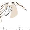
HES surveyed the remains of the stone circle at Nether Coullie with GNSS on 6 October 2015. The GNSS linework was used to create a plan in vector graphics software that indicates the locations of the surviving stones at a scale of 1:1000.

