
Lawfolds


Barrow (Prehistoric), Rig And Furrow (Medieval)
Site Name Lawfolds
Classification Barrow (Prehistoric), Rig And Furrow (Medieval)
Canmore ID 18114
Site Number NJ62NE 38
NGR NJ 69771 27875
Datum OSGB36 - NGR
Permalink http://canmore.org.uk/site/18114


- Council Aberdeenshire
- Parish Rayne
- Former Region Grampian
- Former District Gordon
- Former County Aberdeenshire
NJ62NE 38 6976 2785
Ring-ditch with thin ring; possible timber hut.
Air photographic imagery: RCAHMSAP 1976 and CUCAP CAF 44, flown 21 July 1976.
NMRS, MS/712/59.
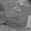
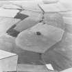
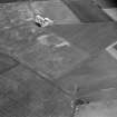
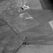
Aerial photography (RCAHMSAP 1976) has revealed the cropmarks of this ring-ditch on a gentle S-facing slope about 300m SSW of Lawfolds farmsteading (NJ62NE 169); it measures at least 25m in diameter within a ditch about 2m in breadth.
Information from RCAHMS (JRS), 17 February 1998.
Project (April 2006 - October 2006)
The proposed underground cable runs from N of Kirkton Farm, Colpy, AB52 6XD to Blackhall Road (adjacent to Westburn Gardens), Inverurie, AB51 5SN. The National Grid Reference of the NW end is NJ64961 33749 and the SE end is NJ75620 21721. The proposed cable is in Culsalmond Parish (NW end) and Inverurie (SE end). The height is 245-250m OD (NW end) and 95-100m (SE end). 1.2 The work was commissioned by Gordon McConachie, CKD Galbraith LLP for SSE. All the archaeological work will be carried out in the context of Scottish Planning Policy (SPP) Planning Advice Note (PAN 2/2011) and Scottish Historic Environment Scotland’s Policy Statement (HESPS), which state that archaeological remains should be regarded as part of the environment to be protected and managed.
Following a Desk-Based Assessment, a walkover of the entire length of the cable trench, carried out 30 April - 5 May 2016, revealed no new sites on the route but a number of Scheduled Monuments and archaeological and historical sites have been identified on the route and a watching brief was required in six areas. Six trenches were monitored between 14 June and 26 September 2016. At least two and possibly four prehistoric ring ditches with associated pottery were identified in two trenches and these were retained in situ and a clear path identified in each case for the cable trench. The base of a possible rock-cut ditch was uncovered at Durno and this was recorded, sampled and backfilled. At this area of the Roman camp the cropmark is not visible as the underlying geology is bedrock.
One ring ditch was found at the N end of the pipeline associated with prehistoric pottery and one definite and two potential ring ditches at Glenniston. In the road within Logie Durno Roman Camp, the base of a possible ditch was identified in an area where the cropmark is not visible as the underlying geology is bedrock. The watching briefs are now complete and the cabling being laid. A Post-Excavation Research Design (PERD) will now be prepared for the post-excavation works required.

