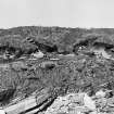
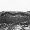
 |
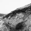
On-line Digital Images |
SC 1854342 |
Viking and Early Settlement Archaeology Research Project |
Photographic survey of cliff section: Cutting 6 area. |
1978 |
Item Level |
|
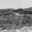 |
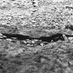
On-line Digital Images |
SC 1854343 |
Viking and Early Settlement Archaeology Research Project |
Photographic survey of cliff section: Cutting 5 before excavation. |
1978 |
Item Level |
|
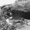 |
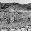
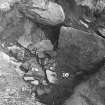
On-line Digital Images |
SC 1854358 |
Viking and Early Settlement Archaeology Research Project |
Photographic survey of cliff section: Detail of Cutting 6 |
1978 |
Item Level |
|
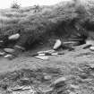 |
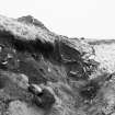
On-line Digital Images |
SC 1854359 |
Viking and Early Settlement Archaeology Research Project |
Photographic survey of cliff section: Detail of Cutting 6. |
1978 |
Item Level |
|
 |
On-line Digital Images |
SC 1854369 |
Viking and Early Settlement Archaeology Research Project |
Cutting 5: After the hurricane - erosion. |
1978 |
Item Level |
|
 |
On-line Digital Images |
SC 1854370 |
Viking and Early Settlement Archaeology Research Project |
Cutting 5: Trench looking west. |
1978 |
Item Level |
|
 |
On-line Digital Images |
SC 1854371 |
Viking and Early Settlement Archaeology Research Project |
Cutting 6: Section, photographed from beach. |
1978 |
Item Level |
|
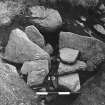 |
On-line Digital Images |
SC 1854372 |
Viking and Early Settlement Archaeology Research Project |
Cutting 5, showing Contexts 5 and 13. |
1978 |
Item Level |
|
 |
On-line Digital Images |
SC 1854373 |
Viking and Early Settlement Archaeology Research Project |
Cutting 5, showing Contexts 13 and 16. |
1978 |
Item Level |
|
 |
On-line Digital Images |
SC 1854374 |
Viking and Early Settlement Archaeology Research Project |
Cutting 5: Hurricane damage to cutting, looking east. |
1978 |
Item Level |
|
 |
On-line Digital Images |
SC 1854375 |
Viking and Early Settlement Archaeology Research Project |
Cutting 5: Hurricane damage to cutting, looking west. |
1978 |
Item Level |
|
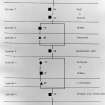 |
On-line Digital Images |
SC 1854377 |
Viking and Early Settlement Archaeology Research Project |
Cutting 6: Sequence diagram.
(NW most boat naust of HY22NW 45 was also uncovered) |
1978 |
Item Level |
|
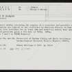 |
On-line Digital Images |
SC 2340018 |
Records of the Ordnance Survey, Southampton, Hampshire, England |
Point Of Buckquoy, HY22NW 22, Ordnance Survey index card, Recto |
1958 |
Item Level |
|
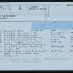 |
On-line Digital Images |
SC 2340019 |
Records of the Ordnance Survey, Southampton, Hampshire, England |
Point Of Buckquoy, HY22NW 22, Ordnance Survey index card, Recto |
1958 |
Item Level |
|
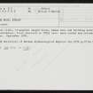 |
On-line Digital Images |
SC 2507502 |
Records of the Ordnance Survey, Southampton, Hampshire, England |
Point Of Buckquoy, HY22NW 32, Ordnance Survey index card, Recto |
1958 |
Item Level |
|


