
Balblair


Standing Stone (Prehistoric)
Site Name Balblair
Classification Standing Stone (Prehistoric)
Alternative Name(s) Upper Balblair
Canmore ID 18000
Site Number NJ60NE 2
NGR NJ 6987 0661
Datum OSGB36 - NGR
Permalink http://canmore.org.uk/site/18000


- Council Aberdeenshire
- Parish Midmar
- Former Region Grampian
- Former District Gordon
- Former County Aberdeenshire
NJ60NE 2 6987 0661
For surrounding rig, see NJ60NE 92.
(NJ 6988 0660) Stone Circle (NR) (Remains of)
OS 6" map, Aberdeenshire, 2nd ed., (1902)
Standing Stone (NR)
OS 6" map, (1959)
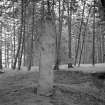
A single stone of reddish granite 8 1/2 feet (2.6m) in height. Its average width is about 18 inches (0.45m) but near the top it expands to 22 inches (0.56m). Its greatest thickness is 19 inches (0.48m) near the base narrowing to only 10 inches (0.25m) near the top.
The Ordnance Survey Name Book (ONB, 1864) says that this single stone, 'about 5 feet in height by 2 feet by 1 foot' is all that now remains of a 'temple'.
Browne (1921) mentions that the stone stands on a mound but he does not say if it is artificial, or a natural knoll.
J Ritchie 1919; F R Coles 1900; Name Book 1864; G F Browne 1921.
A standing-stone as described, on a small mound c.0.5 metres high, c.5.0 metres diameter, but whether this latter is contemporary is impossible to say.
Visited by OS (RL) 7 February 1968.
(Name cited as Upper Balblair).
NMRS, MS/712/55.
(NGR altered from NJ 6988 0660 to NJ 6987 0661). This standing stone is situated in a strip of woodland about 110m NNW of Midmar Church (NJ60NE 3). It is a pink granite pillar measuring 0.55m in breadth from NE to SW by 0.5m transversely at ground level and standing 2.6m in height.
Visited by RCAHMS (JRS), 16 April 1998.
Field Visit (15 July 1943)
This site was recorded as part of the RCAHMS Emergency Survey, undertaken by Angus Graham and Vere Gordon Childe during World War 2. The project archive has been catalogued during 2013-2014 and the material, which includes notebooks, manuscripts, typescripts, plans and photographs, is now available online.
Information from RCAHMS (GF Geddes) 4 December 2014.

