
Cairnmore


Fort (Period Unassigned)
Site Name Cairnmore
Classification Fort (Period Unassigned)
Alternative Name(s) Cairn More; Rhynie; Correen Hills
Canmore ID 17723
Site Number NJ52SW 9
NGR NJ 5035 2494
Datum OSGB36 - NGR
Permalink http://canmore.org.uk/site/17723


- Council Aberdeenshire
- Parish Auchindoir And Kearn
- Former Region Grampian
- Former District Gordon
- Former County Aberdeenshire
NJ52SW 9 5035 2494.
(NJ 5035 2494) Cairn More (NR).
OS 6" map, Aberdeenshire, 1st ed., (1866-70)
Fort (NR).
OS 6" map, (1959)
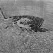
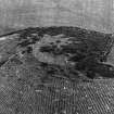
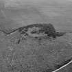
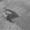
This stone fort occupies the termination of a broad spur protruding N from the Correen Hills to overlook the plain between Rhynie and Insch. It consists of an enclosure measuring 170 ft (51.8m) by 150 ft(45.7m) within two ruined walls, with an entrance in the SE. The gently-domed interior is featureless.
It is described in the ONB (1866) as large rough cairn of stones, undoubtedly an antiquity, no history or tradition of which exists. It adds that there was a proposal in 1866 to dig into it.
Name Book 1866; R W Feachem 1963.
Cairn More, a very ruined fort, as described by Feachem (1963).
Overlaid by an old field wall on the NE.
Re-surveyed at 1/2500.
Visited by OS (RL) 13 September 1967.
Visible on vertical air photographs: OS/67/237214-5.
(Undated) information in NMRS.
(Listed as 'Remains of a fort'). Air photograph: AAS/00/05/CT.
NMRS, MS/712/100.
This small fort lies at the end of a broad spur (Hare Hill) extending northwards from the foot of the N flank of the Correen Hills, and overlooks the abandoned farmsteading of Cairnmore. Oval on plan, it measures about 52m from NE to SW by 45m internally. An earlier survey of the fort (RCAHMS Marginal Lands Survey, 1956) recorded two concentric lines of defence. These are now largely invisible in dense gorse, but the N sector of the defences comprises a single broad spread of stones tumbled down the slope. This apparently encompasses both lines previously recorded, but on the evidence visible today are probably the remains of a single wall.
Visited by RCAHMS (JRS), 23 June 1999.
Field Visit (26 July 1943)
This site was recorded as part of the RCAHMS Emergency Survey, undertaken by Angus Graham and Vere Gordon Childe during World War 2. The project archive has been catalogued during 2013-2014 and the material, which includes notebooks, manuscripts, typescripts, plans and photographs, is now available online.
Information from RCAHMS (GF Geddes) 4 December 2014.
Field Visit (16 August 1956)
This site was included within the RCAHMS Marginal Land Survey (1950-1962), an unpublished rescue project. Site descriptions, organised by county, are available to view online - see the searchable PDF in 'Digital Items'. These vary from short notes, to lengthy and full descriptions. Contemporary plane-table surveys and inked drawings, where available, can be viewed online in most cases - see 'Digital Images'. The original typecripts, notebooks and drawings can also be viewed in the RCAHMS search room.
Information from RCAHMS (GFG) 19 July 2013.
Watching Brief (3 November 2009)
NJ 5037 2481 A watching brief was undertaken 3 November 2009 during construction works associated with a wind farm development to the S of Cairn More Fort (NJ52SW 9). No significant archaeological features or artefacts were encountered.
Archive: RCAHMS (intended)
Funder: Greenspan Energy
Victoria Clements and John Gooder – AOC Archaeology Group
Archaeological Evaluation (September 2010)
NJ 5035 2494 The RCAHMS volume of Strathdon identified six types of hillforts based on size and defensive systems. However, none of the sites has been dated. The Hillforts of Strathdon Project aims to recover dating evidence from one of each of the six classes of hillfort.
The fourth and final season of the project in September 2010 examined Cairnmore, a circular stone enclosure. All the features identified in the 10 trenches were excavated and recorded. The excavations indicated that the site is enclosed by three ramparts, the outer comprising a soil bank with a stone kerb, 1.3m wide and 0.2m high and an associated ditch, at least 0.5m wide and 0.22m deep. The ditch could not be traced beyond the SE
entrance, which at this point contained two possible wheel ruts c1m apart.
The second rampart, which had been previously identified by the RCAHMS, was recorded around the entire circuit of the hill and enclosed a sub-oval area of c64m by 44m. The entrance was at the SE, on a similar alignment to that in the outer rampart. The terminal was rounded and up to 4.5m wide by 0.5m high. A foundation cut associated with this terminal was linked with charcoal, burnt bone, two pin mould fragments and a crucible fragment. The rampart was of stone with a formal kerb and had been robbed in places to build internal platforms. Fragments of saddle quern rubbers were recorded in the content of this rampart.
An inner rampart, which survived up to 1.6m wide and 0.3m high (four courses), enclosed a smaller 50 x 40m area abutting the middle rampart. No entrance was located but it is likely to lie to the SE. The collapse from the inner rampart was associated with a substantial amount of charcoal and it seems possible that it had been destroyed by fire and then robbed to make internal platforms. A series of cobbled surfaces were recorded in the interior of the site.
Archive: RCAHMS (intended)
Funder: The Greenspan Agency, the authors
Murray Cook, Martin Cook and Jamie Humble – Rampart Scotland
Note (16 April 2015 - 25 October 2016)
The fort situated on the rounded summit of Cairn More, is almost entirely shrouded in gorse and whins, but a plan surveyed in 1956 for the RCAHMS Survey of Marginal Lands depicts the remains of two stone walls, the inner enclosing an area measuring about 52m from NE to SW by 46m transversely (0.19ha), and the outer about 64m by 44m (0.22ha). When revisited by RCAHMS investigators in 1999 this proved impossible to verify, and the walls on the N flank appeared as a single massive scree of tumbled stones, but an evaluation carried out in 2010 identified three lines of enclosure: an inner wall 1.6m in thickness; a substantial outer wall up to 4.5m in thickness by 0.5m in height; and an outer, stone-kerbed bank 1.3m in thickness by 0.2m in height with a shallow external ditch only 0.5m in breadth (Cook et al 2010); the entrance is on the SE. It is likely that the various perimeters represent several periods of construction, and one radiocarbon sample from a destruction deposit overlying the outer wall, and another from beneath the outer bank, returned dates about AD 410-630. Two early medieval brooch moulds and a pin mould were also recovered. Traces of cobbled surfaces were identified within the interior.
Information from An Atlas of Hillforts of Great Britain and Ireland – 25 October 2016. Atlas of Hillforts SC2956
Excavation (28 September 2018 - 1 October 2018)
NJ 5035 2494 A four day evaluation was carried out,
28 September – 1 October 2018, to further elucidate the form,
character and chronology of Cairnmore Fort – dated to the 5th
to 6th century AD by Murray Cook in 2011.
Seven trenches were laid out. Trenches 1, 2 and 3 targeted
the inner rampart exposing the core of the rampart, a putative
wall face and a charcoal spread. Trench 4 was located
directly W of Trench 5 but did not reveal any archaeological
features. Trench 5 was located in the SE area of the site, over
the inner rampart and possible entrance. A 6m stretch of the
rampart was revealed showing that the rampart survived to
3m wide with a tumble of stone extending eastwards on the
downslope side. A shallow pit or ditch terminal was also
uncovered. Trench 6 was laid out over the outer rampart
revealing an extensive spread of stones extending inwards
from the rampart edge. The core of the rampart could not
be clearly identified and there was a lack of definitive wall
facing. A shallow pit or truncated posthole was identified
lying outside of the rampart wall. Slag and a possible gaming
piece were recovered from the rampart core. Trench 7 was
located in the interior of the fort and revealed the remains of
a structure including a stone-built hearth and stone post-pad
as well as an extensive spread of large stones. The hearth
contained a least one fill.
There was no clear evidence of edges to the structure.
Another spread of large stones was located in the SW
corner of the trench but it could not be established if it was
associated with these internal features or a different structure
beyond the excavated area. A large spread of small stones
exposed in various sondages was interpreted as a putative
occupational surface and may be key to establishing the
layout to the internal structure. A flint blade and a gaming
piece were recovered from Trench 7.
Radiocarbon dating will clarify the chronology of the
rampart and the internal structure.
Archive: University of Aberdeen
Funder: University of Aberdeen and Leverhulme Trust
Gordon Noble, Edouard Masson-MacLean and Jeff Oliver –
University of Aberdeen
(Source: DES, Volume 19)
Excavation (11 August 2019 - 27 August 2019)
NJ 5035 2494 another season of excavation at Cairnmore fort (Canmore ID: 17723) occurred to further elucidate the character and chronology of a ringfort overlooking the Rhynie valley. In 2018, a trench in the interior of the fort had revealed the remains of a structure including a stone-built hearth and stone post-pad as well as an extensive spread of large stones.
Further work was carried out, 11-27 August 2019, to try and find the edges of the structure and further structural elements such as postholes. A trench was also excavated on the northern side of the fort that revealed a post-setting on the edge of the inner stone bank. The postholes in this setting were large (some over 1m in diameter) and were spaced around 2-3m apart. They appear to have formed a revetment to the bank. Each contained substantial quantities of charcoal and burnt bone and each was sampled for dating. Thirteen posts in total were identified, with eleven excavated and half-sectioned.
Archive: University of Aberdeen
Funder: University of Aberdeen
Gordon Noble; James O’Driscoll; Edouard Masson-MacLean - University of Aberdeen
(Source DES Vol 20)

