
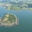
Ardwall Isle


Farmstead (Period Unassigned)
Site Name Ardwall Isle
Classification Farmstead (Period Unassigned)
Canmore ID 177045
Site Number NX54NE 19
NGR NX 5715 4918
Datum OSGB36 - NGR
Permalink http://canmore.org.uk/site/177045


- Council Dumfries And Galloway
- Parish Borgue
- Former Region Dumfries And Galloway
- Former District Stewartry
- Former County Kirkcudbrightshire
Note
A farmstead, comprising one roofed building, two unroofed buildings, one of which is annotated 'Ruin', one enclosure and a length of wall is depicted on the 1st edition of the OS 6-inch map (Kirkcudbrightshire 1854, sheet 49). One roofed building and three enclosures are shown on the current edition of the OS 1:10000 map (1982).
Information from RCAHMS (AKK) 27 June 2000.

