
Hoy, Lyness, Royal Naval Oil Terminal, Military Camp


Military Camp (First World War)
Site Name Hoy, Lyness, Royal Naval Oil Terminal, Military Camp
Classification Military Camp (First World War)
Alternative Name(s) Burnhouse; Scapa Flow
Canmore ID 174032
Site Number ND29NE 8
NGR ND 2982 9514
NGR Description Centred ND 2982 9514
Datum OSGB36 - NGR
Permalink http://canmore.org.uk/site/174032


- Council Orkney Islands
- Parish Walls And Flotta
- Former Region Orkney Islands Area
- Former District Orkney
- Former County Orkney
ND29NW 8 centred 2982 9514
See also ND39SW 20.00, ND29SE 5 and ND39NW 170
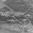
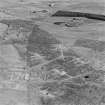
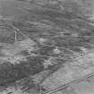
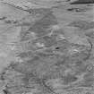
The remains of a military camp visible as concrete hut bases and roadways are situated on the W side of the B9047 road about 400m SW of Burnhouse. The bases and platforms for over fifty huts or buildings of diffrent sizes all linked to a road system, can be seen in rough boggy ground to the S of the Burn of Moifea.
The camp is not shown on the facsimile Plan of Lyness, Civil Engineers Department of the Admiralty, 1941 available at the Scapa Museum, Lyness.
The outline of this camp is shown on the OS 1:2500 scale digital map of this area.
Visited by RCAHMS, (DE), August 1999
Project (March 2013 - September 2013)
A project to characterise the quantity and quality of the Scottish resource of known surviving remains of the First World War. Carried out in partnership between Historic Scotland and RCAHMS.

