
Craig Dorney


Fort (Period Unassigned)
Site Name Craig Dorney
Classification Fort (Period Unassigned)
Canmore ID 17275
Site Number NJ43NW 20
NGR NJ 404 353
Datum OSGB36 - NGR
Permalink http://canmore.org.uk/site/17275


- Council Aberdeenshire
- Parish Glass
- Former Region Grampian
- Former District Gordon
- Former County Aberdeenshire
NJ43NW 20 404 353
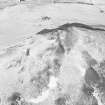
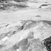
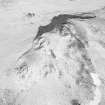
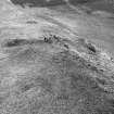
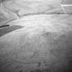
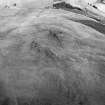
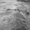
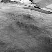
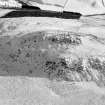
Surrounding the craggy summit of Craig Dorney, terracing and ditching indicate a hill-fort of maximum dimensions approximately 90m NE-SW by 45m.
I Ralston 1988.
(Location cited as NJ 405 353). Craig Dorney. Air photography has recorded a fort in an area of rough grazing and former woodland on a prominent rocky summit at an altitude of 400m OD. The fort is well preserved but there is mole disturbance within the interior.
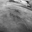
A terrace encloses the summit, which is flanked at the E end (where access is easiest) by a second similar (but slightly smaller) feature. A further ditch (with a scarp slope on its inner margin) occurs about 30m downslope from the principal circuit. Within the SW quadrant of the fort, various traces of straight lengths of drystone walling (some of them little more than rickles) are apparent, but these are not necessarily contemporary with the enveloping work.
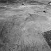
Outside the fort to the SE (and in an area of former woodland) there are possible traces of platforms. There is a modern cairn within the interior.
[Air photographic imagery listed].
NMRS, MS/712/36, visited by AAS (IBM and S Ralston), 29 March 1989.
Note (9 April 2015 - 18 May 2016)
The remains of a fort enclose the rocky summit of Craig Dorney, Oval on plan, the remains of a rampart reduced to a terrace can be traced round the margin of the summit, probably enclosing an area measuring about 70m from NE to SW by 38m transversely (0.25ha). On the NE, where the access is easiest, there is a second line forming a slighter terrace, while further down the slope a ditch can be seen extending round the NE, SE and SW flanks; the latter encloses an area measuring about 90m from NE to SW by 48m transversely (0.38ha). The interior is largely featureless, though traces of drystone walls have been noted at the SW end. The position of the entrance is not known.
Information from An Atlas of Hillforts of Great Britain and Ireland – 18 May 2016. Atlas of Hillforts SC2943

