
The Lang Stane


Natural Feature (Period Unknown), Standing Stone (Prehistoric)
Site Name The Lang Stane
Classification Natural Feature (Period Unknown), Standing Stone (Prehistoric)
Alternative Name(s) Easter Sinnahard; The Lang Stone
Canmore ID 17139
Site Number NJ41SE 9
NGR NJ 4803 1394
Datum OSGB36 - NGR
Permalink http://canmore.org.uk/site/17139


- Council Aberdeenshire
- Parish Towie
- Former Region Grampian
- Former District Gordon
- Former County Aberdeenshire
NJ41SE 9 4803 1394.
(NJ 4803 1394) Standing Stone (NR)
OS 6" map, Aberdeenshire, 2nd ed., (1902)
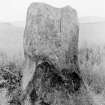
A large block of whinstone, believed locally to mark the site of a battle. It is known as 'The Lang Stone' and is 5' 6" (1.68m) high, 2' 6" (0.76m) broad and 8' 6" (2.59m) in circumference. There is one single cup-mark in the centre of the western side.
Name Book 1866; J Ritchie 1918.
The Lang Stane, a standing stone as described.
Revised at 1/2500.
Visited by OS (R L) 4 September 1968.
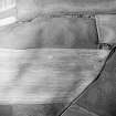
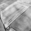
(Classification amended to Standing Stone; 'Cup-marking': Nil Antiquity). This granite standing stone is situated on a cultivated river terrace on the right bank of the River Don 340m NW of Easter Sinnahard farmsteading (NJ41SE 93). It measures 1.2m in breadth by 0.55m in thickness at ground level and 1.85m in height. What appears to be a cupmark halfway up the NNW face of the stone is probably of natural origin; it is 70mm in maximum diameter.
Visited by RCAHMS (JRS, KM), 2 October 1997.

