|
Photographs and Off-line Digital Images |
O 2610 |
Papers of Dr Raymond G Lamb, archaeologist, Keith, Moray, Scotland |
R.Lamb |
1970 |
Item Level |
|
|
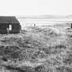
Photographs and Off-line Digital Images |
O 3443 |
John Dewar |
Oblique aerial photograph |
7/1965 |
Item Level |
|
|
Photographs and Off-line Digital Images |
O 3444 |
John Dewar |
Oblique aerial photograph
|
7/1965 |
Item Level |
|
|
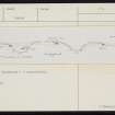
Prints and Drawings |
ORD 62/1 |
Records of the Royal Commission on the Ancient and Historical Monuments of Scotland (RCAHMS), Edinbu |
Publication drawing; plan of fortified promontory, Point of Onston |
1928 |
Item Level |
|
|
Prints and Drawings |
ORD 62/2 |
Records of the Royal Commission on the Ancient and Historical Monuments of Scotland (RCAHMS), Edinbu |
Plane-table survey |
1928 |
Item Level |
|
|
Prints and Drawings |
ORD 62/3 |
Papers of Dr Raymond G Lamb, archaeologist, Keith, Moray, Scotland |
Plan BAR fig20 Ink Lamb after Calder |
|
Item Level |
|
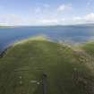 |
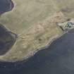
On-line Digital Images |
DP 214540 |
Papers of Dr George F Geddes, archaeologist, Edinburgh, Scotland |
Oblique aerial view of Point of Onston fort, looking N. |
5/2015 |
Item Level |
|
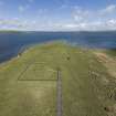 |
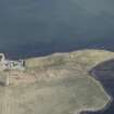
On-line Digital Images |
DP 214541 |
Papers of Dr George F Geddes, archaeologist, Edinburgh, Scotland |
Oblique aerial view of Point of Onston fort, looking N. |
5/2015 |
Item Level |
|
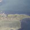 |
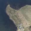
On-line Digital Images |
DP 273417 |
Historic Environment Scotland |
Oblique aerial view. |
24/3/2018 |
Item Level |
|
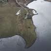 |
On-line Digital Images |
DP 273420 |
Historic Environment Scotland |
Oblique aerial view. |
24/3/2018 |
Item Level |
|
 |
On-line Digital Images |
DP 273423 |
Historic Environment Scotland |
Oblique aerial view. |
24/3/2018 |
Item Level |
|
 |
On-line Digital Images |
DP 273425 |
Historic Environment Scotland |
Oblique aerial view. |
24/3/2018 |
Item Level |
|
 |
On-line Digital Images |
DP 273428 |
Historic Environment Scotland |
Oblique aerial view. |
24/3/2018 |
Item Level |
|
 |
On-line Digital Images |
SC 1923381 |
Papers of Dr Raymond G Lamb, archaeologist, Keith, Moray, Scotland |
R.Lamb |
1970 |
Item Level |
|
 |
On-line Digital Images |
SC 2339739 |
Records of the Ordnance Survey, Southampton, Hampshire, England |
Point Of Onston, HY21SE 22, Ordnance Survey index card, page number 1, Recto |
1958 |
Item Level |
|
 |
On-line Digital Images |
SC 2339740 |
Records of the Ordnance Survey, Southampton, Hampshire, England |
Point Of Onston, HY21SE 22, Ordnance Survey index card, page number 2, Verso |
1958 |
Item Level |
|
 |
On-line Digital Images |
SC 2339741 |
Records of the Ordnance Survey, Southampton, Hampshire, England |
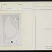
Point Of Onston, HY21SE 22, Ordnance Survey index card, Recto |
1958 |
Item Level |
|
 |
On-line Digital Images |
SC 2339742 |
Records of the Ordnance Survey, Southampton, Hampshire, England |
Point Of Onston, HY21SE 22, Ordnance Survey index card, Recto |
1958 |
Item Level |
|
 |
On-line Digital Images |
SC 2339743 |
Records of the Ordnance Survey, Southampton, Hampshire, England |
Point Of Onston, HY21SE 22, Ordnance Survey index card, page number 2, Recto |
1958 |
Item Level |
|
 |
On-line Digital Images |
SC 2339744 |
Records of the Ordnance Survey, Southampton, Hampshire, England |
Point Of Onston, HY21SE 22, Ordnance Survey index card, page number 1, Recto |
1958 |
Item Level |
|
|
All Other |
551 166/1/1 |
Records of the Ordnance Survey, Southampton, Hampshire, England |
Archaeological site card index ('495' cards) |
1947 |
Sub-Group Level |
|


