
Point Of Onston


Promontory Fort (Period Unassigned)
Site Name Point Of Onston
Classification Promontory Fort (Period Unassigned)
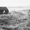
Alternative Name(s) Diamond Cottage
Canmore ID 1710
Site Number HY21SE 22
NGR HY 28284 11791
Datum OSGB36 - NGR
Permalink http://canmore.org.uk/site/1710


- Council Orkney Islands
- Parish Stenness
- Former Region Orkney Islands Area
- Former District Orkney
- Former County Orkney
HY21SE 22 2821 1176.
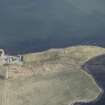
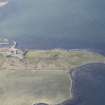
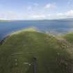
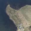
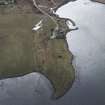
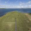
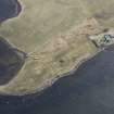
(HY 282 117) The promontory known as 'Point of Onston' has been cut off on the south side by two carefully constructed lines of rampart and ditch. The ramparts are now only 2 to 3ft high and have, seemingly, been formed of the upcast from the ditches, of which the outer is 19ft and the inner 16 ft wide from crest to crest. There are slight gaps in the lines, any one of which may mark an entrance.
RCAHMS 1946, visited August 1928.
This earthwork may well be an example of 'Scandinavian ness-taking.' The stones of a former revetment continue out into the loch at the north end of the earthwork.
Information from Orkney survey 1960, Wainwright notes, plan.
A promontory earthwork as described by the RCAHMS. The ramparts and ditches are best defined on its east side, and have been destroyed at the centre by cultivation. On the west side, only vague traces remain in the form of three 'rises' in the ground which have been greatly spread by cultivation. Centred at HY 2830 1175.
The entrance was at the NE corner and is marked by a causeway.
Surveyed at 1/2500.
Visited by OS (RB) 10 May 1966.
Scheduled as Diamond Cottage, defended promontory.
Information from Historic Scotland, scheduling docum,ent dated 10 January 1994.
Project (May 2007)
HY 285 140 The programme of geophysical investigations in and around the ‘Heart of Neolithic Orkney’ began in 2002 and to date approximately 240ha have been surveyed including this year’s season (Phases X) which started in May 2007 and is still ongoing. Gradiometry and resistance survey at the Point of Onston around the chambered tomb and within the fortified promontory have revealed a number of anomalies of archaeological interest although the data suggest that few remains exist beyond the visible earthworks. Resistance survey over Big Howe Broch has confirmed the ‘lightbulb’ shaped enclosure ditch suggested by previous gradiometer survey and has detected part of the tower which is approximately 30m in diameter. There is some suggestion of additional stone structures. Elsewhere gradiometer survey has detected numerous responses indicative of ridge and furrow cultivation. Some discrete areas of enhanced response have also been located which may be of archaeological interest.
Archive deposited with the Geophysics Unit, Orkney College.
Funder: Historic Scotland, Orkney Islands Council, Orkney Archaeological Trust, Orkney College Geophysics Unit.
Magnetometry (May 2007)
HY 285 140 A programme of magnetometry in and around the ‘Heart of Neolithic Orkney’ began in 2002 and to date approximately 240ha have been surveyed including this year’s season (Phases X) which started in May 2007 and is still ongoing.
Archive deposited with the Geophysics Unit, Orkney College.
Funder: Historic Scotland, Orkney Islands Council, Orkney Archaeological Trust, Orkney College Geophysics Unit.
Resistivity (May 2007)
HY 285 140 A programme of resistivity in and around the ‘Heart of Neolithic Orkney’ began in 2002 and to date approximately 240ha have been surveyed including this year’s season (Phases X) which started in May 2007 and is still ongoing.
Archive deposited with the Geophysics Unit, Orkney College.
Funder: Historic Scotland, Orkney Islands Council, Orkney Archaeological Trust, Orkney College Geophysics Unit.
Note (23 February 2015 - 18 May 2016)
An earthwork comprising twin concentric ditches and banks is drawn in a regular arc across the low-lying tip of Onston Point. The ditches are both about 3m broad, lying to either side of a low medial bank about 0.6m high, and the second low bank stands on the counterscarp of the outer ditch. There are several gaps along its line, but aerial photographs suggest a slight misalignment to either side of one 40m E of the W shore, perhaps indicating this is original, though the OS surveyor in 1966 suggested there was an entrance causeway near the NE shore. The roughly triangular interior is featureless and measures 130m from N to S, tapering from a maximum 80m transversely immediately to the rear of the earthwork to a point in the shallows of the loch (0.66ha). At the NE end of the perimeter, however, aerial photographs also show traces of a line of stones extending N in a straight line for a distance of at least 60m beneath the water, possibly indicating that the enclosed area on dryland was once considerably larger. The date and purpose of this promontory work are unknown.
Information from An Atlas of Hillforts of Great Britain and Ireland – 18 May 2016. Atlas of Hillforts SC2838

