
Knockargety Hill


Fort (Period Unassigned)
Site Name Knockargety Hill
Classification Fort (Period Unassigned)
Alternative Name(s) Knock Hill; Knockargetty Hill; Knockargety Wood; Upper Ruthven
Canmore ID 17028
Site Number NJ40SE 3
NGR NJ 4540 0307
Datum OSGB36 - NGR
Permalink http://canmore.org.uk/site/17028


- Council Aberdeenshire
- Parish Logie-coldstone
- Former Region Grampian
- Former District Kincardine And Deeside
- Former County Aberdeenshire
NJ40SE 3 454 030.
(NJ 454 030) Remains of supposed Camp (NR)
OS 6" map, Aberdeenshire, 2nd ed., (1902)
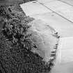
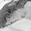
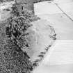
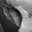
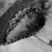
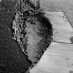
This unfinished fort lies on a ridge in open woodland which overlooks the Muir of Dinnet from the N. It is oval, measuring about 800ft (243m) by 390ft (119m) within a single line marked out partly by a slight terrace and partly by an equally slight trench. Work was begun on piling up a rampart on either side of the entrance in the E and W, but had not gone very far before the project was abandoned.
R W Feachem 1963.
Fort as described by Feacham.
Revised at 1/2500.
Visited by OS (R L) 29 October 1968.
Fort [NR] (unfinished) [NAT]
OS 1:10,000 map, 1972.
'Ploughed, replanted, slopes reduced'
Information from OS, May 1986.
This fort is of comparable character to that at Dunnideer (NJ62NW 1). The earthworks are clearest on the E and around almost the whole of the NM circuit; there is a track over the W side and the circuit is much less easily-traced around the (steeper) S side. Conifers have been planted over the N circuit, but the S circuit has been cleared.
(GRC/AAS air photographs listed).
Information from Aberdeenshire Archaeological Service, June 1997 (visited 3 September 1990).
NMRS, MS/712/19.
This fort is situated on the crown of a low but still steep-sided and prominent hill, at an altitude of 260m OD. The vegetation is a mixture of grass, heather and woodland.
NMRS, MS/712/36.
Field Visit (17 July 1957)
Fort, Knockargety Hill.
This fort is situated at a height of 850 feet OD 400 yards north of Upper Ruthven farmhouse on the broad rounded summit of an isolated hill. At the date of visit the hill was included in the conifer plantation of Knockargety Wood and although it was comparitively clear of scrub the surface of the ground was clothed with long grass, blueberry bushes and patches of heather. The fort is a regular oval on plan measuring about 800 feet from east to west by about 390 feet transversely; it is defined by a line which consists in part of a ditch and in part of s scarp. The east and west arcs, which run across the summit ridge, appear as ditches up to one foot in depth at the west and 3 feet at the east. Causeways 15 feet in width cross both these stretches of ditch, and for a short distance on either side of them stretches of low stone banks run along the inner lips of the ditches. As the defences are followed south from the entrances the banks soon die out and the ditches fade more gradually until the whole of the central portion of the south stretch is formed only by a scarp, a continuation of te inner scarp of the ditch with a terrace at its foot. Likewise, the north stretch of the ditch is formed partly by short stretches of ditch and partly by lengths of scarp; at several places fragmentary low mounds are visible on the outside of the excavations forming the north sector.
The degree of slope of the north and south flanks of the hill are not enough to support the suggestion that a once complete inner mound could have rolled away down them and left so few traces; nor are they so steep as to disallow the digging of a ditch and the construction of a rampart along their contours. The state of the remains is explained, therefore, as representing an incomplete state of work. The ditch and scarp, the former mostly very shallow, may thus represent an early stage in the construction of a quarry from which material for a rampart could be obtained. As both became deeper so the rampart would grow, but only at a point north of the east entrance is any part of the ditch as yet as deep as 3 feet. As has been noted elsewhere (of Dunideer [NJ62NW 1]) work appears to have started on a second phase of construction in the vicinity of the entrances. No sign of other defensive lines could be seen, but it is possible that a marker trench might exist among the trees and coarse pasture either within or outside the existing remains. No support could be found for Ogston’s suggestion that boulders inside the defences formed an inner ring (1931, 102).
Visited by RCAHMS (RWF) 17 July 1957.
Note (6 April 2015 - 18 May 2016)
This fort is situated on the summit of a domed ridge on the edge of what was formerly Knockargety Wood. Roughly oval on plan, it measures about 240m from ENE to WSW by 115m transversely (2.12ha), within a shallow ditch that has been interpreted as little more than a marker trench for an unfinished circuit (Feachem 1963, 104). The ditch is up to 0.9m deep where it crosses the spine of the ridge on the ENE, but elsewhere it is reduced to a slight scarp extending along the flanks of the hill, and on the SSE disappears altogether; the only trace of an accompanying bank or rampart is at either end. There are entrances gaps 4.5m wide on both the ENE and the WSW, and the internal bank is evidently thickest and highest to either side of the eastern. The interior is featureless. While interpreted as unfinished, the expansion of the bank to either side of the entrance is a pattern that can be seen also at Dunnideer, and perhaps indicates that, rather than being unfinished, the form of the enclosure is much as the builders intended it.
Information from An Atlas of Hillforts of Great Britain and Ireland – 18 May 2016. Atlas of Hillforts SC2937

