
Bellie


Temporary Camp (Roman)
Site Name Bellie
Classification Temporary Camp (Roman)
Canmore ID 16947
Site Number NJ36SE 8
NGR NJ 355 611
Datum OSGB36 - NGR
Permalink http://canmore.org.uk/site/16947


- Council Moray
- Parish Bellie
- Former Region Grampian
- Former District Moray
- Former County Morayshire
NJ36SE 8 355 611
See also NJ36SE 20.
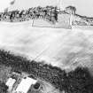
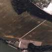
(Area: NJ 355 613) A probable Roman, V-shaped ditch, extending 975' on a straight N-S alignment was excavated in 1967. It was 7' wide and 3' deep where best preserved, had been cut in loose gravel and the east side was consistently steeper than the west. The filling showed that the ditch had lain open until silt and earth accummulated to the angle of rest. The silt was overlaid by 2' of plough-soil, presumbably post 18th century. Since bottle fragments dated to between 1770 and 1780 lay between the separate layers. No gate was found. The ditch is well-sited to from the east side of a defended enclosure, centred on the area NJ 355 613, and and possibly as large as 900' by 1200' if allowance is made for river erosion. It would be protected on the west by the Spey and on the east by a marshy hollow formerly a morass. Position and profile of ditch suggest strongly that the site is Roman, in which case it would be 'a Flavian camp, either Stracathro-type or '30 acre'.
J K St Joseph 1969.
No surface indication of this camp. According to Keiller (I Keillar, secretary Elgin Soc) who saw the area some time after the excavation the ditch runs S from NJ 3555 6113. Three of St. Joseph's excavation trenches across it were still open at the time of his visit, but have since been filled in and the area ploughed and cultivated.
Visited by OS (A A) 19 May 1971.
(Location cited as NJ 3550 6130 and cited as Site of Regional Significance). Roman camp, with V-shaped ditch cut into loose gravel, the E side being steeper than the W. Trench excavation showed that the ditch had lain open until c. 1770 as bottle fragments lay between silt layer and 0.61m depth of ploughsoil. No gateway found. Possibly Flavian: either Stracathro-type or 30-acre. [Air photographic imagery listed].
NMRS, MS/712/35.
Trial Trench (1967)
Excavation trenches across the enclosure ditch of a Roman Temporary Camp at Bellie by J K St Joseph. Manuscripts from the Barri Jones collection.
(Area: NJ 355 613) A probable Roman, V-shaped ditch, extending 975' on a straight N-S alignment was excavated in 1967. It was 7' wide and 3' deep where best preserved, had been cut in loose gravel and the east side was consistently steeper than the west. The filling showed that the ditch had lain open until silt and earth accummulated to the angle of rest. The silt was overlaid by 2' of plough-soil, presumbably post 18th century. Since bottle fragments dated to between 1770 and 1780 lay between the separate layers. No gate was found. The ditch is well-sited to from the east side of a defended enclosure, centred on the area NJ 355 613, and and possibly as large as 900' by 1200' if allowance is made for river erosion. It would be protected on the west by the Spey and on the east by a marshy hollow formerly a morass. Position and profile of ditch suggest strongly that the site is Roman, in which case it would be 'a Flavian camp, either Stracathro-type or '30 acre'.
J K St Joseph 1969.
Publication Account (17 December 2011)
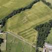
The probable camp at Bellie was first recorded by Macfarlane in his Geographical Collections (1726, in Mitchell 1906) and also in Chalmers Caledonia, based on information from Colonel Imrie in 1799 (1807: i, 129). On a visit to the area, Crawford reported that nothing was visible on the ground, and, while he voiced some doubts about the site as a Roman camp, he recorded that the site had been observed from the air in May 1943 by Mr R F Jessup. Crawford then placed the camp centred at about NJ 3573 6170, just over 100m south-west of where the ‘fosse’ of the camp had been placed by the Ordnance Survey (1st edition: Banffshire 1872: sheet i) (Crawford 1949: 122–5, fig 321; see illus 214). The area was subject to excavations by St Joseph in 1967, who confirmed a probable Roman camp with a centre at about NJ 355 613 (1969: 113), some 400m south of where the camp had been placed by Crawford. Fragments of a glass bottle from about 1770–80 were found in the top of the ditch (but below the plough soil), suggesting that it had lain open until the later part of the 18th century, which broadly fitted in with the antiquarian accounts. Keillar reported to the Ordnance Survey archaeology branch that the ditch St Joseph excavated ran south from NJ 3555 6113 (this grid reference is located just in Lion’s Den Wood) and that three of St Joseph’s trenches across it were still open at the time of his visit (OS Recorder 1971). However, the illustrations in the St Joseph Collection in the RCAHMS (DC 37252; Notebook 4) indicate that the ditch he excavated was farther north, and ran north-east to south-west from NJ 3569 6134 to NJ 3548 6112. The two trenches that he illustrates (RCAHMS DC 37253; St Joseph Collection: Notebook 4) do not demonstrate a particularly V-shaped profile, although he recorded that the ditch was about 2.1m in width and over 0.9m in depth (St Joseph 1969: 113). In 1984, Jones and Keillar recorded the well-rounded northern corner of a camp at NJ 355 611, together with a long linear cropmark running in the same field (1984: 12). The note that appeared in the ‘Roman Britain in 1985’ section of Britannia recorded this slightly to the north at NJ 355 612 (Frere 1986: 370). It is presumably the cropmark of this possible camp recorded by Jones and Keillar that was subject to further excavations by Daniels in 1986, who intersected the ditch in five places. The only published report of these excavations indicates that the location of the camp was at NJ 354 610 and that the ditch was shallow and about 2m wide (Keillar 1987: 11). In addition, the summary in Britannia noted that the ditch traced by St Joseph in 1967 probably related to an 18thcentury
road (Frere 1986: 370). It is worth noting that St Joseph did question the absolute Roman date of the site in his summary article (St Joseph 1969: 113).
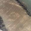
The area lies to the north of Fochabers, just north of the old Church of Bellie, on the east side of the River Spey only 4km from the Moray coast. The area is now under arable cultivation, and it lies on a fairly flat terrace, which slopes gently up to Whiteash Hill to the south-east. Immediately to the north is an area known as Roman Camp Wood and Romancamp Gate. The old Statistical Account notes that the camp in Bellie parish is traditionally known as the Danish camp, possibly connected with a battle between the Scots and the Danes (Sinclair 1795a: xiv, 271).
The air photographs taken by Jones were not available, but a study of photographs taken by Cambridge University in the 1970s–80s and Aberdeenshire Archaeology Service (AAS ) in 1982 reveals a linear cropmark to the east of Bellie Church, running south-west to north-east for about 160m and turning in a rounded angle to the southeast, before running into the Lion’s Den plantation. This provisionally has the characteristics of a Roman camp. It lies at about NJ 3551 6103 and is possibly the same feature as that recorded by Jones and Keillar. It is also close to where Keillar noted St Joseph’s trenches lay, although the drawings in the RCAHMS demonstrate that this was incorrect, and, indeed, St Joseph’s article suggested that he was expecting the cropmark that he excavated to represent part of the east side of an enclosure, not the north-west side of an enclosure, close to the north corner (1969:
113). The linear cropmark that St Joseph excavated is also clearly visible on the air photographs, but demonstrates no obvious Roman characteristics, and his section drawings do not present unequivocal evidence for a Roman origin. Therefore, Jones’ suggestion that the cropmark excavated by St Joseph represents the remains of an 18th-century road
seems more likely (Frere 1986: 370). Certainly a Roman date cannot be comfortably given to this feature. The lack of information on Daniels’ excavations does not assist in
the interpretation of that feature as a camp, although this may be the same feature visible on the Cambridge and AAS air photographs noted above. The discovery of an interior pavement of flat sandstones in the interior of the camp during Daniels’ excavations raises questions about the temporary camp classification of the feature excavated (Keillar 1987: 11).
The level of confusion surrounding this site suggests that it should be regarded as a probable camp, rather than given the accolade of (currently) the most northerly camp known in the Roman Empire. Leslie notes the possibility that there may be two separate sites here (1995: 317), and there do seem to be two distinct locations, firstly where Crawford and the OS recorded the camp, and secondly the site visible on air photographs (which may have been that excavated by Daniels). Whether any or all of these features are Roman in date awaits further investigation
R H Jones.

