
Verron


Broch (Iron Age)(Possible), Midden (Period Unassigned)
Site Name Verron
Classification Broch (Iron Age)(Possible), Midden (Period Unassigned)
Alternative Name(s) Knowe Of Verron; Bay Of Skaill
Canmore ID 1675
Site Number HY21NW 22
NGR HY 2305 1976
Datum OSGB36 - NGR
Permalink http://canmore.org.uk/site/1675


- Council Orkney Islands
- Parish Sandwick
- Former Region Orkney Islands Area
- Former District Orkney
- Former County Orkney
HY21NW 22 2305 1976.
(HY 2305 1975) Brough {NR} (Site of)
O.S.6"map, Orkney, 2nd ed.,(1903).
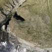
Knowe of Verron: The site of a prehistoric building, probably a broch. All that remains is a mound which has been dug into on the top and is now much broken up and covered with a heavy growth of turf and long grass.
It measures about 66ft from north to south by 75ft from east to west, and 5ft 3 ins high. No characteristic masonry is exposed and no detailed measurements were possible.
Underneath the south side of the mound is a kitchen-midden deposit of cockle-shells and other food refuse, from which a large quantity of coarse broch-type pottery was re-covered by the Commission investigator.
RCAHMS 1946.
As described by the Commission. Nodules of melted iron ore were found in the midden by the OS field walker(AA).
Resurveyed at 1/2500.
Visited by OS(AA) 20 May 1967.
RCAHMS call this the 'Knowe of Verron' but this could not be verified locally.
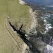
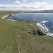
HY 2305 1975 A programme of rescue work was carried out in September 2001 on an actively eroding Scheduled Ancient Monument (NMRS HY21NW 22), on a low headland on the N side of the Bay of Skaill. Deposits including structural remains and metalworking deposits had been previously noted. A large stone covered with vitrified matter, then visible, was thought to represent a possible furnace base. This artefact had been removed from the site by a member of the public prior to the commencement of work and has not yet been retrieved.
Work on the site consisted of limited excavation and section recording, which indicated that two structures are present in the coastal exposure. The earliest structure appears to be sub-rectangular or oval in plan. It has a flagged floor, internal fittings and a large hearth. The later building is more poorly preserved but retains remnants of a paved floor and a probable flue. Deposits within this building contained quantities of peat ash and metalworking debris.
Sponsors: Historic Scotland, Orkney Archaeological Trust.
H Moore and G Wilson 2001
Publication Account (2002)
HY21 12 VERRON 2 ('Knowe of Verron')
HY/231198
Possible broch on the shore in Sandwick, on the south point of Verron Geo. There is nothing now but much quarried mound which looks as though it covers the ruins of a stone building. A midden is close to the south side and has produced potsherds and food refuse.
In 2001 a small rescue excavation was carried out at the eroding site and found metalworking debris and traces of structures [3].
Sources: 1. HY 21 NW 22: 2. RCAHMS 1946, 2, no. 682, 254. 3. Discovery and Excavation 2001, 71-2.
E W MacKie 2002

