
Park Hill


Archaeological Landscape (Medieval) - (Post Medieval)
Site Name Park Hill
Classification Archaeological Landscape (Medieval) - (Post Medieval)
Canmore ID 166110
Site Number NY48NE 189
NGR NY 4710 8705
NGR Description Centred on NY 4710 8705
Datum OSGB36 - NGR
Permalink http://canmore.org.uk/site/166110


- Council Scottish Borders, The
- Parish Castleton
- Former Region Borders
- Former District Roxburgh
- Former County Roxburghshire
Field Visit (3 April 1996 - 18 April 1996)
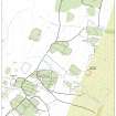
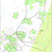
NY48NE 189.00 centred on 4710 8705
189.01 NY 4662 8639 Boundary banks; Rig
189.02 NY 4732 8772 Farmstead (LID96 354-5, 369)
189.03 NY 4736 8790 Building, Boundary bank (LID96 382)
189.04 NY 4783 8774 Buildings; Field-banks (LID96 366-7)
189.05 NY 4768 8765 Buildings (LID96 356-7)
189.06 NY 4698 8759 Hut, Enclosure (LID96 353)
The greater part of the E flank of Park Hill is enclosed by three ditched boundary banks, which displays three distinct phases of construction (NY48NE 189.01). The earliest and largest enclosure extends as far as Kirk Hill to the SSW. The two subsequent phases of enclosure are smaller, but in each case the earlier boundaries that lay outside them may have been maintained. Four groups of buildings, probably farmsteads, occupy terraces within the enclosures and comprise between one and three buildings (NY48NE 189.02, 03, 04, 05). A hut and enclosure lie immediately outside the enclosed ground near the summit of Park Hill. Rig, mostly measuring about 4m to 5m between furrows, can be seen in places across the hill, but has generally been levelled by landscaping for Newcastleton golf course.
Visited by RCAHMS (DCC) 3 and 18 April 1996

