
Logierait


Enclosure (Period Unassigned)(Possible)
Site Name Logierait
Classification Enclosure (Period Unassigned)(Possible)
Canmore ID 165637
Site Number NN95SE 74
NGR NN 97431 52067
Datum OSGB36 - NGR
Permalink http://canmore.org.uk/site/165637


- Council Perth And Kinross
- Parish Logierait
- Former Region Tayside
- Former District Perth And Kinross
- Former County Perthshire
NN95SE 74 NEW
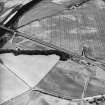
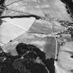
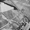
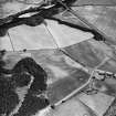
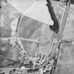
Aerial photographs have revealed the cropmark of the SW corner of a possible rectilinear enclosure in a field immediately S of Ferry Cottage, Logierait. The visible traces suggest an enclosure measuring 60m by 30m.
Information from JAM 1996
Aerial Photographic Transcription (1 May 2012)

