 |
On-line Digital Images |
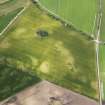
DP 093639 |
RCAHMS Aerial Photography Digital |
Oblique aerial view of the cropmarks of the pits and field boundary, looking WSW. |
24/7/2010 |
Item Level |
|
 |
On-line Digital Images |
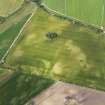
DP 093640 |
RCAHMS Aerial Photography Digital |
Oblique aerial view of the cropmarks of the pits and field boundary, looking W. |
24/7/2010 |
Item Level |
|
 |
On-line Digital Images |
SC 2370614 |
Records of the Ordnance Survey, Southampton, Hampshire, England |
Innesmill, NJ26SE 40, Ordnance Survey index card, Recto |
1958 |
Item Level |
|


