
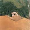
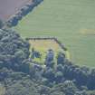
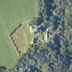
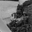
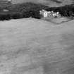
Spynie Palace


Bishops Palace (14th Century)
Site Name Spynie Palace
Classification Bishops Palace (14th Century)
Alternative Name(s) Castle Of Spynie; Spynie Castle; Davie's Tower; Davy's Tower; Palace Of Spynie
Canmore ID 16460
Site Number NJ26NW 10
NGR NJ 23091 65852
NGR Description Centred NJ 23091 65852
Datum OSGB36 - NGR
Permalink http://canmore.org.uk/site/16460


First 100 images shown. See the Collections panel (below) for a link to all digital images.
- Council Moray
- Parish Spynie
- Former Region Grampian
- Former District Moray
- Former County Morayshire
Antiquarian Observation (1857 - 1861)
Mason's marks from Scottish churches, abbeys and castles recorded between 1857 and 1861 on 29 drawings in the Society of Antiquaries of Scotland Collection.
Field Visit (29 November 1962)
The remains of the Palace are fully described by W D Simpson 1927.
There is a slight ditch on the west side of the Palace, but it may be due to recent clearing away at the base of David's Tower; and there would appear to be the remains of a ditch outside the east curtain wall and to the north of the gateway; but W D Simpson (1927) makes no mention of any earthworks in relation to the Palace.
Earthworks surveyed.
Visited by OS (WDJ) 29 November 1962.
Desk Based Assessment (1962)
NJ26NW 10 centred 23091 65852
(NJ 2307 6584) Palace of Spynie (NR)
(Ruins) Davie's Tower (NR)
Chapel (NR)
OS 6" map, Morayshire, 2nd ed., (1906)
Location formerly entered as centred NJ 2307 6584.
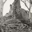
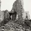
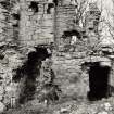
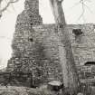
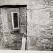
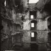
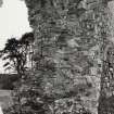
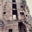
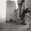
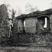
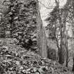
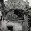
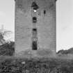
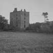
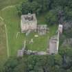
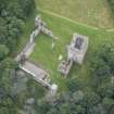
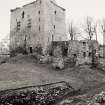
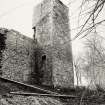
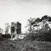
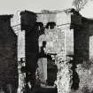
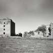
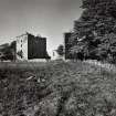
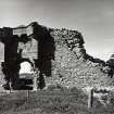
The 'Castle of Spynie', an Episcopal residence, is first mentioned at the end of the 13th century; but no part of the present ruins is of so early a date. The name 'Palace of Spynie' occurs first in 1472, and this authority uses either name interchangeably. The chapel and the adjoining SE tower, are the earliest traceable parts, and date from the end of the 14th century David's Tower, built c. 1461-76 by Bishop David Stewart - hence the name, was completed by 1482 and altered c.1535-73. The decay began in 1690.
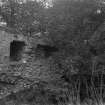
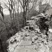
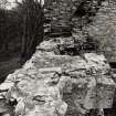
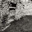
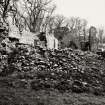
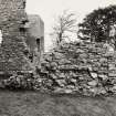
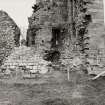
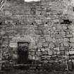
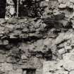
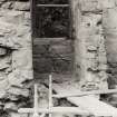
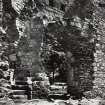
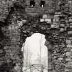
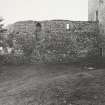
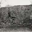
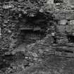
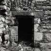
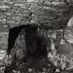
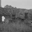
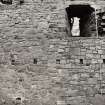
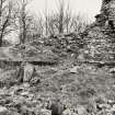
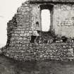
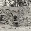
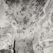
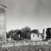
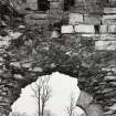
The chief feature is the keep, which measures 62ft 5ins by 44ft 3ins and is about 73ft in height. This keep forms the south-western defence of the large irregular courtyard, enclosed by walls 5ft 3ins thick, with smaller towers at the other three corners. Of these, the tower to the NE is almost completely demolished and its foundations are buried in a mass of rubble. The enceinte walls are now much destroyed, but in places still remain to a height of c.25ft. Against the north, east and west walls were buildings now entirely destroyed; and on the south side was the chapel, correctly oriented and distinguished by its pointed windows. The main gate in the east was defended by a portcullis.
W D Simpson 1927.
Information from Ordnance Survey Index Card.
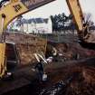
Trial Trench (1986)
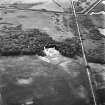
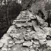
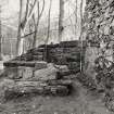
A series of trial trenches revealed vestiges of stone buildings outside the N, E and possibly the S walls of the palace, cobbled roads leading to the E and S entrances, and an outer precinct wall and perhaps a ditch adjacent to the S range, SW tower and W range. 120m W of the palace, on the shore of a drained sea loch, were found a probable drying kiln and a wall, believed to be part of an 18th century cottage.
Sponsor: SDD : HBM
J H Lewis 1986
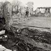
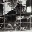
Excavation (1987)
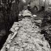
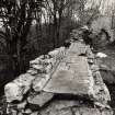
The first major season of excavation was concentrated mainly in the northern sector of the palace enclosure. Little evidence of occupation survived in the main part of the N range (banqueting hall), whereas several constructional and functional changes were apparent in the adjacent area of the Watergate. Although not fully excavated and difficult to interpret, most of these phases were probably associated with service offices.
A diversity of structures beyond the N wall included drains, floor surfaces, a defensive pit outside the Watergate and, adjacent to it, a pavement possibly leading to the harbour.
Sponsor: SDD : HBM
J H Lewis 1987
Excavation (1988)
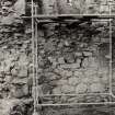
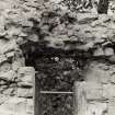
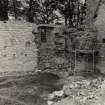
Although little occupational evidence survived, excavation revealed a complex constructional sequence within the S range, including indications of two building phases pre-dating the probably 14th century standing remains. The upper storey has been converted from a hall to a chapel and the ground floor doorway blocked, probably during the late 15 th-early 16th century modifications. Little of the S curtain wall survived but it may once have linked the S range to an early SW corner tower and, later, to its massive extant successor. Beyond this tower and the S range were 1-2 courses of a later boundary wall, perhaps associated with the 16th-17th century re-occupation of the palace.
J H Lewis 1988
Excavation (1989)
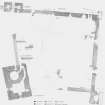
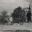
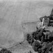
Spynie Palace was the principal residence of the Bishops of Moray from the 13th century until the abolition of episcopacy in the late 17th century. Its ruins are situated 3Km north of Elgin and 5Km from the sea, which formerly extended as far as the palace via the now partially drained Spynie Loch. Trial trenching in 1986 was followed by excavation within the N range and the adjacent watergate area in 1987. Work was completed in the watergate area and within the S range during the following year, but the extensive area between the S range and the massive SW corner tower ('Davy's Tower') was not finished during that season (Discovery Excav Scot 1987; 1988; 1989).
The principal aims of the 1989 season were: to complete the work, started the previous year, outside the S range; excavate; and to investigate the NW corner of the enclosure, at the junction of the N and W ranges.
The 1989 Excavation
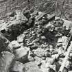
The South Area: Only c5m of the curtain wall (partially excavated in 1988) survived beyond the E face of 'Davy's Tower'. Its 1.80m wide foundations comprised two layers of large, angular rubble, separated by a layer of coarse sand. The curved face of the masonary at the base of the tower's E wall did not extend into the S side of the building and is unlikely to have belonged to an earlier structure, as has been suggested. There were numerous features cut into the sandy subsoil to the E of the tower, including sub-rectangular pits, backfilled with rubble, and several circular postholes, typically 200mm in diameter. Thus far, these pits and postholes have presented no obvious pattern but the proposed northward extension of the excavation area may help resolve the problem. The recent installation of large concrete bases to the E of the tower may have been responsible for the lack of such features further S.
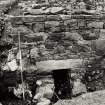
Northwest area: Although excavation was far from complete, several masonary structures were uncovered after the extensive and often deep, overburden was removed from this area. Much of the 2m wide W curtain survived only as rubble foundations or, in places, merely as a spread of mortar and clay. It was also apparent that at least some of the wall's standing masonary was a recent fabrication. The relationship between the N and W ranges is not yet clear although limited investigation suggested that there were two chambers, perhaps separated by a corridor or pend, wikthin the excavated area. To the south, and undoubtedly part of the W range, was a vaulted basement wherein little evidence of occupation survived. On the N side of the area, between the W curtain and the W watergate chamber, was a room measuring c9.0m WE by at least 6.0m wide. Within this basement chamber were remnants of a flagged floor and a stone sided structure which, although only partially excavated. resembled the base of a kiln. However, it is difficult to envisage how such a kiln could have functioned, given that its 2.0m long'flue' terminated against the inside face of the N curtain wall.
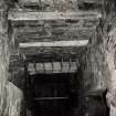
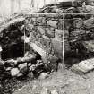
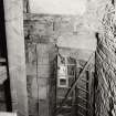
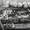
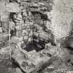
The North Range: The surface of a rock cut pit was exposed at the E end of the N range in 1987 but further investigation had to await the consolidation of the stonework wihtin the building's adjacent somewhat unsafe E gable. Work was resumed in 1989 when the pit was shown to be a 1.1m to 1.6m diameter well, cut to a depth of 8.0m into the bedrock. Only the bottom 1.0m of the shaft was under water in the rather dry weather experienced during the excavation. At a depth of 1.8m there were four courses 1.2m high of a tightly jointed curved ashlar linig, supported on two massive sandstone lintels that spanned faults in the rock. Numerous carved stone blocks, similar to those used in the well's lining, were found within the lower levels of infill, suggesting that the shaft was orginally lined as far as (and probably beyond) the present ground surface. There was no indication that the well had been lined below the level of the lintels. The infill comprised voided rubble, much of it worked sandstone, and dark silts which contained several fragments of leather but few other artefacts. The notable exception, at the base of the shaft, was an almost complete ceramic jug, of probable 17th century date, which suggests the well was still in use towards the end of Spynie's occupation.
(see DES for plan)
Sponsor SDD: HDM
John Lewis 1989
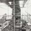
Excavation (1990)
During the fourth major season at Spynie, excavation was concentrated mainly on the W side of the enclosure within a trench measuring approximately 30m NS by 15m EW. In addition, features within and beyond the E curtain were investigated when rubble was cleared from against the wall's exterior.
Although arch-pointed windows and a fireplace at first floor level of the W curtain indicate that there had been a stone-built W range, excavation failed to uncover further positive evidence of such a building. The construction, at a later date, of two barrel-vaulted cellars adjacent to the W curtain probably accounted for this paucity of information. The S vault, apparently the basement of a free-standing building, measured 7m EW by 5.4m NS. Its roof sprang from the building's N and S walls which were 1.1m to 1.3m wide; in contrast the end walls were a mere 0.5m wide. A secondary partition, with an off-centre doorway, divided the cellar into two rooms of unequal size, the E chamber being only 1.5m wide. Scattered spreads of ash and burnt soil were the only evidence of occupation and broken sandstone flags the only remnants of a floor surface.
Beneath the S wall of the cellar were deposits that may have been associated with the occupation of the W range. Cutting the subsoil below these levels was a pit within which was found an intact ceramic jug of 14th or 15th century date. The cellar was separated from the curtain wall to the W and from another barrel-vaulted basement to the N by an L-shaped passage, 1.4m wide, that linked the courtyard with the basement of 'Davy's Tower'. The passage was floored with cobbles and small flags although most of the flooring was missing from the N side. Built into the floor, alongside the curtain wall, was a V-shaped open drain that debouched through the wall.
In the NW corner of the passage and below its stone floor, was the base of a kiln which was walled with clay bonded rubble and floored with sandstone flags. The other vault, to the immediate N of the passage, was the basement of a building set against the curtain wall and still standing to its second storey on the S and W sides. The N and E walls, however, were completely demolished. Measuring 5.3m NS by 8.5m EW internally, the basement was divided into two chambers by a narrow partition wall. Again, there was little surviving evidence of occupation debris or a floor surface, the level of which was c1m below that of the S vault. Between the two vaults and pre-dating the passage were several large post pits, typically 0.5m in diameter, that may have been associated with an early timber W range. The pits were cut into redeposited subsoil that was used to level the slope that descends northwards towards Spynie Loch.
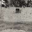
In the NW corner of the palace enclosure were the fragmentary remains of three stone-lined kilns. Two of the kilns may have been contemporary; the third was definitely earlier. None has been fully excavated. Outside the E curtain, removal of the substantial quantities of rubble from against the exterior face of the E curtain wall revealed several, previously undetected, features within the wall. These included: a splayed gunloop, believed to be of mid-16th century date, at the N end of the E range; a latrine chute to the N of the gunloop; and several constructional alterations that were probably associated with modifications to the interior of the N range. A stone-lined drain with a sloping flagstone base, partially uncovered to the N of the E gate, is thought to have been associated with a latrine at first floor level in the E range. Pre-dating the drain but integrated into its masonry, was a narrow wall that abutted the curtain wall and extended eastwards from it beyond the limit of excavation.
(See DES for plan.)
Sponsor: HBM
J Lewis 1990
Excavation (1992)
Limited excavation beyond the SE corner of the enclosure revealed the reamins of a shallow ditch, 7m wide and aligned E/W, that appeared to pre-date all of the extant buildings of the palace. The ditch was levelled during the construction of the S range and the SE corner tower, the massive rubble foundations of the latter extending well into it. Several sherds of 12th-century pottery (from at least three vessels, including one of ?Low Countries proto-stoneware) were recovered from one of the ditch-fills; these appeared to comprise redeposited midden material. Overlying the ditch were deposits derived from the partial collapse of the adjacent buildings; with no indication of a surface contemporary with the occupation of the palace.
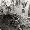
Further S, the drystone, E/W perimeter wall built in 1820 was dismantled to reveal an underlying, clay-bonded and mortar-pointed, rubble wall that survived to a length of 54m. This lower wall is believed to have formed the boundary between the palace and its gardens and orchards.
Two small trenches were opened at first floor level within the SW corner tower to determine the depth (0.20m) of debris that overlay the roof of the cellars below.
Before a safety fence was installed on the N side of the courtyard, trenching was carried out adjacent to the S wall of the N range in an area partially excavated in 1987. The steep, natural slope that once led northwards to Spynie Loch was exposed at several points on the courtyard side of the range.
Sponsor: Historic Scotland
J Lewis 1992.
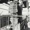
Excavation (1993)
There were three principal areas of investigation during the 1993 season of excavation: the interior of the SW tower ("Davy's Tower"); the SW corner of the courtyard, adjacent to Davy's Tower; and the N side of the courtyard, against the S wall of the N range.
SW Tower. Removal of a thin deposit of modern detritus at first floor level revealed a layer of voided rubble and loose mortar, infilling the space between the underlying vaulted cellars and the flagged floor ofd the hall. Only a few broken flags now project from the inside faces of the walls. In the NE corner of the room, the foundations were revealed of the sole stair that links this level with the upper storeys of the tower. These foundations of massive dry-stone rubble had been built directly upon the vault of the circular basement below.
SW Courtyard. A mound of 19th/20th century rubble was partially removed from the E face of the SW tower in 1988; this task was completed in 1993. This exposed the foundations of the tower, below which were the fragmentary remains of a masonry building that appears to have been destroyed by fire. On the evidence of large quantities of window glass and pottery associated with the demolished building, its construction probably dates to the 14th century. The foundations of another masonry building had been cut into the subsoil nearby. There was no indication as to the function or date of this small building although its resemblance to the truncated walls below the tower suggests that the two structures may have been contemporary.
Between the tower and the S range there were several post holes cut into the subsoil. There was also a number of larger pits, perhaps evidence of a substantial timber structure that pre-dated the extant masonry buildings of the palace.
N courtyard. Limited excavations within this area in 1987 and in 1992 demonstrated that the steep slope against which the S wall of the N range had been built had been levelled, mostly with midden deposits. The proposed rebuilding of a large stretch of the wall prompted the excavation of much of that material which proved to contain huge quantities of animal bones and substantial amounts of pottery. Most of the latter appeared to be of 15th and 16th-century dates.
Sponsor: Historic Scotland.
J Lewis 1993
Excavation (1994)
NJ 228 658. A small (4m by 3m) trench was excavated by Scotia Archaeology Limited in the NW corner of the palace enclosure adjacent to the NW (doocot) tower. The area was partially investigated in 1990 (supra): the imminent construction of a new spiral stair to allow access to the tower required the complete excavation of one of the kilns that had been identified in that year. The kiln bowl measured 1.80m in diameter within clay bonded, rubble walls, 0.60m wide: the flue extended eastwards beyond the trench edge. To the NE of the kiln. and pre-dating it, was a large pit, partially infilled with large boulders and humic material containing very few artefacts or bones.
What appeared to be a pit was partially revealed just outside the W curtain wall during the excavation of an electricity supply trench linking the SW and NW towers. The machine-excavation of the foundations of a new sales point, located 18m SW of the palace, revealed nothing of archaeological interest.
Sponsor: Historic Scotland.
D Reed 1994.
External Reference (June 1997)
The Palace of Spynie (including the chapel and Davie's Tower) are situated on a small spur below a low knoll. The chapel and tower are the earliest traceable parts, dating from the end of the 14th cent. The tower was built in 1461-76 by Bishop David Stewart, altered 1535-73 and fell into decay in 1690.
The chief feature of the palace is the keep which measures about 21m in side and 15m high, and forms the SW defence of the large irregular courtyard; this is enclosed by enceinte walls (measuring 1.8m in thickness and 8m in height, but now largely destroyed) with smaller towers at the other three corners; that to the NE is almost completely demolished and its foundations buried in a mass of rubble. Against the N, E and W walls were buildings (now entirely destroyed) and on the S side was a chapel, correctly orientated and distinguished by its pointed windows. The main (E) gate was defended by a portcullis. There is a slight ditch on the W side of the Palace but it may be due to recent clearance at the base of David's Tower. There are also what seem to be ditch remains outside the E curtain wall and to the E of the gateway.
(Available CUCAP and GRC/AAS air and ground photographic imagery listed).
Information from Aberdeenshire Archaeological Service, June 1997.
NMRS, MS/712/19.
Air photographs: AAS/94/14/G27/8-9.
NMRS, MS/712/21.
Watching Brief (November 2004)
NJ 230 658 Archaeological monitoring was undertaken in November 2004 during the excavation of a foundation trench for a forthcoming storage extension to the rear of the visitor centre, attached to its W side. The area showed much sign of modern disturbance and there were no features or finds of archaeological significance.
Archive to be deposited in NMRS.
Sponsor: Historic Scotland.
C Shaw 2006
Watching Brief (2 March 2011)
NJ 2302 6584 A watching brief was maintained on 2 March 2011 during the excavation of four trenches to house the uprights for a new gate, to the NW of the ticket office to the W of Spynie Palace. The retrieval of a 15th-century pottery sherd indicated the archaeological sensitivity of the area, even at a relatively shallow depth. The excavation also showed that the area had been subject to later landscaping, but still holds high archaeological potential within the layers sealed by this later work.
Archive: RCAHMS (intended)
Funder: Historic Scotland
Kirkdale Archaeology, 2011
Information also reported in Oasis (kirkdale1-171106)
Field Visit (December 2017)
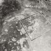
NJ 23091 65852 A walkover survey and topographic survey were carried out, December 2017, within the grounds of Spynie Palace, as part of the Minor Archaeological Services Call-Off Contract, to assess the impact of felling elm trees in the woodland within the palace grounds. Eight monuments associated with the historical use of the palace and grounds were identified and recorded.
Archive: NRHE (intended). Report: Moray HER
Funder: Historic Environment Scotland
Mark Bell – CFA Archaeology Ltd
(Source: DES Volume 19)
External Reference
EXTERNAL REFERENCE:
National Library of Scotland
Nattes Drawings
1 Drawing Vol 1 No 19, 6 Oct
1 Drawing Vol 1 No 20, 5 Oct
Mortar Analysis
NJ 23091 65852 An ongoing programme of landscape, buildings and materials analysis is being carried out at Spynie Palace within the framework of this project. Preliminary buildings analysis at Spynie Palace highlighted that several upstanding structures displayed constructional mortar materials in continuous core, bed and coating contexts, and suggested that all of these materials could be broadly characterised as wood-fired limestone-lime mortars. More focused analysis of several different phases in the SE and W range, however, suggested these materials could be divided into two types, with contrasting limestone, temper and fuel compositions which broadly correlated with building phasing. This included: Type A wood-fired limestone-lime mortars which displayed low limekiln relict concentrations and were generally associated with the earliest structural phases in the Curtain Wall and E Gate; and Type B limestone-lime mortars which displayed high kiln relict concentrations, including a ‘cokey’ fuel of unknown provenance, and were associated with secondary contexts in the SE tower and S and W ranges. These on-site characterisations informed a sampling programme, designed to enable further lab-based investigation of these materials, and the assemblage ultimately included: 18 relict fuel inclusions from various mult-phase masonry contexts, 4 mortar fragments, and 2 relict limestone clasts.
Lab-based analysis of the assemblage included petrographic thin section examination of all mortar and limestone samples. This confirmed that all sampled contexts were indeed bound with limestone-lime mortars, and (with the possible exception of the E gate) these lime source materials were texturally consistent with limestone samples collected from local outcrops. Temper sources were also broadly similar across the three constructional mortar samples, with the coating sample presenting the only significantly contrasting temper profile. Rare marine shell inclusions noted during building survey suggest these materials were quarried from a shoreline source, although this evidence was not noted in finer sections. Microscopic examination of relict fuel samples indicated that the assemblage was completely dominated by wood-charcoal, and that the ‘cokey’ evidence noted during building analysis was the result of fuel vitrification.
Archive: NRHE (intended)
Funder: University of Stirling and Historic Environment Scotland
Mark Thacker – University of Stirling
(Source: DES Volume 19)

