
Knowehead


Building (Post Medieval)(Possible), Enclosure (Post Medieval), Farmstead (Post Medieval), Hut(S) (Post Medieval), Lazy Beds (Post Medieval), Rig And Furrow (Medieval) - (Post Medieval), Stack Stand (Post Medieval)
Site Name Knowehead
Classification Building (Post Medieval)(Possible), Enclosure (Post Medieval), Farmstead (Post Medieval), Hut(S) (Post Medieval), Lazy Beds (Post Medieval), Rig And Furrow (Medieval) - (Post Medieval), Stack Stand (Post Medieval)
Canmore ID 162977
Site Number NY48NE 160
NGR NY 4650 8703
Datum OSGB36 - NGR
Permalink http://canmore.org.uk/site/162977


- Council Scottish Borders, The
- Parish Castleton
- Former Region Borders
- Former District Roxburgh
- Former County Roxburghshire
Field Visit (17 April 1996)
NY48NE 4650 8703
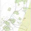
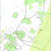
This farmstead, which is situated on the SW side of Park Hill, is named Knowehead on the 1st edition of the OS 6-inch map (Roxburghshire 1862-3, sheet xlv). It comprises a long building and a garden enclosure. The building (LID96 299) which was roofed in 1863 but is now reduced to disturbed faced-rubble footings, measures 14.5m from NNE to SSW by 4.5m transversely internally and is divided into three compartments. A midden mound beside the WNW side of the building may mark the location of an entrance, and also the presence of a byre in the SSW end, which is slightly sunken. The ONB (1857-8) records that the building was one storey high, thatched and in very bad repair, and it was occupied by John Hislop, a shepherd. To the N of the building there are the turf footings of two small huts, the larger (LID96 300) measuring 2.2m by 1.7m internally. The smaller (LID96 351) measures only 0.9m across internally and lies beside a low stone platform that may have been a stack-stand.
The 1st edition OS map depicts a trapezoidal enclosure to the NNE and E of the building, extending as far E as the march dyke that cuts across Kirk Hill and Park Hill. This is the latest of three phases of enclosure with associated cultivation remains, the details of which have been obscured by recent ploughing. The character of the cultivation remains and the sequence between the enclosures can be seen to best effect on RAF vertical aerial photographs (543/RAF/1507 F22: frame no.0204, 3 November 1961). The aerial photographs suggest that the earliest enclosure was probably the largest, lying underneath the enclosure wall depicted on the 1st edition map and extending beyond the march dyke to the E. Subsequently, the enclosure contracted along the E side to the line of a turf bank a short distance E of the march dyke. This enclosure is overlain by the march dyke, onto which the latest enclosure is butted. The earliest visible cultivation remains lie within the surviving portion of the earliest enclosure on the E, and is characterised by shallow furrows set about 10m apart. Cultivation within the middle phase of enclosure comprises lazy-beds about 2m across, set in three distinct blocks, two of which are overlain by the march dyke. The ground within the latest enclosure is smooth in comparison with the ground to the E of the march dyke and the 1st edition map depicts this area as improved.
Between the turf bank marking the E side of the middle phase of enclosure and the march dyke there are the robbed footings of what may be a two-compartment, rectangular building (LID96 352, NY 4665 8709), measuring 14.8m from ESE to WNW by 4.2m internally. The only other feature of note is a track that is depicted on the 1st edition map running up from the crofts to the SE of Newcastleton and skirting the S side of the farmstead; this can be traced in places before disappearing in the boggy ground to the W.
(LID96 299, 300, 351, 352)
Visited by RCAHMS (DCC) 17 April 1996
ONB 1857-8, 7, 79

