
Bute, Kingarth


Building (Period Unassigned), Joiners Shop (Period Unassigned), Saw Pit (Period Unassigned)
Site Name Bute, Kingarth
Classification Building (Period Unassigned), Joiners Shop (Period Unassigned), Saw Pit (Period Unassigned)
Canmore ID 162426
Site Number NS05NE 64
NGR NS 09637 56324
Datum OSGB36 - NGR
Permalink http://canmore.org.uk/site/162426


- Council Argyll And Bute
- Parish Kingarth
- Former Region Strathclyde
- Former District Argyll And Bute
- Former County Buteshire
NS05NE 64 09637 56324
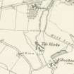
A farmstead, comprising one roofed, one unroofed building, one roofed structure and one enclosure is depicted on the 1st edition of the OS 6-inch map (Argyllshire and Buteshire 1869, sheet ccxv). Three roofed buildings and one enclosure are shown on the current edition of the OS 1:10000 map (1980).
Information from RCAHMS (AKK) 15 October 1998.
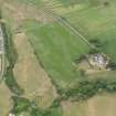
This site is not that of a farmstead, and the unroofed building previously noted was a saw-pit according to the 1st edition of the 25-inch map (Argyllshire and Buteshire 1869, sheet CCXV.11). Today, the site comprises two inhabited buildings (one a one-and-a-half storey cottage, the other a modern house) and a tin shed. According to a local source (I. McArthur, Kilchattan) this was the former site of a joinery shop.
Visited by RCAHMS (AGCH) 19 May 2009.
Desk Based Assessment (15 October 1998)
A farmstead, comprising one roofed, one unroofed building, one roofed structure and one enclosure is depicted on the 1st edition of the OS 6-inch map (Argyllshire and Buteshire 1869, sheet ccxv). Three roofed buildings and one enclosure are shown on the current edition of the OS 1:10000 map (1980).
Information from RCAHMS (AKK) 15 October 1998.
Field Visit (19 May 2009)
This site is not that of a farmstead, and the unroofed building previously noted was a saw-pit according to the 1st edition of the 25-inch map (Argyllshire and Buteshire 1869, sheet CCXV.11). Today, the site comprises two inhabited buildings (one a one-and-a-half storey cottage, the other a modern house) and a tin shed. According to a local source (I. McArthur, Kilchattan) this was the former site of a joinery shop.
Visited by RCAHMS (AGCH) 19 May 2009.

