
Aldroughty


Pit(S) (Period Unassigned), Pit Enclosure (Prehistoric)(Possible), Ring Ditch (Period Unassigned)
Site Name Aldroughty
Classification Pit(S) (Period Unassigned), Pit Enclosure (Prehistoric)(Possible), Ring Ditch (Period Unassigned)
Canmore ID 16222
Site Number NJ16SE 19
NGR NJ 1873 6241
Datum OSGB36 - NGR
Permalink http://canmore.org.uk/site/16222


- Council Moray
- Parish Spynie
- Former Region Grampian
- Former District Moray
- Former County Morayshire
NJ16SE 19 1873 6241.
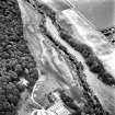
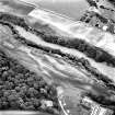
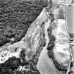
Well-marked circular enclosure, with possibly three internal pits. Photographed as colour print from 2000 feet, in ripening barley crop. Location plan, fig. 21.
J S Bone 1992.

