
Greenshiels


Boundary Dyke(S) (Period Unassigned), Building (Period Unassigned), Farmstead (Period Unassigned), Hut (Period Unassigned), Rig And Furrow (Medieval) - (Post Medieval), Sheepfold (Period Unassigned), Structure(S) (Period Unassigned)
Site Name Greenshiels
Classification Boundary Dyke(S) (Period Unassigned), Building (Period Unassigned), Farmstead (Period Unassigned), Hut (Period Unassigned), Rig And Furrow (Medieval) - (Post Medieval), Sheepfold (Period Unassigned), Structure(S) (Period Unassigned)
Alternative Name(s) Greenshiel Sike
Canmore ID 162060
Site Number NY49SE 17
NGR NY 4851 9059
Datum OSGB36 - NGR
Permalink http://canmore.org.uk/site/162060


- Council Scottish Borders, The
- Parish Castleton
- Former Region Borders
- Former District Roxburgh
- Former County Roxburghshire
Field Visit (26 March 1998)
NY49SE 17 4851 9059
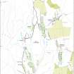
To the W of Ryedale Burn and on either bank of the steeply cut Greenshiels Sike there are series of structures comprising a farmstead, a sheepfold, several small turf structures, a building, two phases of boundary dyke, some earthen-banked fields and patches of rig.
The area is defined on the W by a boundary-dyke, which extends from a small unnamed tributary of the Ryedale Burn on the N (NY 4861 9099) over a distance of about 900m to a boggy sump at the head of another unnamed tributary of the burn to the S (NY 4858 9013). The boundary comprises an earthen bank up to about 0.6m high, with an external ditch, on its W side, and tends to run along the contour from one burn to another. It is best-defined where it cuts into the rock outcrops between Tailor's Sike and Greenshiels Sike, at the N end of which, as it descends into the gully of the burn, it bifurcates. On the inside of the dyke at this point there are several narrow rigs (NY 4855 9086). At its S end another dyke of similar construction continues SSW from the boggy sump in the direction of the Ralton Burn (see NY48NE 193.00 for description). The return between the two is enclosed by another dyke of similar construction, which runs in an arc from the one to the other (NY 4856 9029 to NY 4845 9005). The continuation of the boundary at the N is described under NY49SE 19. The overall area enclosed by this boundary is difficult to calculate as parts of the system have been destroyed by later farming and forestry. A later earthen bank, which overlies the boundary dyke, runs from the Ryedale Burn in the E over a distance of about 400m to an unnamed burn in the W (NY 4875 9032 to NY 4838 9047).
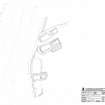
The farmstead, which is situated on a terrace immediately E of the boundary dyke, comprises four buildings and an enclosure. What may be a much reduced fifth building (LID96 204) and subsquare turf enclosure lie on a lower terrace to the NE, which is connected to the upper terrace by a trackway that cuts into the slope and runs past one of the buildings of the farmstead. The upper group of buildings is probably of at least two phases. Three of them, which are all aligned on the same axis from NE to SW and post-date the boundary dyke (LID96 201, 202, 208), probably form one phase and the fourth building (LID96 203), to the N, which lies within the boundary dyke, may be earlier. Of the group of three, two lie adjacent to each other, while the third is a little way to the S (LID96 202), overlying an enclosure, which itself appears to have been built over the boundary dyke at its N end. Were this enclosure to be coeval with the other two buildings of the group, the southernmost building would represent a third phase.
The buildings range in size from 11.5m to 21.5m in length by between 6.3m and 7.4m in breadth over turf, or grass-grown stone footings spread to 1.5m in thickness and up to 0.4m in height. Entrances are in one side and two of the buildings (LID96 201, 208) belonging to the group of three, have hollows in their NE end, suggesting that they are byre-houses. The northerly of the two adjacent buildings of this group has suffered from collapse or robbing along its SE side and the trackway runs past the N side (LID96 208). The southerly of the two has a small turf hut built against its SE side to the E of the entrance (LID96 201). The northernmost building (LID96 203) differs from the other buildings in having one end rounded and the other squared, as opposed to the rectangular plan of the other buildings, but it too has a hollow in the N end of the interior, and it has a drainage gully around the outside of the rounded end. The possible fifth building (LID96 204), despite its indefinite plan, is also probably of this shape, and it has a slight hollow at its NE end.
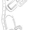
To the E of the Greenshiels Sike there is a sheepfold (LID96 209), which overlies the WNW end of the boundary dyke. It measures 10m from WNW to ESE by 3.6m transversely within turf banks spread to 2.3m in thickness and about 0.3m in height; it has an entrance in the ESE end protected by a baffle wall extending in a dog leg from the NE corner. Two more turf structures lie immediately to the SW, the larger inside the boundary dyke and the smaller outside. Both appear to be open-ended, a rank growth of rushes obscures the larger structure. This latter structure (LID96 206) is big enough to be a building.
There are two other turf huts at the site. The one, measuring 4.7m by 2.7m internally, lies on the E edge of the gully of the Greenshiels Sike (LID96 205, NY 4861 9077). The other is situated about 500m to the SSE on a rig-covered terrace to the W of the Ryedale Burn (NY 4876 9020, LID96 207); it measures 6.6m from ENE to WSW by 3.5m transversely within a turf bank spread to 1.5m in thickness and up to 0.25m in height, and there is with an entrance on the NNW.
There are several expanses of curvilinear rig between the primary phase of the boundary dyke and the Ryedale Burn, and another patch on the E bank (NY 4885 9055), with a field-bank delimiting its N extent. All but two of the areas of rig (NY 4855 9050) are enclosed within earthen banks. The most clearly defined rig lies within an irregularly-shaped enclosure, the ends of the rig tapering considerably in order to fit the limited space (NY 4873 9058).
Greenshiels is listed in a rental of 1376 (Reg. Hon. Morton 1853) and in a Crown rental of 1541 (ERS 1897, 697-702). A settlement is depicted on Blaeu (1654) on a burn S of Over Foulshiels. It does not appear in the Hearth Tax ((National Archives of Scotland (SRO) E69/21/1) or any later documentation and appears to have been abandoned in the course of the 17th century.
(LID96 201-209).
Visited by RCAHMS (PJD) 26 March 1998
J Blaeu 1654; Reg. Hon. Morton 1853; J Stuart and G Burnett 1897
Measured Survey (4 March 1998)
RCAHMS surveyed the farmstead at Greenshiels Sike with plane-table and self-reducing alidade on 4 March 1998 at a scale of 1:250. The resultant plan was redrawn in ink and published at a scale of 1:500.

