
Toft Knowes


Field System (Period Unassigned), Pen(S) (Period Unassigned), Rig And Furrow (Medieval) - (Post Medieval)
Site Name Toft Knowes
Classification Field System (Period Unassigned), Pen(S) (Period Unassigned), Rig And Furrow (Medieval) - (Post Medieval)
Canmore ID 161997
Site Number NY49NE 22.03
NGR NY 4973 9559
Datum OSGB36 - NGR
Permalink http://canmore.org.uk/site/161997


- Council Scottish Borders, The
- Parish Castleton
- Former Region Borders
- Former District Roxburgh
- Former County Roxburghshire
Field Visit (17 April 1996)
NY49NE 22.03 4973 9559
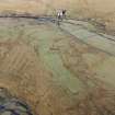
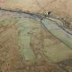
This field-system extends over an area measuring about 700m from NW to SE by 350m transversely along the ridge called Tofts Knowes. It comprises at least three discrete blocks of small rectilinear fields delimited by earthen banks. One of the blocks includes a row of pens on the boundary between two fields (NY 4969 9558). What may have been another block of fields has been reduced to a field-bank along the top of the modern fields to the NE, with the stubs of at least two banks dropping down the slope. The rig, which has been much reduced by more recent cultivation, extends beyond the fields to the N and E.
Visited by RCAHMS (PJD) 17 April 1996

