
Gordonstoun House, Windmill Dovecot


Dovecot (18th Century) - (19th Century), Windmill (18th Century)
Site Name Gordonstoun House, Windmill Dovecot
Classification Dovecot (18th Century) - (19th Century), Windmill (18th Century)
Alternative Name(s) Gordonstoun School; Gordonstoun House Polices
Canmore ID 16114
Site Number NJ16NE 7.07
NGR NJ 18809 69418
Datum OSGB36 - NGR
Permalink http://canmore.org.uk/site/16114


- Council Moray
- Parish Drainie
- Former Region Grampian
- Former District Moray
- Former County Morayshire
NJ16NE 7.07 18809 69417.
(NJ 1881 6941) Dovecot (NAT)
OS 25" map, (1905)
On the earliest map found (Information from Johnston county map of Nairn 1845) the words 'Wind Mill' appear immediately above Gordonstoun, in the area of the dovecot.
Information from J Howdle, 1 October 1962.
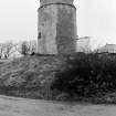
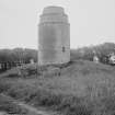
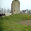
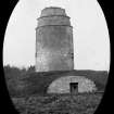
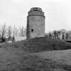
This dovecot is 35ft high and about 50ft in circumference, with three string courses. It stands level with the surrounding ground, but around its base is a circular mound 8-10ft high which covers two vaults - one on the north, and one on the south side; the roof of the latter has fallen in. The vaults are of arched masonry 19ft long 10ft wide with doors about 5ft wide.
A corn mill driven by the wind is said to have existed here (Information from J W Denoon, Lossiemouth)
R Douglas 1931.
The entrance to the dovecot is through the stone vaults beneath it; it appears to be a converted windmill.
(Information from MS 'Old Dovecots of Scotland' by A N Robertson, p367)
The dovecot is generally as described by R Douglas (1931) The vaults are now filled in and grassed over, rendering the interior of the structure inaccessible. There seems little doubt that this was formerly a windmill before converted to use as a dovecot.
Visited by OS (R D L) 30 November 1962.
Windmill (remains of) [NAT]
OS 1:10,560 map, 1969.

