
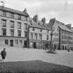
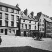
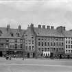
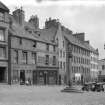
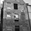
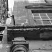
Stirling, Broad Street, General


General View
Site Name Stirling, Broad Street, General
Classification General View
Canmore ID 160158
Site Number NS79SE 215
NGR NS 79305 93718
NGR Description From NS 79247 93745 to NS 79368 93687
Datum OSGB36 - NGR
Permalink http://canmore.org.uk/site/160158


- Council Stirling
- Parish Stirling
- Former Region Central
- Former District Stirling
- Former County Stirlingshire
NMRS NOTES:
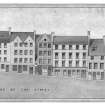
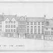
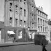
30-38 Broad Street
Precise location uncertain at time of upgrade 06.02.04
NMRS NOTES:
Current day numbering 2-10 Broad Street replace previously demolished buildings. These former buildings are depicted in NMRS drawings STD 143/1, STD 143/6, STD 153. Please refer to collections page. They also depict the corner building of Broad Street with St Mary's Wynd. Former buildings depicted on Epoch 3, 1:2500 Stirlingshire, 1917-18.
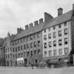
Photographic Survey (1923)
Photographic survey of buildings on Broad Street, Stirling, by the Ministry of Works 1923, prior to demolition in 1926,
Photographic Survey (1957)
Photographic survey of buildings on Broad Street and Baker Street, Stirling, by the Scottish National Buildings Record in 1957

