
Bute, Kilchattan Brick And Tile Works


Brick And Tile Works (Period Unassigned)
Site Name Bute, Kilchattan Brick And Tile Works
Classification Brick And Tile Works (Period Unassigned)
Canmore ID 158613
Site Number NS05NE 66
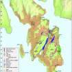
NGR NS 09913 56316
Datum OSGB36 - NGR
Permalink http://canmore.org.uk/site/158613


- Council Argyll And Bute
- Parish Kingarth
- Former Region Strathclyde
- Former District Argyll And Bute
- Former County Buteshire
NS05NE 66 09913 56316
NS 099 562 House; later industrial use.
Sponsor: Buteshire Natural History Society.
A Hannah 1997
NS 098 562 Site 27 Glaic/Butt Intluik
On the right bank of the mill burn, at the corner of the gun club field, stand three walls of a mortared rectangular building. Partially repaired with bricks and concrete, it may have been used in conjunction with the tilery, but possibly pre-dated this, and is on the site of the butt known in the 18th century as Glaic or Intluik (the hollow).
Proudfoot and Hannah 2000
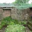
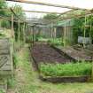
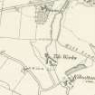
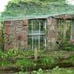
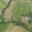
All that is now readily visible of Kilchattan brick and tile works (1849-1927) is a building that formed the apex at the N end of two long drying sheds, which has been incorporated into a modern kitchen garden. The building, which may have been a smith's workshop or engine house (see MS/500/43/2), measures 6.7m from N to S by 5.4m transversely within coursed, mortared rubble walls that stand up to 3m in height. There is an entrance and flanking windows in the W side and in the N end there is a blocked window and a vertical flue. The S end-wall is missing and the interior of the building now contains a series of raised vegetable beds. A kiln, which is depicted on the 1st edition of the Ordnance Survey 6-inch map (Buteshire 1869, sheet CCXV) standing immediately SSE of this building, has been reduced to a large mound of rubble.
The small farmstead which formerly stood on the site (Butt-in-gloik) is recorded elsewhere (NS05NE 60).
Visited by RCAHMS (AGCH) 19 May 2009.
NS05NE 66 09913 56316
Depicted on the 1st and 2nd editions of the O.S. 6-inch maps (Argyllshire), 1869, 1896, sheet ccxv, SE.
Information from RCAHMS (SM), 21 February 2000.
All that is now readily visible of Kilchattan brick and tile works (1885-1915) is a building that formed the apex at the N end of two long ranges, which has been incorporated into a modern kitchen garden. The building, which may have been a smith's workshop (see MS/500/43/2), measures 6.7m from N to S by 5.4m transversely within coursed, mortared rubble walls that stand up to 3m in height. There is an entrance and flanking windows in the W side and in the N end there is a blocked window and a vertical flue. The S end-wall is missing and the interior of the building now contains a series of raised vegetable beds. A kiln, which is depicted on the 1st edition of the Ordnance Survey 6-inch map (Buteshire 1869, sheet CCXV) standing immediately SSE of this building, has been reduced to a large mound of rubble.
Visited by RCAHMS (AGCH) 19 May 2009.
Reference (1885 - 1980)
Reference (1955)
Field Visit (1991 - 1999)
NS 099 562 House; later industrial use.
Sponsor: Buteshire Natural History Society.
A Hannah 1997
NS 098 562 Site 27 Glaic/Butt Intluik
On the right bank of the mill burn, at the corner of the gun club field, stand three walls of a mortared rectangular building. Partially repaired with bricks and concrete, it may have been used in conjunction with the tilery, but possibly pre-dated this, and is on the site of the butt known in the 18th century as Glaic or Intluik (the hollow).
Proudfoot and Hannah 2000
Field Visit (19 May 2009)
All that is now readily visible of Kilchattan brick and tile works (1885-1915) is a building that formed the apex at the N end of two long ranges, which has been incorporated into a modern kitchen garden. The building, which may have been a smith's workshop (see MS/500/43/2), measures 6.7m from N to S by 5.4m transversely within coursed, mortared rubble walls that stand up to 3m in height. There is an entrance and flanking windows in the W side and in the N end there is a blocked window and a vertical flue. The S end-wall is missing and the interior of the building now contains a series of raised vegetable beds. A kiln, which is depicted on the 1st edition of the Ordnance Survey 6-inch map (Buteshire 1869, sheet CCXV) standing immediately SSE of this building, has been reduced to a large mound of rubble.
Visited by RCAHMS (AGCH) 19 May 2009.

