
Portmahomack, Tarbatness Road, Tarbat West Church


Burial(S) (Medieval) - (Post Medieval), Church (Post Medieval), Monastic Settlement (Early Medieval)
Site Name Portmahomack, Tarbatness Road, Tarbat West Church
Classification Burial(S) (Medieval) - (Post Medieval), Church (Post Medieval), Monastic Settlement (Early Medieval)
Alternative Name(s) Tarbat Old Parish Church; Old Tarbat Parish Church
Canmore ID 15662
Site Number NH98SW 4
NGR NH 91485 84020
Datum OSGB36 - NGR
Permalink http://canmore.org.uk/site/15662


First 100 images shown. See the Collections panel (below) for a link to all digital images.
- Council Highland
- Parish Tarbat
- Former Region Highland
- Former District Ross And Cromarty
- Former County Ross And Cromarty
Portmahomack, Tarbat carved stones (TR 1-264), Ross and Cromarty
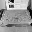
Early medieval carved stones from the churchyard at Tarbat Parish Church have been recorded since the eighteenth century, and nine were included in Allen & Anderson’s volume published in 1903. Another eleven stones were found in the twentieth century, and following Professor Martin Carver’s excavations of 1996 to 2007, the total has increased to 264. Many of these are very small fragments and they have not been given individual entries in Canmore. As many as 230 of the 264 stones were found during excavation in the Glebe Field south-west of the church, and most of them are thought to have belonged to one large monument bearing panels of ornament. Overall the collection includes parts of highly decorated cross-slabs, plain cross-slabs, and fragments of church furniture and architectural pieces. Those included here individually may be found under NH98SW 14.01 to 14.40.
Allen & Anderson 1903, pt 3, 73-5, 88-95; Carver et al 2017, 148.
Desk-based information compiled by A Ritchie 2018
NH98SW 4.00 91485 84020
Tarbat West Church [NAT]
OS (GIS) MasterMap, July 2009.
NH98SW 4.01 NH 9145 8402 Trough quern
NH98SW 4.02 Centred NH 91502 84033 Churchyard (Old Tarbat Burial-ground)
NH98SW 4.03 NH 9153 8402 Dingwall and Mackenzie Monument (Churchyard)
For 1889 discovery of silver hoard in churchyard (NH c. 915 840), see NH98SW 8.
For former 'Danish' cross-slab, see NH98SW 14.
For enclosure (NH 915 840), see NH98SW 25.
For associated enclosure-ditch (location cited as NH 9145 8380) and associated excavations , see NH98SW 38.
Not to be confused with nearby Tarbat Free Church (NH 91343 84096), for which see NH98SW 46.
Not to be confused with (successor and present) Tarbat Parish Church (NH 91619 84460), for which see NH98SW 68.
Although partly rebuilt in 1756, the main block of this T-plan church, which was dedicated to St Colman, retains its medieval E-W orientation, and underneath the E end of the church is a vaulted crypt, first described in the early 18th century. (For cross-slabs etc. found in the vicinity, see NH98SW 8 and NH98SW 14 -16.)
New Statistical Account (NSA) 1845; Orig Paroch Scot 1855; W Macfarlane 1906-8; I B Cowan 1967; A D S Macdonald and L R Laing 1970; RCAHMS 1979; G Stell 1986.
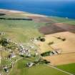
NH 915 839 The Tarbat Discovery Programme is a field research programme designed to explore the society and economy of the northern Picts. The work is currently concentrated at the site of St Colman's Church, or Tarbat Old Church, just outside Portmahomack on Tarbat Ness, Easter Ross.
Tarbat Old Church has produced more than 20 fragments of 9th-century sculpture, including the well-known Latin inscription. In 1984, an enclosure ditch (NH98SW 38) encircling the church and enclosing about 6ha was discovered from the air, and in 1991 this ditch was tested by Jill Harden and its primary fill radiocarbon dated to the 2nd-6th century AD. A major evaluation followed from 1994-6, in which the extent and character of the settlement was estimated, primarily by means of a 'strip and map' technique in which large parts of the enclosure were stripped of topsoil, mapped and reburied without damage. The result of the evaluation was to show that the site contained buildings, including a 'bag-shaped' building and a souterrain, and evidence for early industry. The ditch itself may have been defensive but its main function appeared to be as a water-collector. The church of St Colman, which is 17th century and later in its elevation, had signs of preceding medieval phases.
The excavation programme began in 1997 with the excavation of St Colman's Church in advance of its development as a visitor centre. No Pictish phase was securely contacted, but the first church, a simple rectangular building, probably 12th century in date, incorporated a number of fine pieces of 9th-10th-century sculpture, including the 'Boar' stone which was a sarcophagus lid with panelled boar- and lion-like animals in high relief, and a number of simple cross slabs. The church was extended and acquired a crypt, probably in the 13th century. In the late 16th century the crypt was refashioned with a vault and a N aisle was built. Into the vault of the crypt was built the 'Monk' stone, a fine 9th-century piece which featured a row of standing clerics and a rampant beast. It derived from a very much larger standing slab, which probably included the inscribed stone now in the National Museum. The excavation within the church also produced a remarkable sequence of burials, beginning with cist graves, continuing with 'pillow' graves using head-support stones, and then burials in coffins. The state of conservation of bone and wood is good and often exceptional. Casual finds in post-medieval debris include a carved stone ball of Neolithic/Bronze Age date.
The excavation season continued with work in the Glebe Field, where a car park is to be constructed. This sector has now been shown to contain a stratified sequence some 400mm deep, which should cover the whole of the Early Historic period. The medieval phases currently under excavation include rectangular buildings, stone platforms as yet unidentified, hearths, gullies, and deep pits with good assemblages of medieval pottery and metalworking debris. The animal bone is plentiful and in very good condition.
Sponsors: Heritage Lottery Fund, York University, Tarbat Historic Trust, Highland Council.
M Carver, A Roe and J Garner-Lahire 1997
NH 914 839 The Tarbat Discovery Programme is a field research project designed to explore the society and economy of the northern Picts (Carver, Roe and Garner-Lahire 1997). The 1998 season included the excavation of a small trench on the eastern edge of a sample area in the Glebe Field. This 2 x 3m trench was excavated to house an oil tank, and offered a useful opportunity to examine the full stratigraphic sequence of this area.
Below the ploughsoil a sequence of pits, gullies and dumps were encountered which clearly related to the medieval metalworking phase dissected in the area in previous seasons. Beneath this activity and its associated buried topsoil, a series of levelling deposits were found to cover an uneven layer of windblown sand, which in turn sealed a fire-related destruction horizon. This destruction appeared to represent the end of a long period of settlement suggested by the presence of a deep and complex series of occupation layers which contained a structural sequence of substantial stone-lined drains, a soakaway, and possibly the edge of a metalworking related structure.
The above sequence was contained within c 1.5m of stratigraphy, although several of the early structures cut through a layer of apparently naturally deposited sand to a depth of almost 2m, revealing two deeply buried soils at this level. Dating is problematic as the only datable artefacts, in the form of green-glazed pottery, were found in the latest deposits. Samples for radiocarbon dating were recovered from many deposits throughout the sequence and it is hoped that the resulting dates will provide a basic chronology for this rich and deep sequence.
Work continued completing the excavation and recording of the medieval metalworking phase composed of numerous hearths and related features. A substantial terrace wall was revealed after the removal of dumps of soil and metalworking debris. This terrace appears to be associated with the metalled road which runs down the site to the remains of a building or well surrounded by metalled surfaces.
Reused as the lining for a drain associated with the medieval metalworking was a fragment of sculpture carrying a picture of animals carved in relief. This stone, which dates to the 9th century, is part of a carved stone found last year.
Excavation in an area outside the enclosed settlement area defined possible prehistoric activity including a large open-ended oval enclosure containing a charcoal and ash-filled central feature flanked by six substantial pits. No dating evidence was recovered from the sample excavation of this enclosure ditch and the interpretation of this feature remains uncertain, although the possibility that it represents the remains of an early prehistoric funerary monument has not been discounted.
Post-excavation work currently being undertaken for the church has so far identified nine phases of activity. The earliest phase comprised a cemetery of cist burials which was superseded by burials with stone settings around the head, probably marked with the 9th-10th century gravemarkers found reused in the foundations of the earliest stone church. Further phases trace the development of the church from its pre-12th-century beginnings to the 20th century when it was abandoned.
The restoration of Tarbat Old Church is now complete and the display is being prepared for opening in the summer of 1999.
Sponsors: Tarbat Historic Trust, University of York, Highland Council, European Regional Development Fund, Heritage Lottery Fund.
M Carver, J Garner-Lahire and A Roe 1998.
NH 914 839 Excavation continued at the site of St Colman's Church, Portmahomack, in 1999, 2000 and 2001 (DES 1998, 63). The site is now coming into focus as an 8th-century settlement which had a cemetery (under the present church), with a large number of stone memorials featuring a variety of Pictish sculpture, and (SW of the church) a group of workshops flanking a road in which bronze and precious metals, glass, wood, fine leather (and perhaps even vellum) were being used in manufacture. Further S, a dam probably to form a pool for a mill is under investigation. Further S still, a large building, bag-shaped in plan, was partially excavated in 2001; it appears to have been a frame-building supported by pairs of aisle-posts made of squared timbers. Other features suggest that it stood in a farm area. A series of ditches surround the settlement, suggesting a vallum.
Early medieval radiocarbon dates so far received are mid-6th century for a cist burial in the cemetery, and early 8th century for a wattle revetment of the enclosure ditch. Numerous finds associated with the workshops suggest that these flourish with the sculpture in the 8th century. The identification of the settlement as a monastery is based on the plan of the vallum, the character of the sculpture, and the fact that the first phase of burials were mainly those of middle-aged men. Links with both Iona and Jarrow are strongly signalled by the finds. Between the 9th-12th century, many gravemarkers were disturbed or broken up and a fire affected all the workshop area. Nevertheless, the road, the farm and some manufacturing continued to function into the 10th century and beyond.
The sculpture in the Tarbat area suggests that, in the 8th century at least, the Tarbat peninsula was an integrated unit, perhaps the territorium of the monastery at Portmahomack and possibly using the famous monuments at Nigg, Shandwick and Hilton as boundary markers. It is planned to test these and other ideas in our survey programme. So far we have undertaken some preliminary work at the site of St Mary's Chapel at Hilton (for Tain and Easter Ross Civic Trust) in advance of the erection of the replica, and mapped there what is probably the medieval village of Cadboll Fisher. Excavation and survey are planned to continue from July to September in 2002-2004.
The Tarbat Discovery Centre, displaying the results of the excavations and profiling the Picts on the Tarbat peninsula was opened by Prince Charles in September 2000.
The Tarbat Discovery Programme warmly welcomes participation from students and volunteers from Scotland and beyond. For more details please visit our website at www.york.ac.uk/depts/arch/staff/sites/tarbat/.
Sponsors: Tarbat Historic Trust, University of York, Highland Council, Heritage Lottery Fund, National Museums of Scotland.
M Carver 2001
NH 914 839 Four further seasons of archaeological excavation were undertaken at the site of St Colman's Church, Portmahomack, during the summers of 2002 to 2005 inclusive (DES 2001, 64-5, PSAS 134, 2004, 183-200, Med Archaeol 48, 2004, 1-30). The 2002 to 2004 seasons saw the completion of the southern area of excavation, specifically the investigation of the 'bag-shaped' building and associated features. A radiocarbon date from the hearth of the building returned a date in the 18th century, and a nearby structure, reported previously as a souterrain, was revealed to be a wood-lined well.
Between 2003 and 2005, the investigations of the layout and character of the craftworking area to the N of the site continued. During the 2003 season, the central road was found to have been flanked by a stone-built flue and culvert, associated with a succession of large road-side ditches. To the E of the road, evidence for non-ferrous metalworking was revealed, in the form of clay- and stone-built hearths, associated with an assemblage of crucibles, moulds, metal droplets and stone tools. The craftworking area is situated on a terrace adjacent to the mill dam, and evidence for a burnt wattle revetment, associated with a site-wide fire, was excavated. Stratigraphic evidence suggested that metalworking had occurred both before and after the major episode of burning across the craftworking zone.
To the W of the road, work continued in the leatherworking area, and in 2005 the remains of a turf- and timber-built structure with associated yard and tanning area were defined. A stone-built hearth was excavated inside the structure, and thought to relate to leatherworking.
In the northern part of the craftworking zone, excavation of a rectangular feature revealed a long cist, containing the well preserved remains of an adult male, orientated W-E.
The project archive is currently in the care of the Department of Archaeology, University of York, the NMS and Field Archaeology Specialists Ltd, York. All finds are reported to the Treasure Trove Advisory Panel, and all excavated material has been awarded to the NMS. Data Structure Reports for 2003, 2004 and 2005 have been deposited with the NMR and with Historic Scotland, and can be found online at www.york.ac uk/depts/arch/staff/sites/tarbat.
Sponsor: National Museums of Scotland, Historic Scotland, Ross and Cromarty Enterprise, University of York.
Martin Carver and Cecily Spall, 2006.
NH 914 839 The 2006 season consisted of eight weeks' excavation between May and July, concentrating on the northern zone of Sector 2, the area closest to the churchyard of St Colman's Church. Investigation of a leatherworking building (Structure 9) identified in 2005 continued and several postholes were identified and excavated as well as the final excavation and recording of the building's central hearth. A possible threshold was identified made of layered linear sandstone slabs suggesting an entrance from the NE. The threshold was associated with an area of metalled surface, kerbed with small Old Red Sandstone detail.
To the S of Structure 9, work continued to concentrate on the excavation of two roadside ditches and associated features. To the W, a stone baffle had been set into the terminus of the western ditch, which had been disused by dumping of ash deposits to level the area. To the E, the earliest form of the roadside ditch was achieved and consisted of a broad shouldered ditch with a vertical-sided slot in the base filled with cobbles to aid drainage. This issued into a small stone-lined cistern set slightly to the E of the ditch, but with connecting gully. To the E a precursor of the eastern drainage system was identified and will be the subject of investigation during 2007.
Further to the E of the road system two features were identified and excavated. The first, an earthen bank with boulder core was excavated and appeared to delineate an area used for butchery to the W and a further area of possible leatherworking to the E. The second, a large well-like feature, was partially excavated and appeared to be wood-lined. The feature was associated with an area of paved hard standing and was associated with a pumice rubber, small iron knife and various skin burnishing or smoothing stones.
The project archive is currently in the care of the Department of Archaeology, University of York, the NMS and Field Archaeology Specialists Ltd, York. All finds are reported to the Treasure Trove Advisory Panel, and all excavated material has been awarded to the NMS. Data Structure Reports for 2003, 2004 and 2005 have been deposited with the NMR and with Historic Scotland, and can be found online at www.york.ac uk/depts/arch/staff/sites/tarbat.
Sponsor: National Museums of Scotland, Historic Scotland, Ross and Cromarty Enterprise, University of York.
Martin Carver and Cecily Spall, 2006.
Field Visit (September 1977)
Tarbat, Church NH 914 840 NH98SW 4
The present parish church, built in 1756 and dedicated to St Colman, is probably the latest of several which have occupied this site from at least as early as 1255. In 1899 a Viking silver hoard (NMAS I L 272-81) was discovered during the digging of a grave.
RCAHMS 1979, visited September 1977
(NSA, xiv, Ross and Cromarty, 461; OPS 1851-5, ii, 434; Shetelig 1940-54, ii, 109-110; Cowan 1967, 195; Macdonald and Laing 1970, 138; OS Record Card NH 98 SW 8)
Excavation (2002 - 2005)
NH 914 839 Four further seasons of archaeological excavation were undertaken at the site of St Colman's Church, Portmahomack, during the summers of 2002 to 2005 inclusive (DES 2001, 64-5, PSAS 134, 2004, 183-200, Med Archaeol 48, 2004, 1-30). The 2002 to 2004 seasons saw the completion of the southern area of excavation, specifically the investigation of the 'bag-shaped' building and associated features. A radiocarbon date from the hearth of the building returned a date in the 18th century, and a nearby structure, reported previously as a souterrain, was revealed to be a wood-lined well.
Between 2003 and 2005, the investigations of the layout and character of the craftworking area to the N of the site continued. During the 2003 season, the central road was found to have been flanked by a stone-built flue and culvert, associated with a succession of large road-side ditches. To the E of the road, evidence for non-ferrous metalworking was revealed, in the form of clay- and stone-built hearths, associated with an assemblage of crucibles, moulds, metal droplets and stone tools. The craftworking area is situated on a terrace adjacent to the mill dam, and evidence for a burnt wattle revetment, associated with a site-wide fire, was excavated. Stratigraphic evidence suggested that metalworking had occurred both before and after the major episode of burning across the craftworking zone.
To the W of the road, work continued in the leatherworking area, and in 2005 the remains of a turf- and timber-built structure with associated yard and tanning area were defined. A stone-built hearth was excavated inside the structure, and thought to relate to leatherworking.
In the northern part of the craftworking zone, excavation of a rectangular feature revealed a long cist, containing the well preserved remains of an adult male, orientated W-E.
The project archive is currently in the care of the Department of Archaeology, University of York, the NMS and Field Archaeology Specialists Ltd, York. All finds are reported to the Treasure Trove Advisory Panel, and all excavated material has been awarded to the NMS. Data Structure Reports for 2003, 2004 and 2005 have been deposited with the NMR and with Historic Scotland, and can be found online at www.york.ac uk/depts/arch/staff/sites/tarbat.
Sponsor: National Museums of Scotland, Historic Scotland, Ross and Cromarty Enterprise, University of York.
M Carver and C Spall 2005
Excavation (May 2006 - June 2006)
NH 914 839 The 2006 season consisted of eight weeks excavation between May and July, concentrating on the northern zone of Sector 2, the area closest to the churchyard of St Colman's Church. Investigation of a leatherworking building (Structure 9) identified in 2005 continued and several postholes were identified and excavated as well as the final excavation and recording of the building's central hearth. A possible threshold was identified made of layered linear sandstone slabs suggesting an entrance from the NE. The threshold was associated with an area of metalled surface, kerbed with small Old Red Sandstone detail.
To the S of Structure 9, work continued to concentrate on the excavation of two roadside ditches and associated features. To the W, a stone baffle had been set into the terminus of the western ditch, which had been disused by dumping of ash deposits to level the area. To the E, the earliest form of the roadside ditch was achieved and consisted of a broad shouldered ditch with a vertical-sided slot in the base filled with cobbles to aid drainage. This issued into a small stone-lined cistern set slightly to the E of the ditch, but with connecting gully. To the E a precursor of the eastern drainage system was identified and will be the subject of investigation during 2007.
Further to the E of the road system two features were identified and excavated. The first, an earthen bank with boulder core was excavated and appeared to delineate an area used for butchery to the W and a further area of possible leatherworking to the E. The second, a large well-like feature, was partially excavated and appeared to be wood-lined. The feature was associated with an area of paved hard standing and was associated with a pumice rubber, small iron knife and various skin burnishing or smoothing stones.
The project archive is currently in the care of the Department of Archaeology, University of York, the NMS and Field Archaeology Specialists Ltd, York. All finds are reported to the Treasure Trove Advisory Panel, and all excavated material has been awarded to the NMS. Data Structure Reports for 2003, 2004 and 2005 have been deposited with the NMR and with Historic Scotland, and can be found online at www.york.ac uk/depts/arch/staff/sites/tarbat.
Sponsor: National Museums of Scotland, Historic Scotland, Ross and Cromarty Enterprise, University of York.
M Carver and C Spall 2005
Excavation (2007)
NH 914 839 The 2007 season consisted of 10 weeks excavation (25 June–September 2007), once again concentrated on the northern zone of Sector 2, being the area closest to the churchyard of St Colman’s Church. The area of excavation was extended 8m to the S in order to examine stone-built features beyond the terrace walls believed to be associated with a watermill.
Investigation of structures and features belonging to Period 2, the principal phase of monastic occupation, was completed and focussed on Structure 4, a stone-lined tank complex, and Structure 9, a timber building, both believed to be associated w i t h v e l l u m - w o r k ing. Structure 4 was found to have been fed by a stone-lined culvert from the NE, while Structure 9 was found to have been constructed on a platform of levelled ground and redeposited subsoils. The yard associated with Structure 9 to its S was also the subject of continued excavation, most particularly its enclosure wall. The wall was found to be coarsely bonded
sandstone with turf set on a raft of butchered animal bone.
Investigation in the southernmost part of the site consisted of the excavation of a complex of stone-built features thought previously to belong to a watermill. Investigation focussed on a large stone-lined culvert associated with a stone-built tank or stone-revetted causeway, Structure 7. These features are believed
to be associated with the large-scale management of water and the engineering of the monastic road, but not apparently belonging to a watermill. The makeup of the Period 2 monastic road was investigated in a sondage and found to have been built on a broad cambered causeway of redeposited sand subsoils.
Investigation of a group of burials in the NE corner of the area of excavation was completed, having begun in 2005 with the excavation of the central grave. Work during 2007 saw the excavation of the two flanking burials, one with a stone cist, the other without, but marked at the ground surface by an earth mound capped with sandstone slabs. The group of three graves had been placed into a shallow earthwork that showed as a ditch
containing redeposited bank material.
In addition to these early features, several features pre-dating Period 2 were identified and excavated. They were concentrated close to the wettest area of the site and appeared to be related to drainage and water collection, most notably a wicker-lined well and charcoal-lined water collector.The sequence of naturally
deposited strata was also investigated in order to test the nature of subsoil.
The project archive is currently in the care of the Department of Archaeology, University of York, the National Museums of Scotland and Field Archaeology Specialists Ltd, York. All finds are reported to the Treasure Trove Advisory Panel, and all excavated material has been awarded to the National Museums of Scotland. Data Structure Reports for 2003, 2004, 2005 and 2006 have been deposited with the Highland HER and with
Historic Scotland, and can also be found online at www.york.ac.uk/depts/arch/staff/sites/tarbat.
Funder: National Museums of Scotland, Historic Scotland, Ross and Cromarty Enterprise, University of York.
Watching Brief (2 April 2008 - 21 November 2008)
A watching brief was undertaken, 2 April–21 November 2008, on 12 areas of open cut trenching along a water renewal route. The areas were centred on the following NGRs – NH 9157 8460 (Harbour Road), NH 917 845 (Chapel Street), NH 84149 78523 (Hill of Fearn to Rhynie Road), NH 91716 84574 (Chapel Place), NH 84116 78542 (Rhynie Farmhouse Dyke), NH 91587 84252 (Gaza), NH 87800 79159 (Chapel Field Boundary Dyke), NH 88389 79178 (St Mary’s Chapel/Cathabul), NH 88926 79068 (Cadboll Mound), NH 9156 8455 (Harbour Street/Castle Street), NH 9164 8452 (Castle Street) and NH 91456 84031 (Tarbatness Road).
The route along the eastern side of Tarbatness Road passes close to the known site of a Pictish early medieval monastic settlement and burial ground (NH98SW 4.02) and of Tarbat old parish church (NH98SW 4.00), partially rebuilt in the 18th century. The main structure retains its medieval E–W orientation. Below the E end of the church is a vaulted crypt.
During trenching at NH 91442 84008, W of the gate to the churchyard, a fragment of carved sandstone was recovered from the ballast that had been laid under the modern road. It is believed to be a column capital, decorated in the Gothic style and may date to the 13/14th centuries. The front face shows relief-carved and incised Gothic scrollwork over two of the surviving four panels. Each scroll measured 0.17m in diameter and is squared off at the reverse extent of each of the side faces. A simple cruciform pictogram has been incised lightly onto one of the side panels of the columnar shaft. The reverse face has been pecked out, creating an ‘hourglass’-shaped void, indicating likely re-use. The fragment is 475mm long, 330mm wide and 180mm deep. Further specialist analysis is needed to determine the date and purpose of this carved stone fragment.
The Water Main Renewal Project will continue into the early part of 2009. A full report will be published once works have been completed.
Archive: Highland Archaeology Services Ltd
Funder: Halcrow Group Ltd for Scottish Water
Cait McCullagh – Highland Archaeology Services Ltd

