
Bute, Barmore


Corn Drying Kiln (Period Unassigned)(Possible), Farmstead (Period Unassigned), Knocking Stone (Period Unassigned)
Site Name Bute, Barmore
Classification Corn Drying Kiln (Period Unassigned)(Possible), Farmstead (Period Unassigned), Knocking Stone (Period Unassigned)
Alternative Name(s) Old Barmore
Canmore ID 155887
Site Number NS06SE 102
NGR NS 06543 60141
Datum OSGB36 - NGR
Permalink http://canmore.org.uk/site/155887


- Council Argyll And Bute
- Parish North Bute
- Former Region Strathclyde
- Former District Argyll And Bute
- Former County Buteshire
NS06SE 102 06543 60141.
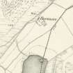
A farmstead, comprising one roofed, one unroofed building and two enclosures is depicted on the 1st edition of the OS 6-inch map (Argyllshire and Buteshire 1869, sheet ccxv). Two roofed buildings and one enclosure are shown on the current edition of the OS 1:10000 map (1980).
Information from RCAHMS (AKK) 15 October 1998.
NS 065 601 Site 95 Barmore (old)
In the field just south of Barmore farmhouse are the foundations of two rectangular buildings along with a knocking stone and a possible kiln and yard. These represent Barmore farm at some date prior to the construction of the present house in the mid 19th century. The farm is in record from 1440.
Proudfoot and Hannah 2000
NS 0653 6018 Remains of old farm buildings: Located in field just S of Barmore farmhouse. There are the foundations of two rectangular buildings, possible yard and knocking stone. There is also a possible kiln. There was a farm in record from 1440.
Information from Bute Natural History Society Deserted Settlement Survey (1991-9)
(RCAHMS WP000273)
The present house at Barmore, a two-storey cottage, is probably of early 19th century date and nothing is now visible of the five buildings depicted here on a mid 18th century estate map (Foulis 1758-9, RHP 14107/42). The knocking stone noted previously was found on the date of visit but the possible kiln was not. The grass-grown footings of a rectangular building, measuring 16m from NW to SE by 6m transversely over all, are situated immediately S of the house. It may have been a section of this building that is shown roofed on the 1st edition of the OS 6-inch map (Argyllshire and Buteshire 1869, Sheet CCXV).
Visited by RCAHMS (AGCH) 7 May 2009.
Antiquarian Mapping (1758 - 1759)
Field Visit (1991 - 1999)
NS 065 601 Site 95 Barmore (old)
In the field just south of Barmore farmhouse are the foundations of two rectangular buildings along with a knocking stone and a possible kiln and yard. These represent Barmore farm at some date prior to the construction of the present house in the mid 19th century. The farm is in record from 1440.
Proudfoot and Hannah 2000
NS 0653 6018 Remains of old farm buildings: Located in field just S of Barmore farmhouse. There are the foundations of two rectangular buildings, possible yard and knocking stone. There is also a possible kiln. There was a farm in record from 1440.
Information from Bute Natural History Society Deserted Settlement Survey (1991-9)
(RCAHMS WP000273)
Desk Based Assessment (15 October 1998)
A farmstead, comprising one roofed, one unroofed building and two enclosures is depicted on the 1st edition of the OS 6-inch map (Argyllshire and Buteshire 1869, sheet ccxv). Two roofed buildings and one enclosure are shown on the current edition of the OS 1:10000 map (1980).
Information from RCAHMS (AKK) 15 October 1998.
Field Visit (7 May 2009)
The present house at Barmore, a two-storey cottage, is probably of early 19th century date and nothing is now visible of the five buildings depicted here on a mid 18th century estate map (Foulis 1758-9, RHP 14107/42). The knocking stone noted previously was found on the date of visit but the possible kiln was not. The grass-grown footings of a rectangular building, measuring 16m from NW to SE by 6m transversely over all, are situated immediately S of the house. It may have been a section of this building that is shown roofed on the 1st edition of the OS 6-inch map (Argyllshire and Buteshire 1869, Sheet CCXV).
Visited by RCAHMS (AGCH) 7 May 2009.

